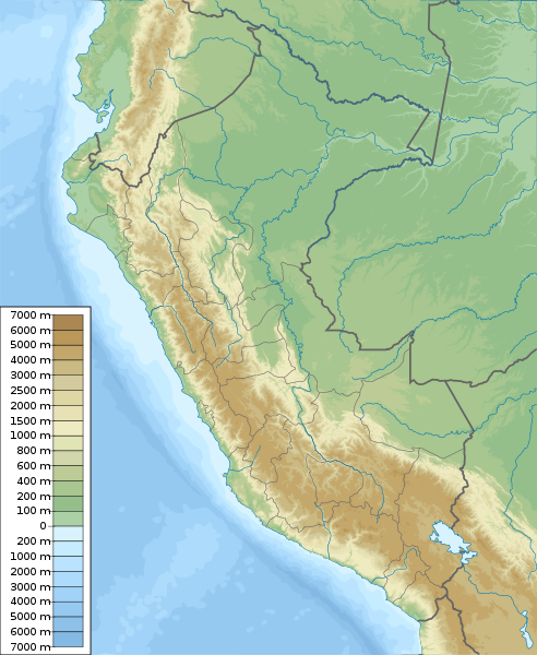
File:Peru physical map.svg
Appearance

Size of this PNG preview of this SVG file: 492 × 600 pixels. Other resolutions: 197 × 240 pixels | 394 × 480 pixels | 630 × 768 pixels | 840 × 1,024 pixels | 1,681 × 2,048 pixels | 851 × 1,037 pixels.
Original file (SVG file, nominally 851 × 1,037 pixels, file size: 4.81 MB)
File history
Click on a date/time to view the file as it appeared at that time.
| Date/Time | Thumbnail | Dimensions | User | Comment | |
|---|---|---|---|---|---|
| current | 10:42, 5 March 2011 |  | 851 × 1,037 (4.81 MB) | Urutseg | == Summary == {{Information |Description ={{en|1=Physical map of Peru, parameters are equal to Bolivia location map.svg}} |Source ={{own}} |Author =Urutseg |Date =2011-03-05 |Pe |
File usage
More than 100 pages use this file. The following list shows the first 100 pages that use this file only. A full list is available.
- 1970 Ancash earthquake
- 2001 southern Peru earthquake
- 2005 Northern Peru earthquake
- Acaray
- Alférez FAP Alfredo Vladimir Sara Bauer Airport
- Alpamayo
- Alto Mayo Protection Forest
- Ampato
- Ampay National Sanctuary
- Artesonraju
- Bahuaja-Sonene National Park
- Battle of Callao
- Blockade of Callao
- Calipuy National Reserve
- Calipuy National Sanctuary
- Caplina River
- Caral
- Cerros de Amotape National Park
- Chacamarca Historic Sanctuary
- Chan Chan
- Chavín de Huántar
- Chillón River
- Chivateros
- Choquequirao
- Colca Canyon
- Cordillera Azul National Park
- Cordillera Blanca
- Cordillera Huayhuash
- Coricancha
- Cumbemayo
- Cusco
- Cutervo National Park
- El Angolo Game Reserve
- Gran Pajatén
- Gran Vilaya
- Güeppi-Sekime National Park
- Historic Centre of Lima
- Huari (archaeological site)
- Huascarán
- Huascarán National Park
- Huayna Picchu
- Huaynaputina
- Ica River
- Jeberos
- Junín National Reserve
- Kuntur Wasi
- Kuélap
- Lachay National Reserve
- Lagunas de Mejía National Sanctuary
- Lake Conococha
- Lake Junin
- Lake Lauricocha
- Lake Palcacocha
- Lake Titicaca
- Laquipampa Wildlife Refuge
- Lima
- Llaqtapata
- Machu Picchu
- Manglares de Tumbes National Sanctuary
- Manu National Park
- Mismi
- Misti
- Moray (Inca ruin)
- Nanay River
- Nazca lines
- Pachacamac
- Pagaibamba Protection Forest
- Pampa Galeras – Barbara D'Achille National Reserve
- Pampas de Ayacucho Historic Sanctuary
- Pantanos de Villa Wildlife Refuge
- Paracas National Reserve
- Pikimachay
- Poechos Reservoir
- Pongo de Mainique
- Pongo de Manseriche
- Pui Pui Protection Forest
- Puquio Santa Rosa Protection Forest
- Písac
- Rio Abiseo National Park
- Rímac River
- Sacred Valley
- Sacsayhuamán
- San Matías–San Carlos Protection Forest
- Santa River
- Sarcophagi of Carajía
- Sillustani
- Siula Grande
- Sunchubamba Game Reserve
- Tabaconas Namballe National Sanctuary
- Tambopata National Reserve
- Tingo María National Park
- Titicaca National Reserve
- Toquepala Caves
- Tumbes River
- Túcume
- Vilcabamba, Peru
- Vitcos
- Wiñay Wayna
- Yanachaga–Chemillén National Park
- Yanawayin Lake
View more links to this file.
Global file usage
The following other wikis use this file:
- Usage on ar.wikipedia.org
- Usage on ast.wikipedia.org
- Usage on az.wikipedia.org
- Usage on ban.wikipedia.org
- Usage on ba.wikipedia.org
- Usage on bcl.wikipedia.org
- Usage on be-tarask.wikipedia.org
- Usage on be.wikipedia.org
- Usage on bg.wikipedia.org
View more global usage of this file.
