The Blue Marble, a photograph of the planet Earth made on 7 December 1972 by the crew of the Apollo 17 spacecraft.
The world is the totality of entities, the whole of reality, or everything that exists. The nature of the world has been conceptualized differently in different fields. Some conceptions see the world as unique while others talk of a "plurality of worlds". Some treat the world as one simple object while others analyze the world as a complex made up of parts.
In scientific cosmology, the world or universe is commonly defined as "[t]he totality of all space and time; all that is, has been, and will be". Theories of modality talk of possible worlds as complete and consistent ways how things could have been. Phenomenology, starting from the horizon of co-given objects present in the periphery of every experience, defines the world as the biggest horizon or the "horizon of all horizons". In philosophy of mind, the world is contrasted with the mind as that which is represented by the mind. Theology conceptualizes the world in relation to God, for example, as God's creation, as identical to God or as the two being interdependent. In religions, there is a tendency to downgrade the material or sensory world in favor of a spiritual world to be sought through religious practice. A comprehensive representation of the world and our place in it, as is found in religions, is known as a worldview. Cosmogony is the field that studies the origin or creation of the world while eschatology refers to the science or doctrine of the last things or of the end of the world.
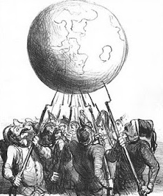
1866 cartoon by Daumier, L’Equilibre Européen, representing the balance of power as soldiers of different nations teeter the earth on bayonets.
The balance of power theory in international relations suggests that states may secure their survival by preventing any one state from gaining enough military power to dominate all others. If one state becomes much stronger, the theory predicts it will take advantage of its weaker neighbors, thereby driving them to unite in a defensive coalition. Some realists maintain that a balance-of-power system is more stable than one with a dominant state, as aggression is unprofitable when there is equilibrium of power between rival coalitions.
When threatened, states may seek safety either by balancing, allying with others against the prevailing threat; or bandwagoning, aligning themselves with the threatening power. Other alliance tactics include buck-passing and chain-ganging. Realists have long debated how the polarity of a system impacts the choice of tactics; however, it is generally agreed that in bipolar systems, each great power has no choice but to directly confront the other. Along with debates between realists about the prevalence of balancing in alliance patterns, other schools of international relations, such as constructivists, are also critical of the balance of power theory, disputing core realist assumptions regarding the international system and the behavior of states. (Full article...)
Mercator was a notable maker of globes and scientific instruments. In addition, he had interests in theology, philosophy, history, mathematics and geomagnetism. He was also an accomplished engraver and calligrapher. Unlike other great scholars of the age, he travelled little and his knowledge of geography came from his library of over a thousand books and maps, from his visitors and from his vast correspondence (in six languages) with other scholars, statesmen, travellers, merchants and seamen. Mercator's early maps were in large formats suitable for wall mounting but in the second half of his life, he produced over 100 new regional maps in a smaller format suitable for binding into his Atlas of 1595. This was the first appearance of the word Atlas in reference to a book of maps. However, Mercator used it as a neologism for a treatise (Cosmologia) on the creation, history and description of the universe, not simply a collection of maps. He chose the word as a commemoration of the Titan Atlas, "King of Mauretania", whom he considered to be the first great geographer. (Full article...)
Temperature record of the last 2,000 years (Chart showing the so-called Medieval Warm Period and Little Ice Age were not planet-wide phenomena) The global temperature record shows the fluctuations of the temperature of the atmosphere and the oceans through various spans of time. There are numerous estimates of temperatures since the end of the Pleistoceneglaciation, particularly during the current Holocene epoch. Some temperature information is available through geologic evidence, going back millions of years. More recently, information from ice cores covers the period from 800,000 years before the present time until now. A study of the paleoclimate covers the time period from 12,000 years ago to the present. Tree rings and measurements from ice cores can give evidence about the global temperature from 1,000-2,000 years before the present until now. The most detailed information exists since 1850, when methodical thermometer-based records began. Modifications on the Stevenson-type screen were made for uniform instrument measurements around 1880. (Full article...)
Image 5
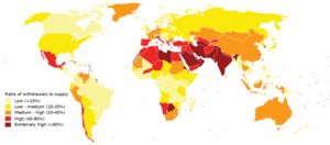
Map of global water stress (a symptom of water scarcity) in 2019. Water stress is the ratio of water use relative to water availability and is therefore a demand-driven scarcity.
Water scarcity (closely related to water stress or water crisis) is the lack of fresh waterresources to meet the standard water demand. There are two type of water scarcity namely physical and economic water scarcity. Physical water scarcity is where there is not enough water to meet all demands, including that needed for ecosystems to function. Arid areas for example Central Asia, West Asia, and North Africa often experience physical water scarcity. Economic water scarcity on the other hand, is the result of lack of investment in infrastructure or technology to draw water from rivers, aquifers, or other water sources. It also results from weak human capacity to meet water demand. Much of Sub-Saharan Africa experiences economic water scarcity.
There is enough freshwater available globally and averaged over the year to meet demand. As such, water scarcity is caused by a mismatch between when and where people need water, and when and where it is available. The main drivers of the increase in global water demand are the increasingworld population, rise in living conditions, changing diets (to more animal products), and expansion of irrigated agriculture. Climate change (including droughts or floods), deforestation, water pollution and wasteful use of water can also cause insufficient water supply. Scarcity varies over time as a result of natural variability in hydrology. These variations in scarcity may also be a function of prevailing economic policy and planning approaches. (Full article...)
The retreat of glaciers since 1850 is well documented and is one of the effects of climate change. The retreat of mountain glaciers, notably in western North America, Asia, the Alps and tropical and subtropical regions of South America, Africa and Indonesia, provide evidence for the rise in global temperatures since the late 19th century. The acceleration of the rate of retreat since 1995 of key outlet glaciers of the Greenland and West Antarcticice sheets may foreshadow a rise in sea level, which would affect coastal regions. Excluding peripheral glaciers of ice sheets, the total cumulated global glacial losses over the 26-year period from 1993 to 2018 were likely 5500 gigatons, or 210 gigatons per yr.
Deglaciation occurs naturally at the end of ice ages, but glaciologists find the current glacier retreat is accelerated by the measured increase of atmospheric greenhouse gases and is thus effect of climate change. Glacier mass balance is the key determinant of the health of a glacier. If the amount of frozen precipitation in the accumulation zone exceeds the quantity of glacial ice lost due to melting or in the ablation zone a glacier will advance; if the accumulation is less than the ablation, the glacier will retreat. Glaciers in retreat will have negative mass balances, and if they do not find an equilibrium between accumulation and ablation, will eventually disappear. (Full article...)
World peace is the concept of an ideal state of peace within and among all people and nations on Planet Earth. Different cultures, religions, philosophies, and organizations have varying concepts on how such a state would come about.
Image 10Geologic map of North America, color-coded by age. From most recent to oldest, age is indicated by yellow, green, blue, and red. The reds and pinks indicate rock from the Archean.
Image 16An artist's impression of the Archean, the eon after Earth's formation, featuring round stromatolites, which are early oxygen-producing forms of life from billions of years ago. After the Late Heavy Bombardment, Earth's crust had cooled, its water-rich barren surface is marked by continents and volcanoes, with the Moon still orbiting Earth half as far as it is today, appearing 2.8 times larger and producing strong tides. (from Earth)
Image 18Pangaea was a supercontinent that existed from about 300 to 180 Ma. The outlines of the modern continents and other landmasses are indicated on this map. (from History of Earth)
Image 20Japanese depiction of a Portuguese carrack. European maritime innovations led to proto-globalization.
Image 21Artist's impression of a Hadean landscape with the relatively newly formed Moon still looming closely over Earth and both bodies sustaining strong volcanism. (from History of Earth)
Image 40A 2012 artistic impression of the early Solar System's protoplanetary disk from which Earth and other Solar System bodies were formed (from Earth)
Image 41Cave paintings, Lascaux, France, c. 17,000 BCE
Image 42A reconstruction of human history based on fossil data. (from History of Earth)
Image 43Artist's rendition of an oxinated fully-frozen Snowball Earth with no remaining liquid surface water. (from History of Earth)
Image 44Artist's impression of Earth during the later Archean, the largely cooled planetary crust and water-rich barren surface, marked by volcanoes and continents, features already roundmicrobialites. The Moon, still orbiting Earth much closer than today and still dominating Earth's sky, produced strong tides. (from History of Earth)
Image 47Earth's night-side upper atmosphere appearing from the bottom as bands of afterglow illuminating the troposphere in orange with silhouettes of clouds, and the stratosphere in white and blue. Next the mesosphere (pink area) extends to the orange and faintly green line of the lowest airglow, at about one hundred kilometers at the edge of space and the lower edge of the thermosphere (invisible). Continuing with green and red bands of aurorae streching over several hundred kilometers. (from Earth)
Image 48Earth's western hemisphere showing topography relative to Earth's center instead of to mean sea level, as in common topographic maps (from Earth)
Image 52An animation of the changing density of productive vegetation on land (low in brown; heavy in dark green) and phytoplankton at the ocean surface (low in purple; high in yellow) (from Earth)
Image 54Trilobites first appeared during the Cambrian period and were among the most widespread and diverse groups of Paleozoic organisms. (from History of Earth)
Image 55Earth's land use for human agriculture (from Earth)
Image 56Artist's impression of the enormous collision that probably formed the Moon (from History of Earth)
Image 63A view of Earth with its global ocean and cloud cover, which dominate Earth's surface and hydrosphere; at Earth's polar regions, its hydrosphere forms larger areas of ice cover. (from Earth)
Image 68Pillar erected by India's Maurya Emperor Ashoka
Image 69A schematic view of Earth's magnetosphere with solar wind flowing from left to right (from Earth)
Image 70Empires of the world in 1898
Image 71Exaggerated illustration of Earth's elliptical orbit around the Sun, marking that the orbital extreme points (apoapsis and periapsis) are not the same as the four seasonal extreme points, the equinox and solstice (from Earth)
Image 72Conjectured illustration of the scorched Earth after the Sun has entered the red giant phase, about 5–7 billion years from now (from Earth)
Image 77Tiktaalik, a fish with limb-like fins and a predecessor of tetrapods. Reconstruction from fossils about 375 million years old. (from History of Earth)
Image 79Change in average surface air temperature and drivers for that change. Human activity has caused increased temperatures, with natural forces adding some variability. (from Earth)
Image 89Map of peopling of the world (Southern Dispersal paradigm), in thousands of years ago.
Image 90The replicator in virtually all known life is deoxyribonucleic acid. DNA is far more complex than the original replicator and its replication systems are highly elaborate. (from History of Earth)
Image 91First airplane, the Wright Flyer, flew on 17 December 1903.
Image 92Angkor Wat temple complex, Cambodia, early 12th century
... that, after her death, contemporaries of Frankish queen Austregilde both called her "the light of her homeland, the world, and the court" and compared her to Herod?
... that agronomistSimon Groot was awarded the 2019 World Food Prize for "benefiting hundreds of millions of consumers with greater access to nutritious vegetables"?
... that Dr. Disaster's office collapsed in an earthquake on this day in 2011?
... that Francis Fogarty, who went on to manage an NFL franchise for nearly two decades, was taken prisoner by the Nazis in World War II but managed to escape while wounded?
The voting for all contests consisted of two parts: experts in Ukraine voted for their seven best sites, and internet users voted for their seven favorite sites on the official website. (Full article...)
Redwood grove in Redwood National Park According to the California Protected Areas Database (CPAD), in the state of California, United States, there are over 14,000 inventoried protected areas administered by public agencies and non-profits. In addition, there are private conservation areas and other easements. They include almost one-third of California's scenic coastline, including coastal wetlands, estuaries, beaches, and dune systems. The California State Parks system alone has 270 units and covers 1.3 million acres (5,300 km2), with over 280 miles (450 km) of coastline, 625 miles (1,006 km) of lake and river frontage, nearly 18,000 campsites, and 3,000 miles (5,000 km) of hiking, biking, and equestrian trails.
Obtaining an accurate total of all protected land in California and elsewhere is a complex task. Many parcels have inholdings, private lands within the protected areas, which may or may not be accounted for when calculating total area. Also, occasionally one parcel of land is included in two or more inventories. Over 90% of Yosemite National Park for example, is listed both as wilderness by the National Wilderness Preservation System, and as national park land by the National Park Service. The Cosumnes River Preserve is an extreme example, owned and managed by a handful of public agencies and private landowners, including the Bureau of Land Management, the County of Sacramento and The Nature Conservancy. Despite the difficulties, the CPAD gives the total area of protected land at 49,294,000 acres (199,490 km2), or 47.05% of the state (not including easements); a considerable amount for the most populous state in the country. (Full article...)
A total of 8 forms of protected area are recognized under the Cambodian Protected Area Law of 2008. These are: (Full article...)
Image 3
The Protected areas of Kyrgyzstan are regulated by the law on specially protected natural areas of 2 May 2011, last modified on 2 June 2018. In total, they cover 14,761.216 km2 (5,699.337 sq mi) and account for 7.38% of the country's total area (as of 2017). The first protected area in Kyrgyzstan (Issyk-Kul) was established in 1948. According to the Government Decree on Priorities of Conservation of Biological Diversity and the relevant Action Plan for 2014-2024 the target area for the protected areas in Kyrgyzstan is 10 percent of the country’s area by 2024.
The protected areas are subdivided into seven categories: (Full article...)
Within each classification of reserve there may be a variation of IUCN categories Australia is a signatory to the Convention of Biological Diversity and as such has obligations to report the status of its National Reserve System.IUCN provides on its website a prescription for activities consistent with the categorisation system. Changes made to the Nature Conservation Act 2002 in 2014 permit timber harvesting. These changes made in addition to the already established right to access minerals means that many of the IUCN categorisations assigned to individual reserves in Tasmania are no longer fit for purpose. In addition many reserves have had their reserve status downgraded from a class excluding timber harvesting and mineral extraction to ones where these activities are now permitted. This mis-application of the IUCN protected area categories needs to be remedied or the reserves protected land class under the Nature Conservation Act 2002 should be adjusted to reflect its currently assigned IUCN category. (Full article...)
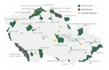
Map of protected areas of the Czech Republic: national parks (grey) and protected landscape areas (green) There are several types of protected areas of the Czech Republic. The main form of landscape protection is delimitation of special protected areas. All the types of protected areas are determined by law. (Full article...)
As of present, there are around 400 protected areas in Pakistan that are recognized by IUCN. The total protected land area represents 13% of Pakistan's landmass as of 2020, The Government of Pakistan plans to increase it to at least 15% by 2023. As a signatory of the UN Convention on Biological Diversity, Pakistan is committed to expanding its protected areas to encompass 17% of its total territory by the year 2030. This ambitious goal aims to ensure the long-term conservation of nature, safeguard vital ecosystem services, and preserve the cultural values associated with these protected areas. (Full article...)
Image 4Only a few of the largest large igneous provinces appear (coloured dark purple) on this geological map, which depicts crustal geologic provinces as seen in seismic refraction data


.jpg)
.png)


.svg)
 Tracy Caldwell Dyson, a NASA astronaut, observing Earth from the Cupola module at the International Space Station on 11 September 2010 (from Earth)
 Artist's conception of Devonian flora (from History of Earth)
 Standing Buddha from Gandhara, 2nd century CE
 Earth's axial tilt causing different angles of seasonal illumination at different orbital positions around the Sun (from Earth)
 Satellite time lapse imagery of Earth's rotation showing axis tilt (from Earth)
 Last Moon landing: Apollo 17 (1972)
 A computer-generated image mapping the prevalence of artificial satellites and space debris around Earth in geosynchronous and low Earth orbit (from Earth)
 Lithified stromatolites on the shores of Lake Thetis, Western Australia. Archean stromatolites are the first direct fossil traces of life on Earth. (from History of Earth)
 Geologic map of North America, color-coded by age. From most recent to oldest, age is indicated by yellow, green, blue, and red. The reds and pinks indicate rock from the Archean.
 A map of heat flow from Earth's interior to the surface of Earth's crust, mostly along the oceanic ridges (from Earth)
 "Lucy", the first Australopithecus afarensis skeleton found. Lucy was only 1.06 m (3 ft 6 in) tall.

 An artist's impression of the Archean, the eon after Earth's formation, featuring round stromatolites, which are early oxygen-producing forms of life from billions of years ago. After the Late Heavy Bombardment, Earth's crust had cooled, its water-rich barren surface is marked by continents and volcanoes, with the Moon still orbiting Earth half as far as it is today, appearing 2.8 times larger and producing strong tides. (from Earth)
 Obelisk of Axum, Ethiopia
 Pangaea was a supercontinent that existed from about 300 to 180 Ma. The outlines of the modern continents and other landmasses are indicated on this map. (from History of Earth)
 Ming dynasty section, Great Wall of China
 Japanese depiction of a Portuguese carrack. European maritime innovations led to proto-globalization.
 Artist's impression of a Hadean landscape with the relatively newly formed Moon still looming closely over Earth and both bodies sustaining strong volcanism. (from History of Earth)
 A Benin Bronze head from Nigeria
 Artist's conception of Hadean Eon Earth, when it was much hotter and inhospitable to all forms of life. (from History of Earth)
 A reconstruction of Pannotia (550 Ma). (from History of Earth)
 View of Earth from the Moon by the Lunar Reconnaissance Orbiter (from Earth)
 Chennakesava Temple, Belur, India
 A High Desert storm, sweeps across the Mojave (from Earth)
 Ajloun Castle, Jordan
 Image of the physical world, captured by the Hubble Space Telescope (from World)
 Fall of the Berlin Wall, 1989
 Cross-section through a liposome (from History of Earth)
 Graph showing range of estimated partial pressure of atmospheric oxygen through geologic time (from History of Earth)
 Dinosaurs were the dominant terrestrial vertebrates throughout most of the Mesozoic (from History of Earth)

 Olmec colossal head, now at the Museo de Antropología de Xalapa
 A view of Earth with different layers of its atmosphere visible: the troposphere with its clouds casting shadows, a band of stratospheric blue sky at the horizon, and a line of green airglow of the lower thermosphere around an altitude of 100 km, at the edge of space (from Earth)
 Taj Mahal, Mughal Empire, India
 A 2012 artistic impression of the early Solar System's protoplanetary disk from which Earth and other Solar System bodies were formed (from Earth)
 A reconstruction of human history based on fossil data. (from History of Earth)
 Artist's rendition of an oxinated fully-frozen Snowball Earth with no remaining liquid surface water. (from History of Earth)
 The pale orange dot, an artist's impression of the early Earth which might have appeared orange through its hazy methane rich prebiotic second atmosphere. Earth's atmosphere at this stage was somewhat comparable to today's atmosphere of Titan. (from History of Earth)
 Earth's night-side upper atmosphere appearing from the bottom as bands of afterglow illuminating the troposphere in orange with silhouettes of clouds, and the stratosphere in white and blue. Next the mesosphere (pink area) extends to the orange and faintly green line of the lowest airglow, at about one hundred kilometers at the edge of space and the lower edge of the thermosphere (invisible). Continuing with green and red bands of aurorae streching over several hundred kilometers. (from Earth)
 Earth's western hemisphere showing topography relative to Earth's center instead of to mean sea level, as in common topographic maps (from Earth)
 Notre-Dame de Paris, France
 A 580 million year old fossil of Spriggina floundensi, an animal from the Ediacaran period. Such life forms could have been ancestors to the many new forms that originated in the Cambrian Explosion. (from History of Earth)
 An animation of the changing density of productive vegetation on land (low in brown; heavy in dark green) and phytoplankton at the ocean surface (low in purple; high in yellow) (from Earth)
 Trilobites first appeared during the Cambrian period and were among the most widespread and diverse groups of Paleozoic organisms. (from History of Earth)
 Earth's land use for human agriculture (from Earth)
 Artist's impression of the enormous collision that probably formed the Moon (from History of Earth)
 Shanghai. China urbanized rapidly in the 21st century.
 Great Mosque of Kairouan, Tunisia, founded 670 CE
 Vitruvian Man by Leonardo da Vinci epitomizes the advances in art and science seen during the Renaissance. (from History of Earth)
 Chloroplasts in the cells of a moss (from History of Earth)
 Yggdrasil, an attempt to reconstruct the Norse world tree which connects the heavens, the world, and the underworld. (from World)
 A view of Earth with its global ocean and cloud cover, which dominate Earth's surface and hydrosphere; at Earth's polar regions, its hydrosphere forms larger areas of ice cover. (from Earth)
 A composite image of Earth, with its different types of surface discernible: Earth's surface dominating Ocean (blue), Africa with lush (green) to dry (brown) land and Earth's polar ice in the form of Antarctic sea ice (grey) covering the Antarctic or Southern Ocean and the Antarctic ice sheet (white) covering Antarctica. (from Earth)
 Persepolis, Achaemenid Empire, 6th century BCE
 A schematic view of Earth's magnetosphere with solar wind flowing from left to right (from Earth)
 Empires of the world in 1898

 Florence, birthplace of the Italian Renaissance
 A banded iron formation from the 3.15 Ga Moodies Group, Barberton Greenstone Belt, South Africa. Red layers represent the times when oxygen was available; gray layers were formed in anoxic circumstances. (from History of Earth)
 Battle during 1281 Mongol invasion of Japan
 Tiktaalik, a fish with limb-like fins and a predecessor of tetrapods. Reconstruction from fossils about 375 million years old. (from History of Earth)
 A composite image of artificial light emissions at night on a map of Earth (from Earth)
 Change in average surface air temperature and drivers for that change. Human activity has caused increased temperatures, with natural forces adding some variability. (from Earth)
 An artist's rendering of a protoplanetary disk (from History of Earth)
 Earth's history with time-spans of the eons to scale (from History of Earth)
 An artist's impression of ice age Earth at glacial maximum. (from History of Earth)
 Machu Picchu, Inca Empire, Peru
 A pillar at Göbekli Tepe
 The Pantheon, originally a Roman temple, now a Catholic church
 Great Pyramids of Giza, Egypt
 Map of peopling of the world (Southern Dispersal paradigm), in thousands of years ago.
 The replicator in virtually all known life is deoxyribonucleic acid. DNA is far more complex than the original replicator and its replication systems are highly elaborate. (from History of Earth)
 First airplane, the Wright Flyer, flew on 17 December 1903.
 Angkor Wat temple complex, Cambodia, early 12th century

.jpeg)


.jpg)


.jpg)

.svg)


.jpg)

.jpg)


 Time zones of the world
 Index map from the International Map of the World (1:1,000,000 scale)
 The world map by Gerardus Mercator (1569), the first map in the well-known Mercator projection
 Only a few of the largest large igneous provinces appear (coloured dark purple) on this geological map, which depicts crustal geologic provinces as seen in seismic refraction data
 1516 map of the world by Martin Waldseemüller
 United Nations Human Development Index map by country (2016)
 A plate tectonics map with volcano locations indicated with red circles
 Mollweide projection of the world
 The Goode homolosine projection is a pseudocylindrical, equal-area, composite map projection used for world maps.


 Commons
 Wikibooks
 Wikidata
 Wikinews
 Wikiquote
 Wikisource
 Wikispecies
 Wikiversity
 Wikivoyage
 Wiktionary


