
Portal:World
The World Portal


The world is the totality of entities, the whole of reality, or everything that exists. The nature of the world has been conceptualized differently in different fields. Some conceptions see the world as unique while others talk of a "plurality of worlds". Some treat the world as one simple object while others analyze the world as a complex made up of parts.
In scientific cosmology, the world or universe is commonly defined as "[t]he totality of all space and time; all that is, has been, and will be". Theories of modality talk of possible worlds as complete and consistent ways how things could have been. Phenomenology, starting from the horizon of co-given objects present in the periphery of every experience, defines the world as the biggest horizon or the "horizon of all horizons". In philosophy of mind, the world is contrasted with the mind as that which is represented by the mind. Theology conceptualizes the world in relation to God, for example, as God's creation, as identical to God or as the two being interdependent. In religions, there is a tendency to downgrade the material or sensory world in favor of a spiritual world to be sought through religious practice. A comprehensive representation of the world and our place in it, as is found in religions, is known as a worldview. Cosmogony is the field that studies the origin or creation of the world while eschatology refers to the science or doctrine of the last things or of the end of the world.
In various contexts, the term "world" takes a more restricted meaning associated, for example, with the Earth and all life on it, with humanity as a whole or with an international or intercontinental scope. In this sense, world history refers to the history of humanity as a whole and world politics is the discipline of political science studying issues that transcend nations and continents. Other examples include terms such as "world religion", "world language", "world government", "world war", "world population", "world economy", or "world championship". (Full article...)
Selected articles -
-


Gerardus Mercator (/dʒɪˈrɑːrdəs mɜːrˈkeɪtər/; 5 March 1512 – 2 December 1594) was a Flemish geographer, cosmographer and cartographer. He is most renowned for creating the 1569 world map based on a new projection which represented sailing courses of constant bearing (rhumb lines) as straight lines—an innovation that is still employed in nautical charts.
Mercator was a notable maker of globes and scientific instruments. In addition, he had interests in theology, philosophy, history, mathematics and geomagnetism. He was also an accomplished engraver and calligrapher. Unlike other great scholars of the age, he travelled little and his knowledge of geography came from his library of over a thousand books and maps, from his visitors and from his vast correspondence (in six languages) with other scholars, statesmen, travellers, merchants and seamen. Mercator's early maps were in large formats suitable for wall mounting but in the second half of his life, he produced over 100 new regional maps in a smaller format suitable for binding into his Atlas of 1595. This was the first appearance of the word Atlas in reference to a book of maps. However, Mercator used it as a neologism for a treatise (Cosmologia) on the creation, history and description of the universe, not simply a collection of maps. He chose the word as a commemoration of the Titan Atlas, "King of Mauretania", whom he considered to be the first great geographer. (Full article...) -
World Englishes is a term for emerging localised or indigenised varieties of English, especially varieties that have developed in territories influenced by the United Kingdom or the United States. The study of World Englishes consists of identifying varieties of English used in diverse sociolinguistic contexts globally and analyzing how sociolinguistic histories, multicultural backgrounds and contexts of function influence the use of English in different regions of the world.
The issue of World Englishes was first raised in 1978 to examine concepts of regional Englishes globally. Pragmatic factors such as appropriateness, comprehensibility and interpretability justified the use of English as an international and intra-national language. In 1988, at a Teachers of English to Speakers of Other Languages (TESOL) conference in Honolulu, Hawaii, the International Committee of the Study of World Englishes (ICWE) was formed. In 1992, the ICWE formally launched the International Association for World Englishes (IAWE) at a conference of "World Englishes Today", at the University of Illinois, USA. There are two academic journals devoted to the study of this topic, titled English World-Wide (since 1980) and World Englishes (since 1982). There are a number of published handbooks and textbooks on the subject. (Full article...) -

Distribution by country as of 2018
UNESCO established its Lists of Intangible Cultural Heritage with the aim of ensuring better protection of important intangible cultural heritages worldwide and the awareness of their significance. This list is published by the Intergovernmental Committee for the Safeguarding of Intangible Cultural Heritage, the members of which are elected by State Parties meeting in a General Assembly. Through a compendium of the different oral and intangible treasures of humankind worldwide, the programme aims to draw attention to the importance of safeguarding intangible heritage, which UNESCO has identified as an essential component and as a repository of cultural diversity and of creative expression.
The list was established in 2008 when the 2003 Convention for the Safeguarding of the Intangible Cultural Heritage took effect. (Full article...) -
The earliest known world maps date to classical antiquity, the oldest examples of the 6th to 5th centuries BCE still based on the flat Earth paradigm. World maps assuming a spherical Earth first appear in the Hellenistic period. The developments of Greek geography during this time, notably by Eratosthenes and Posidonius culminated in the Roman era, with Ptolemy's world map (2nd century CE), which would remain authoritative throughout the Middle Ages. Since Ptolemy, knowledge of the approximate size of the Earth allowed cartographers to estimate the extent of their geographical knowledge, and to indicate parts of the planet known to exist but not yet explored as terra incognita.
With the Age of Discovery, during the 15th to 18th centuries, world maps became increasingly accurate; exploration of Antarctica, Australia, and the interior of Africa by western mapmakers was left to the 19th and early 20th century. (Full article...) -
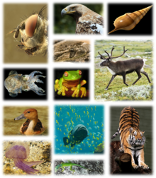
Examples of the multicellular biodiversity of the Earth.
Global biodiversity is the measure of biodiversity on planet Earth and is defined as the total variability of life forms. More than 99 percent of all species that ever lived on Earth are estimated to be extinct. Estimates on the number of Earth's current species range from 2 million to 1 trillion, but most estimates are around 11 million species or fewer. About 1.74 million species were databased as of 2018, and over 80 percent have not yet been described. The total amount of DNA base pairs on Earth, as a possible approximation of global biodiversity, is estimated at 5.0 x 1037, and weighs 50 billion tonnes. In comparison, the total mass of the biosphere has been estimated to be as much as 4 TtC (trillion tons of carbon).
In other related studies, around 1.9 million extant species are believed to have been described currently, but some scientists believe 20% are synonyms, reducing the total valid described species to 1.5 million. In 2013, a study published in Science estimated there to be 5 ± 3 million extant species on Earth although that is disputed. Another study, published in 2011 by PLoS Biology, estimated there to be 8.7 million ± 1.3 million eukaryotic species on Earth. Some 250,000 valid fossil species have been described, but this is believed to be a small proportion of all species that have ever lived. (Full article...) -

The League of Nations (French: Société des Nations [sɔsjete de nɑsjɔ̃]) was the first worldwide intergovernmental organisation whose principal mission was to maintain world peace. It was founded on 10 January 1920 by the Paris Peace Conference that ended the First World War. The main organization ceased operations on 18 April 1946 when many of its components were relocated into the new United Nations. As the template for modern global governance, the League profoundly shaped the modern world.
The League's primary goals were stated in its eponymous Covenant. They included preventing wars through collective security and disarmament and settling international disputes through negotiation and arbitration. Its other concerns included labour conditions, just treatment of native inhabitants, human and drug trafficking, the arms trade, global health, prisoners of war, and protection of minorities in Europe. The Covenant of the League of Nations was signed on 28 June 1919 as Part I of the Treaty of Versailles, and it became effective with the rest of the Treaty on 10 January 1920. Australia was granted the right to participate as an autonomous member nation, marking the start of Australian independence on the global stage. The first meeting of the Council of the League took place on 16 January 1920, and the first meeting of the Assembly of the League took place on 15 November 1920. In 1919, U.S. president Woodrow Wilson won the Nobel Peace Prize for his role as the leading architect of the League. (Full article...) -
The Alps (/ælps/) are the highest and most extensive mountain range that is entirely in Europe, stretching approximately 1,200 km (750 mi) across eight Alpine countries (from west to east): Monaco, France, Switzerland, Italy, Liechtenstein, Germany, Austria and Slovenia.
The Alpine arch extends from Nice on the western Mediterranean to Trieste on the Adriatic and Vienna at the beginning of the Pannonian Basin. The mountains were formed over tens of millions of years as the African and Eurasian tectonic plates collided. Extreme shortening caused by the event resulted in marine sedimentary rocks rising by thrusting and folding into high mountain peaks such as Mont Blanc and the Matterhorn. (Full article...)

.png)
.png)

.svg)

General images -
-
 Satellite time lapse imagery of Earth's rotation showing axis tilt (from Earth)
 -
 Taj Mahal, Mughal Empire, India
 -
 Great Mosque of Kairouan, Tunisia, founded 670 CE
 -
 Persepolis, Achaemenid Empire, 6th century BCE
 -
 Fall of the Berlin Wall, 1989
 -

-
 A view of Earth with different layers of its atmosphere visible: the troposphere with its clouds casting shadows, a band of stratospheric blue sky at the horizon, and a line of green airglow of the lower thermosphere around an altitude of 100 km, at the edge of space (from Earth)
 -
 A composite image of artificial light emissions at night on a map of Earth (from Earth)
 -
 Artist's impression of Earth during the later Archean, the largely cooled planetary crust and water-rich barren surface, marked by volcanoes and continents, features already round microbialites. The Moon, still orbiting Earth much closer than today and still dominating Earth's sky, produced strong tides. (from History of Earth)
 -

-
 Tiktaalik, a fish with limb-like fins and a predecessor of tetrapods. Reconstruction from fossils about 375 million years old. (from History of Earth)
 -

-
 Artist's conception of Devonian flora (from History of Earth)
 -
 A reconstruction of human history based on fossil data. (from History of Earth)
 -

-

-
 Tracy Caldwell Dyson, a NASA astronaut, observing Earth from the Cupola module at the International Space Station on 11 September 2010 (from Earth)
 -
An artist's impression of the Archean, the eon after Earth's formation, featuring round stromatolites, which are early oxygen-producing forms of life from billions of years ago. After the Late Heavy Bombardment, Earth's crust had cooled, its water-rich barren surface is marked by continents and volcanoes, with the Moon still orbiting Earth half as far as it is today, appearing 2.8 times larger and producing strong tides. (from Earth)
-

-
 Graph showing range of estimated partial pressure of atmospheric oxygen through geologic time (from History of Earth)
 -
 Earth's axial tilt causing different angles of seasonal illumination at different orbital positions around the Sun (from Earth)
 -
 Vitruvian Man by Leonardo da Vinci epitomizes the advances in art and science seen during the Renaissance. (from History of Earth)
 -
 Earth's history with time-spans of the eons to scale (from History of Earth)
 -
 A computer-generated image mapping the prevalence of artificial satellites and space debris around Earth in geosynchronous and low Earth orbit (from Earth)
 -
 View of Earth from the Moon by the Lunar Reconnaissance Orbiter (from Earth)
 -

-
 Lithified stromatolites on the shores of Lake Thetis, Western Australia. Archean stromatolites are the first direct fossil traces of life on Earth. (from History of Earth)
 -
 The pale orange dot, an artist's impression of the early Earth which might have appeared orange through its hazy methane rich prebiotic second atmosphere. Earth's atmosphere at this stage was somewhat comparable to today's atmosphere of Titan. (from History of Earth)
 -

-

-
 Earth's night-side upper atmosphere appearing from the bottom as bands of afterglow illuminating the troposphere in orange with silhouettes of clouds, and the stratosphere in white and blue. Next the mesosphere (pink area) extends to the orange and faintly green line of the lowest airglow, at about one hundred kilometers at the edge of space and the lower edge of the thermosphere (invisible). Continuing with green and red bands of aurorae stretching over several hundred kilometers. (from Earth)
 -
 A reconstruction of Pannotia (550 Ma). (from History of Earth)
 -
 Yggdrasil, an attempt to reconstruct the Norse world tree which connects the heavens, the world, and the underworld. (from World)
 -

-
 Change in average surface air temperature and drivers for that change. Human activity has caused increased temperatures, with natural forces adding some variability. (from Earth)
 -
 Trilobites first appeared during the Cambrian period and were among the most widespread and diverse groups of Paleozoic organisms. (from History of Earth)
 -

-
 Angkor Wat temple complex, Cambodia, early 12th century
 -

-
 A pillar at Göbekli Tepe
 -
 Map of peopling of the world (Southern Dispersal paradigm), in thousands of years ago.
 -

-
 Ming dynasty section, Great Wall of China
 -
 Battle during 1281 Mongol invasion of Japan
 -
 Great Pyramids of Giza, Egypt
 -
 Olmec colossal head, now at the Museo de Antropología de Xalapa
 -
 Last Moon landing: Apollo 17 (1972)
 -
 Artist's conception of Hadean Eon Earth, when it was much hotter and inhospitable to all forms of life. (from History of Earth)
 -
 Artist's rendition of an oxinated fully-frozen Snowball Earth with no remaining liquid surface water. (from History of Earth)
 -

-

-
 A 580 million year old fossil of Spriggina floundensi, an animal from the Ediacaran period. Such life forms could have been ancestors to the many new forms that originated in the Cambrian Explosion. (from History of Earth)
 -
 Artist's impression of a Hadean landscape with the relatively newly formed Moon still looming closely over Earth and both bodies sustaining strong volcanism. (from History of Earth)
 -

-
 Chloroplasts in the cells of a moss (from History of Earth)
 -
 A schematic view of Earth's magnetosphere with solar wind flowing from left to right (from Earth)
 -
 Machu Picchu, Inca Empire, Peru
 -
 Chennakesava Temple, Belur, India
 -
 The replicator in virtually all known life is deoxyribonucleic acid. DNA is far more complex than the original replicator and its replication systems are highly elaborate. (from History of Earth)
 -
 A 2012 artistic impression of the early Solar System's protoplanetary disk from which Earth and other Solar System bodies were formed (from Earth)
 -
 Artist's impression of the enormous collision that probably formed the Moon (from History of Earth)
 -
 Florence, birthplace of the Italian Renaissance
 -
 Geologic map of North America, color-coded by age. From most recent to oldest, age is indicated by yellow, green, blue, and red. The reds and pinks indicate rock from the Archean.
 -
 A banded iron formation from the 3.15 Ga Moodies Group, Barberton Greenstone Belt, South Africa. Red layers represent the times when oxygen was available; gray layers were formed in anoxic circumstances. (from History of Earth)
 -
 A Benin Bronze head from Nigeria
 -
 The Pantheon, originally a Roman temple, now a Catholic church
 -
 A composite image of Earth, with its different types of surface discernible: Earth's surface dominating Ocean (blue), Africa with lush (green) to dry (brown) land and Earth's polar ice in the form of Antarctic sea ice (grey) covering the Antarctic or Southern Ocean and the Antarctic ice sheet (white) covering Antarctica. (from Earth)
 -

-
 Obelisk of Axum, Ethiopia
 -
 An animation of the changing density of productive vegetation on land (low in brown; heavy in dark green) and phytoplankton at the ocean surface (low in purple; high in yellow) (from Earth)
 -
 First airplane, the Wright Flyer, flew on 17 December 1903.
 -
 "Lucy", the first Australopithecus afarensis skeleton found. Lucy was only 1.06 m (3 ft 6 in) tall.
 -
 A view of Earth with its global ocean and cloud cover, which dominate Earth's surface and hydrosphere; at Earth's polar regions, its hydrosphere forms larger areas of ice cover. (from Earth)
 -
Pale orange dot, an artist's impression of Early Earth, featuring its tinted orange methane-rich early atmosphere (from Earth)
-
 Cross-section through a liposome (from History of Earth)
 -
 Japanese depiction of a Portuguese carrack. European maritime innovations led to proto-globalization.
 -
 Ajloun Castle, Jordan
 -
 Notre-Dame de Paris, France
 -
 Image of the physical world, captured by the Hubble Space Telescope (from World)
 -
 Dinosaurs were the dominant terrestrial vertebrates throughout most of the Mesozoic (from History of Earth)
 -
 An artist's rendering of a protoplanetary disk (from History of Earth)
 -
 Shanghai. China urbanized rapidly in the 21st century.
 -
 Earth's western hemisphere showing topography relative to Earth's center instead of to mean sea level, as in common topographic maps (from Earth)
 -

-
 Earth's land use for human agriculture in 2019 (from Earth)
 -

-

-
 Empires of the world in 1898
 -
 Standing Buddha from Gandhara, 2nd century CE
 -
 An artist's impression of ice age Earth at glacial maximum. (from History of Earth)
 -
 Pangaea was a supercontinent that existed from about 300 to 180 Ma. The outlines of the modern continents and other landmasses are indicated on this map. (from History of Earth)
 -
 A map of heat flow from Earth's interior to the surface of Earth's crust, mostly along the oceanic ridges (from Earth)


.jpg)


.svg)

.jpg)


.jpg)


.jpeg)


Megacities of the world -

Moscow is the capital and largest city of Russia. The city stands on the Moskva River in Central Russia, with a population estimated at 13.0 million residents within the city limits, over 18.8 million residents in the urban area, and over 21.5 million residents in the metropolitan area. The city covers an area of 2,511 square kilometers (970 sq mi), while the urban area covers 5,891 square kilometers (2,275 sq mi), and the metropolitan area covers over 26,000 square kilometers (10,000 sq mi). Moscow is among the world's largest cities, being the most populous city in its entirety in Europe, the largest urban and metropolitan area in Europe, and the largest city by land area on the European continent.
First documented in 1147, Moscow grew to serve as the capital of the Grand Duchy of Moscow. When the Tsardom of Russia was proclaimed, Moscow remained the political and economic center for most of its history. Under the reign of Peter the Great, the Russian capital was moved to the newly founded city of Saint Petersburg in 1712, decreasing Moscow's influence. Following the Russian Revolution and the establishment of the Russian SFSR, the capital was moved back to Moscow in 1918, where it later became the political center of the Soviet Union. In the aftermath of the dissolution of the Soviet Union, Moscow remained the capital city of the newly established Russian Federation. (Full article...)Did you know -

- ... that Belinda Archer won Australia's first World Artistic Gymnastics Championships team medal in 2003?
- ... that Fernhill House has been home to a butter merchant, an Ulster Volunteer Force armoury, a Grand National-winning racehorse and the world's largest collection of Orange Order memorabilia?
- ... that Magnus Carlsen, the current World Chess Champion, resigned a recent tournament game after only one move?
- ... that sports broadcaster Gene Principe had to choose between covering his hometown team at the 2006 NHL playoffs and his "pure dream" of covering the Italian team at the 2006 FIFA World Cup?
- ... that the 1994 Mascara earthquake destroyed every house in the Algerian villages of Shadlia, Hacine and Sidi Ali Cherif?
- ... that Jane Dempsey Douglass became the first woman to head a worldwide communion of churches in 1990?
- ... that the first prayer of "Hilf, Herr meines Lebens", a Christian song written when its author was age 85, is not to be on earth in vain?
- ... that the flag of Sark represented the last feudal state in the Western world, and is flown over the British Ministry of Justice every 6 August to commemorate the granting of the fief?
Countries of the world -

Trinidad and Tobago (/ˈtrɪnɪdæd ... təˈbeɪɡoʊ/ ⓘ, /- toʊ-/, TRIN-ih-dad ... tə-BAY-goh, - toh-), officially the Republic of Trinidad and Tobago, is the southernmost island country in the Caribbean. Consisting of the main islands Trinidad and Tobago and numerous much smaller islands, it is situated 11 kilometres (6.8 miles) off the coast of northeastern Venezuela and 130 kilometres (81 miles) south of Grenada. It shares maritime boundaries with Barbados to the east, Grenada to the northwest and Venezuela to the south and west. Trinidad and Tobago is generally considered to be part of the West Indies. The island country's capital is Port of Spain, while its largest and most populous municipality is Chaguanas.
The island of Trinidad was inhabited for centuries by Indigenous peoples before becoming a colony in the Spanish Empire, following the arrival of Christopher Columbus, in 1498. Spanish governor José María Chacón surrendered the island to a British fleet under the command of Sir Ralph Abercromby in 1797. Trinidad and Tobago were ceded to Britain in 1802 under the Treaty of Amiens as separate states and unified in 1889. Trinidad and Tobago obtained independence in 1962, becoming a republic in 1976. (Full article...)
The New 7 Wonders of the World was a campaign started in 2001 to choose Wonders of the World from a selection of 200 existing monuments. The popularity poll via free Web-based voting and small amounts of telephone voting was led by Canadian-Swiss Bernard Weber and organized by the New 7 Wonders Foundation (N7W) based in Zurich, Switzerland, with winners announced on 7 July 2007 in Lisbon, at Estádio da Luz. The poll was considered unscientific partly because it was possible for people to cast multiple votes. According to John Zogby, founder and current President/CEO of the Utica, New York–based polling organization Zogby International, New 7 Wonders Foundation drove "the largest poll on record".
The program drew a wide range of official reactions. Some countries touted their finalist and tried to get more votes cast for it, while others downplayed or criticized the contest. After supporting the New 7 Wonders Foundation at the beginning of the campaign by providing advice on nominee selection, the United Nations Educational, Scientific, and Cultural Organization (UNESCO), bound by its bylaws to record and give equal status to all World Heritage Sites, distanced itself from the undertaking in 2001 and again in 2007. (Full article...)Related portals
Protected areas of the world -
-
As of present, there are around 400 protected areas in Pakistan that are recognized by IUCN. The total protected land area represents 13% of Pakistan's landmass as of 2020, The Government of Pakistan plans to increase it to at least 15% by 2023. As a signatory of the UN Convention on Biological Diversity, Pakistan is committed to expanding its protected areas to encompass 17% of its total territory by the year 2030. This ambitious goal aims to ensure the long-term conservation of nature, safeguard vital ecosystem services, and preserve the cultural values associated with these protected areas. (Full article...)
-
This is a list of protected areas of Saudi Arabia, some of which are managed by the Saudi Wildlife Authority.:
- At-Taysiyah Protected Area
- Jabal Shada Nature Reserve
- Majami'al-Hadb Protected Area
- Nafud al-'Urayq
- Raydah Natural Reserve
- 'Uruq Bani Ma'arid
- Saja Umm Ar-Rimth Natural Reserve
- Harrat al-Harrah Protected Area
- Al-Khunfah Natural Reserve
- Ibex Reserve Protected Area
- Mahazat as-Sayd Protected Area
- Umm al-Qamari Islands
- Al-Tubayq Natural Reserve
- Farasan Islands Protected Area
- Jubail Marine Wildlife Sanctuary
- Jabal Aja Protected Area
- Wadi Turabah Nature Reserve
-
The following list of protected areas of British Columbia includes all federally and provincially protected areas within the Canadian province of British Columbia. As of 2015, approximately 15.46% of the province's land area and 3.17% of the province's waters are protected. (Full article...)
-
A National Biodiversity Conservation Area (NBCA) is an environmentally protected area in Laos. There are all together 21 different NBCAs in Laos, protecting 29,775 square kilometers. Another 10 NBCAs have been proposed, many of them being treated by authorities as though they were already officially protected. (Full article...)
-
-
Protected areas of Slovenia include one national park (Slovene: narodni park), three regional parks (regijski park), several natural parks (krajinski park), and hundreds of natural monuments (naravni spomenik) and monuments of designed nature (spomenik oblikovane narave). They cover about 12.5% of the Slovenian territory. Under the Wild Birds Directive, 26 sites totalling roughly 25% of the nation's land are "Special Protected Areas"; the Natura 2000 proposal would increase the totals to 260 sites and 32% of national territory. (Full article...)
-
The protected areas of Michigan come in an array of different types and levels of protection. Michigan has five units of the National Park Service system. There are 14 federal wilderness areas; the majority of these are also tribal-designated wildernesses. It has one of the largest state forest systems as well having four national forests. The state maintains a large state park system and there are also regional parks, and county, township and city parks. Still other parks on land and in the Great Lakes are maintained by other governmental bodies. Private protected areas also exist in the state, mainly lands owned by land conservancies. (Full article...)
-
This is a list of protected areas of Sierra Leone, including national parks, game reserves, conservation areas, wetlands, and those that are listed as proposed protected areas in the UN Environment Programme World Conservation Monitoring Centre (UNEP WCM) database. (Full article...)
-

Cranes at Sevan National Park
This is a list of protected areas in Armenia that are categorized as follows: 4 national parks, 3 state reserves, 27 state sanctuaries and 5 botanical gardens. (Full article...) -
Protected areas of the European Union are areas which need and/or receive special protection because of their environmental, cultural or historical value to the member states of the European Union.
(Full article...) -
-
-
The protected areas of Finland include national parks, nature reserves and other areas, with a purpose of conserving areas of all of Finland's ecosystems and biotopes.
Protected areas include:- National parks of Finland (Kansallispuisto/Nationalpark) - 8,170 km2
- Strict nature reserves of Finland (Luonnonpuisto/Naturreservat) - 1,530 km2
- Mire reserves of Finland (Soidensuojelualue/Myrskyddsområde) - 4,490 km2
- Protected herb-rich forest areas (Lehtojensuojelualue/Lundskyddsområde) - 13 km2
- Protected old-growth forest areas (Vanhat metsät/Gamla skogar) - 100 km2
- Grey seal protection areas (Hylkeidensuojelualue/Sälskyddsområde) - 190 km2
- Other protected areas on state-owned land - 468 km2
-
Dinosaur Provincial Park
This is a list of protected areas of Alberta. Protected areas are managed by the Government of Canada or the Government of Alberta. The provincial government owns 60% of Alberta's landmass but most of this has not been formally protected. The total protected area throughout Alberta including federal and provincial protected areas is approximately 90,700 km2 (35,000 sq mi). (Full article...) -
Total size of protected area of Bosnia and Herzegovina amounts of 57.83694 hectares (142.9182 acres), which is 1,13% of its entire territory. This is a list of areas protected by corresponding levels of the government of Bosnia and Herzegovina, namely at the entity's levels, and with various categorizations. (Full article...)


Selected world maps
-
 Time zones of the world
 -
 1516 map of the world by Martin Waldseemüller
 -
 United Nations Human Development Index map by country (2016)
 -
 A plate tectonics map with volcano locations indicated with red circles
 -
 The world map by Gerardus Mercator (1569), the first map in the well-known Mercator projection
 -
 The Goode homolosine projection is a pseudocylindrical, equal-area, composite map projection used for world maps.
 -
 Index map from the International Map of the World (1:1,000,000 scale)
 -
 Mollweide projection of the world
 -
 Only a few of the largest large igneous provinces appear (coloured dark purple) on this geological map, which depicts crustal geologic provinces as seen in seismic refraction data


World records
- List of Olympic records in athletics
- List of world records in athletics
- List of junior world records in athletics
- List of world records in masters athletics
- List of world youth bests in athletics
- List of IPC world records in athletics
- List of world records in canoeing
- List of world records in chess
- List of cycling records
- List of world records in track cycling
- List of world records in finswimming
- List of world records in juggling
- List of world records in rowing
- List of world records in speed skating
- List of world records in swimming
- List of IPC world records in swimming
- List of world records in Olympic weightlifting
Topics

Continents of Earth | ||||||||
|---|---|---|---|---|---|---|---|---|
| ||||||||
| ||||||||
| ||||||||


| Cenozoic Era (present–66.0 Ma) |
| ||||||||||||
|---|---|---|---|---|---|---|---|---|---|---|---|---|---|
| Mesozoic Era (66.0–252 Ma) |
| ||||||||||||
| Paleozoic Era (252–539 Ma) |
| ||||||||||||
| Proterozoic Eon (539 Ma–2.5 Ga) |
| ||||||||||||
| Archean Eon (2.5–4 Ga) | |||||||||||||
| Hadean Eon (4–4.6 Ga) | |||||||||||||
ka = kiloannum (thousands years ago); Ma = megaannum (millions years ago); Ga = gigaannum (billions years ago). See also: Geologic time scale • | |||||||||||||
| Locations | ||
|---|---|---|
| Related | ||

| |||||||||||||||||||
| |||||||||||||||||||
| |||||||||||||||||||

Economic classification of countries | |||||
|---|---|---|---|---|---|
| Three-World Model | |||||
| Gross domestic product (GDP) |
| ||||
| Gross national income (GNI) | |||||
| Wages | |||||
| Wealth | |||||
| Other national accounts | |||||
| Human development | |||||
| Digital divide | |||||
| Net international investment position (NIIP) | |||||
| Technological |
| ||||
|---|---|---|---|---|---|
| Sociological | |||||
| Ecological |
| ||||
| Biological |
| ||||
| Astronomical | |||||
| Eschatological |
| ||||
| Others |
| ||||
| Fictional | |||||
| Organizations | |||||
Categories

Wikimedia
The following Wikimedia Foundation sister projects provide more on this subject:
-
 Commons
Free media repository -
 Wikibooks
Free textbooks and manuals -
 Wikidata
Free knowledge base -
 Wikinews
Free-content news -
 Wikiquote
Collection of quotations -
 Wikisource
Free-content library -
 Wikispecies
Directory of species -
 Wikiversity
Free learning tools -
 Wikivoyage
Free travel guide -
 Wiktionary
Dictionary and thesaurus


