
Zabrekve
Zabrekve | |
|---|---|
 Zabrekve Location in Slovenia | |
| Coordinates: 46°14′8.61″N 14°14′12.16″E / 46.2357250°N 14.2367111°E | |
| Country | |
| Traditional Region | Upper Carniola |
| Statistical region | Upper Carniola |
| Municipality | Železniki |
| Elevation | 822.2 m (2,697.5 ft) |
| Population (2002) | |
| • Total | 66 |
| [1] | |
Zabrekve (pronounced [zaˈbɾeːkʋɛ]) is a settlement in the Municipality of Železniki in the Upper Carniola region of Slovenia. It includes the hamlets of Sveti Mohor (Sankt Hermagor[2]) and Bezovnica.[3]
History[edit]
During the Second World War, the Partisans burned the hamlet of Bezovnica on 10 March 1945.[2][4]
Church[edit]
The local church is dedicated to Saints Hermagoras and Fortunatus and was rebuilt in 1973. The original Baroque church was dynamited in the spring of 1944[2][4] or in March 1945[5] and the surviving bell tower burned down in 1972 after being struck by lightning.[6]
Gallery[edit]
-
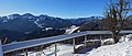 Hay rack in Zabrekve and view to the west

References[edit]
- ^ Statistical Office of the Republic of Slovenia
- ^ a b c Leksikon občin kraljestev in dežel zastopanih v državnem zboru, vol. 6: Kranjsko. Vienna: C. Kr. Dvorna in Državna Tiskarna. 1906. p. 62.
- ^ Savnik, Roman (1968). Krajevni leksikon Slovenije, vol. 1. Ljubljana: Državna založba Slovenije. p. 384.
- ^ a b Planina, France. 1973. "Pokrajina in kraji Selške doline." Selška dolina v preteklosti in sedanjosti, pp. 9–48. Škofja Loka: Muzejsko društvo v Škofji Loki, pododbor Železniki, p. 27. (in Slovene)
- ^ Podružnice - Sv. Mohor in Fortunat (in Slovene)
- ^ Selca parish website
External links[edit]
| Settlements | Administrative seat: Železniki
|  | ||||
|---|---|---|---|---|---|---|
| Landmarks | ||||||
| Notable people | ||||||
This article about the Municipality of Železniki in Slovenia is a stub. You can help Wikipedia by expanding it. |