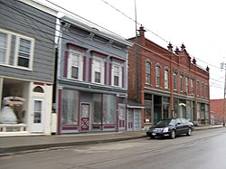
Worcester Historic District
Worcester Historic District | |
 Worcester Historic District, April 2010 | |
| Location | Both sides of Main St. (NY 7) between Decatur and Cook Sts., Worcester, New York |
|---|---|
| Coordinates | 42°35′31″N 74°45′0″W / 42.59194°N 74.75000°W |
| Area | 5 acres (2.0 ha) |
| NRHP reference No. | 75001221[1] |
| Added to NRHP | June 10, 1975 |
Worcester Historic District is a national historic district located at Worcester in Otsego County, New York. It encompasses 24 contributing buildings representing the social and economic nucleus of the town. It is composed partially of frame buildings whose street fronts are distinguished by false fronts or "boomtown" facades and a variety of commercial and residential structures.[2]
It was listed on the National Register of Historic Places in 1975.[1]
References[edit]
- ^ a b "National Register Information System". National Register of Historic Places. National Park Service. March 13, 2009.
- ^ Nancy C. Hage (September 1974). "National Register of Historic Places Registration: Worcester Historic District". New York State Office of Parks, Recreation and Historic Preservation. Retrieved January 14, 2010. See also: "Accompanying four photos".
Categories:
- Historic districts on the National Register of Historic Places in New York (state)
- Houses on the National Register of Historic Places in New York (state)
- Historic districts in Otsego County, New York
- National Register of Historic Places in Otsego County, New York
- Otsego County, New York Registered Historic Place stubs


