
Wola
Wola | |
|---|---|
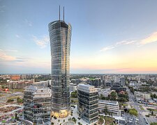
 Intersection of Towarowa and Prosta streets | |
 Location of Wola within Warsaw | |
 Neighbourhoods of Wola | |
| Country | |
| Voivodeship | Masovian |
| County/City | Warsaw |
| Government | |
| • Mayor | Krzysztof Strzałkowski |
| Area | |
• Total | 19.26 km2 (7.44 sq mi) |
| Population (2019) | |
• Total | 140,958[1] |
| Time zone | UTC+1 (CET) |
| • Summer (DST) | UTC+2 (CEST) |
| Area code | +48 22 |
| Car plates | WY |
| Website | wola.waw.pl |

Wola (Polish pronunciation: [ˈvɔla] ) is a district in western Warsaw, Poland. An industrial area with traditions reaching back to the early 19th century, it underwent a transformation into a major financial district, featuring various landmarks and some of the tallest office buildings in the city.
History
[edit]First mentioned in the 14th century, it became the site of the elections, from 1573 to 1764, of Polish kings by the szlachta (nobility) of the Polish–Lithuanian Commonwealth. The Wola district later became famous for the Polish Army's defence of Warsaw in 1794 during the Kościuszko Uprising and in 1831 during the November Uprising, when Józef Sowiński and Józef Bem defended the city against Tsarist forces.[2]
In the 19th century, Wola developed as a factory and workers' district. During the 1905 revolution, a May Day march led by Felix Dzerzhinsky ended in clashes with the police, resulting in 25 deaths[3].
Until being incorporated into Warsaw in 1916, Wola was the village of Wielka Wola.[2]
During the Warsaw Uprising (August–October 1944), fierce battles raged in Wola. Around 8 August, Wola was the scene of the largest single massacre by German forces in Poland, of 40,000 to 50,000 civilians. The area was held by Polish fighters belonging to the Armia Krajowa.[4]
Wola is currently divided into the neighbourhoods of Czyste, Koło, Mirów, Młynów, Nowolipki, Odolany, Powązki and Ulrychów, which in many cases correspond to old villages or settlements.[5]
Skyscrapers
[edit]
Numerous office and residential high-rises of up to 53 stories have been built in Wola since the 1990s. Most of them are concentrated along the Towarowa and Prosta streets; these include Varso Tower (310 m (1,020 ft)), Warsaw Spire (220 m (720 ft)), Warsaw Unit (202 m (663 ft)), Skyliner (195 m (640 ft)), Warsaw Trade Tower (187 m (614 ft)), The Warsaw Hub (130 m (430 ft) x2), Łucka City (120 m (390 ft)), Ilmet (103 m (338 ft)) and Warta Tower (82 m (269 ft)).[6]
Many other buildings rising over 100 metres (330 ft) are currently undergoing construction in Wola, such as the office skyscrapers The Bridge (174 m (571 ft)) and Skyliner II (130 m (430 ft)), the Towarowa 22 complex ((150 m (490 ft), (120 m (390 ft) and (110 m (360 ft)), and the residential Towarowa Towers (105 m (344 ft) x2).[6]
Historic landmarks
[edit]- St. Lawrence's Church - built 1695–1755
- Church of St Charles Borromeo - designed by Enrico Marconi, built 1841–1849 in Renaissance Revival style
- Krongold Tenement House - built 1896–1899
- Church of St. Adalbert - designed by Józef Pius Dziekoński, built 1898–1903 in Gothic Revival style
- St. John Climacus's Orthodox Church - built 1903–1905 in Russian Revival style
- PDT Wola - department store built 1949–1956
- Za Żelazną Bramą housing estate - housing estate built 1965–72, inspired by the Unité d'habitation
- Warsaw Rising Museum - established in 2004 in the buildings of the former tram power station (built 1905–1909)
- Norblin - shopping and entertainment complex on the site of the former Norblin factory
- Electio Viritim Monument - monument in the area where Polish Kings were elected during 1575-1764 period in the Polish-Lithuanian Commonwealth
- Keret House - art installation described as the narrowest house in the world
- Powązki Cemetery
- Warsaw Insurgents Cemetery
Gallery
[edit]-

-
-
 Plac Europejski - public green space near Warsaw Spire
 -

-

-
 Church of St Charles Borromeo
 -
 Krongold Tenement House
 -
 Church of St. Adalbert
 -

-
 PDT Wola department store
 -
 Za Żelazną Bramą housing estate
 -
 Former tram power station, now Warsaw Rising Museum
 -

-
 Former Norblin factory, now shopping and entertainment complex
 -

-


See also
[edit]References
[edit]- ^ "Powierzchnia i ludność w przekroju terytorialnym w 2019 roku. Tabl. 21 Powierzchnia, ludność oraz lokaty według gmi". stat.gov.pl. Główny Urząd Statystyczny. Archived from the original on 25 July 2019. Retrieved 2 September 2020.
- ^ a b "Walk around Wola district". warsawtour.pl. Retrieved 18 June 2023.
- ^ Majewski, Jerzy S. (2015-05-01). "Krwawy 1 maja w Warszawie. Jatka w robotnicze święto". Gazeta Wyborcza. Retrieved 2024-11-23.
- ^ "Wola, Warszawa, echoes of a population destroyed". Polish at heart. 23 August 2019. Archived from the original on 1 February 2023. Retrieved 18 June 2023.
- ^ "Dzielnica Wola". Zarząd Dróg Miejskich w Warszawie (in Polish). Archived from the original on 28 November 2022. Retrieved 18 June 2023.
- ^ a b "Wola wieżowcami stoi. Dwa kolejne pną się w górę". tustolica.pl (in Polish). 10 February 2023. Retrieved 18 June 2023.
External links
[edit]- Official website

 Media related to Wola at Wikimedia Commons
 Wola travel guide from Wikivoyage
| Inner city districts |
| ||||||||||||||||||||||
|---|---|---|---|---|---|---|---|---|---|---|---|---|---|---|---|---|---|---|---|---|---|---|---|
| Outer city districts |
| ||||||||||||||||||||||
| Related | |||||||||||||||||||||||
52°14′0″N 20°57′26″E / 52.23333°N 20.95722°E
| Authority control databases: National |
|---|
- Wola
- Populated places established in the 14th century
- Populated places established in 1951
- States and territories established in 1951
- 1990 disestablishments in Poland
- States and territories disestablished in 1990
- 2002 establishments in Poland
- Populated places established in 2002
- States and territories established in 2002