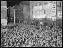
Willis Street
 Willis Street, looking south from its intersection with Mercer Street | |
| Namesake | Arthur Willis, New Zealand Company director.[1] |
|---|---|
| Maintained by | Wellington City Council |
| Length | 1.3 km (0.81 mi) |
| Location | 41°17′19″S 174°46′30″E / 41.288616°S 174.775014°E |
| North end | Customhouse Quay, Lambton Quay, Willeston Street |
| South end | Brooklyn Road, Nairn Street |


Willis Street is a prominent street in the central business district of Wellington, the capital city of New Zealand. Along with Courtenay Place, Manners Street and Lambton Quay, the lower reaches of Willis Street form part of the "Golden Mile", Wellington's primary entertainment and retail district.[2]
Willis Street is one of the four 'quarters' of downtown Wellington, the others being centred on the Cuba Quarter, Courtenay Place and Lambton Quay.
The two tallest buildings in Wellington, the Aon Centre (Wellington) (formerly known as BNZ Tower) and the Majestic Centre, are both located on Willis Street. There is a large number of heritage buildings registered by Heritage New Zealand in Willis Street, including St John's Church[3] and Henry Pollen House.[4]
References[edit]
- ^ "Streets of my city". www.wcl.govt.nz. Retrieved 26 March 2022.
- ^ "Transforming the Golden Mile is one step closer » Let's Get Wellington Moving". lgwm.nz. Retrieved 26 March 2022.
- ^ "St John's Church". New Zealand Heritage List/Rārangi Kōrero. Heritage New Zealand. Retrieved 12 March 2016.
- ^ "Henry Pollen House". New Zealand Heritage List/Rārangi Kōrero. Heritage New Zealand. Retrieved 5 March 2016.
