
Wikipedia:Graphics Lab/Map workshop/Archive/Mar 2019
| This page is an archive. Do not edit the contents of this page. Please direct any additional comments to the current main page. |

Minor map error
-
 Map of Gladstone in Henderson County, Illinois

- Article(s)
- Gladstone, Illinois
- Request
- Maps of this sort generally depict a specific location by highlighting it in red, and if it's small enough, the location is circled in red. Unfortunately, this one has the wrong location circled: the circle's placed around Biggsville, Illinois instead. (If you glance at the Biggsville map, you'll see that it's properly circled.) Could the circle be moved from Biggsville to Gladstone? It would be a trivial copy/paste in a PNG, but I don't know much about the workings of SVG. Nyttend (talk) 21:51, 2 February 2019 (UTC)
- Discussion
 Done. It's a fairly trivial edit in SVG as well, it just requires a vector editor like Inkscape, Karbon, or Adobe Illustrator. --AntiCompositeNumber (talk) 15:08, 3 March 2019 (UTC)
adding Mexican state boundaries to world map
Same-sex marriage laws (vary state-to-state in Mexico)
- Article(s)
- Marriage
- Same-sex marriage
- Same-sex union legislation
- Civil union
- Request
- Mexican states have different laws and so are colored differently. The current hand-drawn borders are rather crude. Would it be possible to copy over the borders from another map? They don't need to be precise (they could and probably should be reduced to the resolution of the other borders on this map), but it would be nice if they were more accurate -- some of the states are barely recognizable. I tried doing this myself, but without knowing enough about map projections to calculate the proper center of rotation, it was rather hopeless. (Unlike the Indian reservations in the US, where I didn't need to worry about matching up with coastlines and could just skew to the local longitude line.)
- BTW, the unused states have been moved west off the edge of the map for future use as local laws change. But I suspect it would be best if we left them in place but set the opacity of the borders and fill of the unused states to zero, so the map could be updated with a text editor rather than using Inkscape. (Though I don't know about turning the pop-up labels off and back on. We don't need a pop-up label for a state there's no law for. Hovering over it should just produce 'Mexico' from the territory underneath. Is there a simple way to handle that in the code, like commenting it out? Or will tags automatically fail to display if a territory is made invisible?)
- The dots can be ignored for this request. They're for individual cities.
- If somewhere there is a version of the original map this was based on that has subnational boundaries, I could copy them over myself. -- — kwami (talk) 22:55, 6 March 2019 (UTC)
- Discussion
Updating map at Hague Convention on the Civil Aspects of International Child Abduction

At the article Hague Convention on the Civil Aspects of International Child Abduction, please change Guyana on the map to blue, because it acceded to the Convention in 2019. Source: [1] 2A02:2F01:53FF:FFFF:0:0:6465:51A0 (talk) 22:28, 6 March 2019 (UTC)
![]() Done — kwami (talk) 05:03, 7 March 2019 (UTC)
Done — kwami (talk) 05:03, 7 March 2019 (UTC)
Request maps of Columbia, Missouri MSA and CSA
{{resolved}}
-
 A map of the Columbia, Missouri metropolitan statistical area
 -
 A map of the Columbia-Moberly-Mexico combined statistical area


- Article(s)
- Columbia, Missouri, metropolitan area
- Columbia, Missouri
- Portal:Columbia, Missouri
- Missouri census statistical areas
- Request
- The United States Office of Management and Budget updated the definitions of statistical areas on September 14, 2018. This included a number of changes to Missouri statistical areas including the addition of two counties to the Columbia metropolitan area. There hasn't been a map of the CSA since it was created, leaving the articles woefully outdated. The maps should be of Missouri with counties highlighted. The MSA map should include the counties of Boone, Cooper, and Howard. The CSA map should include the counties of Boone, Cooper, Howard, Audrain, and Randolph. A dot or indicator of some kind on the city of Columbia in the middle of Boone County would be a nice touch. Thanks for your consideration. -- Grey Wanderer (talk) 23:36, 4 March 2019 (UTC)
- If it's helpful here[2] is the current CSA map. Grey Wanderer (talk) 14:05, 26 March 2019 (UTC)
- Discussion
- @Grey Wanderer: For now, here are two SVG maps with the requested highlights. Because it's a plaintext file, I need to figure out where Columbia would fall on the pixel map, then draw a dot. I will replace the older versions with dotted versions.
- Cheers, Mliu92 (talk) 14:01, 8 April 2019 (UTC)
- Hey thanks! These versions look great so don’t feel like you have to go the extra mile. If you want to though maybe this map will help? Grey Wanderer (talk) 02:15, 9 April 2019 (UTC)
Blasphemy law map update
-
 Blasphemy laws worldwide

- Article(s)
- Blasphemy law
- Request
- New Zealand to be greyed out due to rescinding the law -- Fixmaster (talk) 00:32, 11 March 2019 (UTC)
- Discussion
- @Fixmaster: Done AntiCompositeNumber (talk) 14:01, 18 March 2019 (UTC)
World Map showing IPv6 Deployment by Country
I would like to add a world map showing IPv6 deployment to the IPv6 article, but I cant work out how to do one myself. As a source the APNIC Labs report https://labs.apnic.net/dists/v6dcc.html could be used. It shows the percentage of Internet users by country who have been allocated an IPv6 address. Because home-Internet users may not use dual-stack, they may not make use of the IPv6 capability of their home-router, therefore there is a difference between IPv6 deployment and actual use.--DroidBishop (talk) 16:35, 18 March 2019 (UTC)
ATA Carnet countries map to be updated and developed
-
 Member countries of the ATA Carnet system

- Article(s)
- ATA Carnet
- Request
- The map on ATA countries is incomplete and not updated. The complete list of countries is noted here:Field of application per country. Note that some territories are not highlighted (for example the Faeroe islands, the Channel Islands, the French Overseas Territories and dependencies, Puerto Rico etc.) and Qatar is missing. Other countries have signed one of the 2 conventions but their ATA activity is not operational as of now (marked with * in the table) and should be coloured differently. Also, it would be nice to have a third colour for countries who have not signed any convention but due a customs union are involved in ATA (eg Monaco, Liechtenstein, Namibia, etc). The complete list of special cases is here Special application cases. Optional if clear: add thick border lines to delimit customs unions (EU, SACU, CH-Liechtenstein). I thank the community in advance. -- Cikkajes (talk) 15:42, 19 March 2019 (UTC)
- Discussion
Historical maps


- Article(s)
- War of the Spanish Succession
- 18th century
- Peace of Utrecht
- Request
- Hi, would it be possible for someone to modify the above historical maps? There are some minor factual errors. Oran (1509–1708), Ceuta and Melilla had been under Spanish control; Tunisia (Ottoman Tunisia, Beylik of Tunis) was an autonomous part of the Ottoman Empire; Crimea was part of the Crimean Khanate, which was a vassal state of the Ottoman Empire; the Danubian principalities (Moldavia and Walachia) were vassal states of the Ottoman Empire; the Kingdom of Scotland was an independent state until 1707. Thanks. -- Tobby72 (talk) 13:17, 24 March 2019 (UTC)
- Discussion
Commonwealth Games Map

- Article(s)
- Commonwealth Games
- Request
- Alright, with the conclusion of the 2018 Commonwealth Games last year, the above map could do with a few changes:
1) Gambia rejoined the CoN in March 2018 and participated in last year's Games, hence it should be changed back to red.
2) The city of Birmingham, England, is set to host the next Games in 2022, and thus should be marked as such.
3) Given that the city of Durban, South Africa, is no longer scheduled to host the 2022 Games, the marker for the city should be removed from the map, and South Africa itself changed from purple back to red, as it no longer qualifies as a country that has hosted or plans to host the Games (after all, Montreal and Cardiff were scheduled to host the cancelled 1942 and 1946 Games respectively, and yet neither are marked as such, hence Durban shouldn't be either).
Thanks. Snow Lion Fenian (talk) 19:12, 24 March 2019 (UTC)
- Discussion
Vectorized map
-
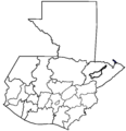 Map of Guatemala
 -
 Example


.svg)
- Article(s)
- 2019 Guatemalan general election
- Request
- Hi, one of you could vectorize the map of Guatemala. Please. Thank you. --Stalin990 (talk) 03:50, 27 March 2019 (UTC)
- Discussion
- @Stalin990: There's already a vectorised version at File:Guatemala Departments.svg. – Joe (talk) 06:38, 27 March 2019 (UTC)
- @Joe Roe: Thanks, in reality I need a map similar to the example of the map of Spain that I placed. Stalin990 (talk) 01:40, 28 March 2019 (UTC)