
Wikipedia:Graphics Lab/Map workshop/Archive/Jan 2014
Stale[edit]
Resolved[edit]
Update needed for File:Israel Railways map 2013.svg[edit]
-
 Map of Israel Railways currently used in the article.

Article(s): Israel Railways
Request:
- Please extend the red line one more station, labeled "Sderot" - see here for current official map. As any Hebrew speaker can see here on message #3, this station is already open. עוד מישהו Od Mishehu 05:45, 26 December 2013 (UTC)
Graphist opinion(s):
 Done Pretty self-explanatory, I've uploaded the file under the same name. Revert and let me know if something doesn't look right. —Mono·nomic 04:00, 30 December 2013 (UTC)
File:Extract_from_DoOS_1_to_50K_map_of_Jamaica_Sheet_G_1973_showing_course_of_Juan_de_Bolas_River.jpg The non-free image that is to be replaced.
Article(s): Juan de Bolas River
Request:
- A replacement is needed for the non-free image under discussion at Wikipedia:Non-free content review#File:Extract from DoOS 1 to 50K map of Jamaica Sheet G 1973 showing course of Juan de Bolas_River.jpg. I can supply by email a copy of all or part of the non-free map sheet if it is deleted as a result of the discussion. There is very partial coverage of the river atOpenStreetMap -- -Arb. (talk) 18:42, 3 December 2013 (UTC)
Graphist opinion(s):
- You have to tell me some more. Do you want this river added to an already existing map (then please provide it) or how do yo mean?
- I can do the graphic work but you have to give me more basic info. -Goran tek-en (talk) 19:48, 3 December 2013 (UTC)
- Thanks for the quick response. No suitable base map exists (to the best of my knowledge) so it would be a new map based on the extract linked above (File:Extract from DoOS 1 to 50K map of Jamaica Sheet G 1973 showing course of Juan de Bolas River.jpg). It would show the Juan de Bolas river in its drainage basin (so contours or coloured relief would be needed to give a sense of the relief) together with its tributaries and any other significant topography eg the roads, fords and largest settlements. Possibly with latitude and longitude graticules on the border if that fits Wikipedia's style. I will send you a slightly larger extract if you email me as the one linked above does not include the entire drainage basin out to the watershed (drainage divide) on every side. -Arb. (talk) 20:44, 3 December 2013 (UTC)
 Request taken by Goran tek-en (talk) 14:45, 4 December 2013 (UTC).
- At this time I'm not sure exactly on how to fulfill your request but I think we will find out together.
- I'm new here so I don't know how to email you, can't find a link or so on your talk page so please tell me how, thanks. -Goran tek-en (talk) 14:45, 4 December 2013 (UTC)
- Thanks for the quick response. No suitable base map exists (to the best of my knowledge) so it would be a new map based on the extract linked above (File:Extract from DoOS 1 to 50K map of Jamaica Sheet G 1973 showing course of Juan de Bolas River.jpg). It would show the Juan de Bolas river in its drainage basin (so contours or coloured relief would be needed to give a sense of the relief) together with its tributaries and any other significant topography eg the roads, fords and largest settlements. Possibly with latitude and longitude graticules on the border if that fits Wikipedia's style. I will send you a slightly larger extract if you email me as the one linked above does not include the entire drainage basin out to the watershed (drainage divide) on every side. -Arb. (talk) 20:44, 3 December 2013 (UTC)
@Arb: Finally I think I have found out which river you mean. It hasn't been all that easy with the little information you have provided.
Have a look at this link and see if it's the river next to the red line and give me feedback, thanks? --Goran tek-en (talk) 17:12, 3 January 2014 (UTC)
Mississippi Delta[edit]
► Philg88 ◄ ![]() talk 10:54, 23 January 2014 (UTC)
talk 10:54, 23 January 2014 (UTC)


Request. The only existing map of Mississippi Delta, above, is totally useless for showing where the region is located. Whould it be possible to produce a map showing the area in a proper identifiable context of the Southern US, with proper labelling of states, cities, rivers etc.? — Preceding unsigned comment added by86.128.5.150 (talk) 22:08, 14 December 2013 (UTC) Oh, and also a scale so's we can see how big the region is... — Precedingunsigned comment added by 86.128.5.150 (talk) 23:54, 14 December 2013 (UTC)
![]() Request taken by ► Philg88 ◄
Request taken by ► Philg88 ◄ ![]() talk 06:51, 16 January 2014 (UTC).
talk 06:51, 16 January 2014 (UTC).
- Done Note that the eastern boundary of the region does not appear to have an official definition. I have therefore based the border on information garnered from web sources and from a map of the alluvial floodplain of the Yazoo River (See the licensing page for the map at commons for details). ► Philg88 ◄
 talk 08:11, 18 January 2014 (UTC)
Kingdom of Georgia after fragmentation[edit]


Request:
- Please redraw first image into the format of SVG as it has in the second image by giving all kingdoms and principalities its borders but one green colour as it is in the second image.
- Please include only Kingdoms of Kartli, Kakheti and Imereti with Principalities of Guria, Svaneti,Abkhazeti, Samegrelo and Meskheti (Samzche should be written as Meskheti).
- Please include only these Georgian lands.
- Please do not include any more names but only the names of these 3 Georgian kingdoms and 5 principalities.
- Please do not include the neighboring states or lands.
Thank you. Jaqeli (talk) 10:25, 16 December 2013 (UTC)
- @Goran tek-en: Can you please if you can take my request as well? Jaqeli (talk) 18:44, 28 January 2014 (UTC)
![]() Request taken by Goran tek-en (talk) 18:58, 28 January 2014 (UTC).
Request taken by Goran tek-en (talk) 18:58, 28 January 2014 (UTC).
- I will take it but the next time you make an request please use the link above so all the code we need will be added, thanks. --Goran tek-en (talk) 18:58, 28 January 2014 (UTC)
- @Jaqeli: You gave me names in English I guess, but the map is in German so you will have to tell me which is which;
- Kartli = Kartlien
- Kakheti = Kachetien
- Imereti = Imeretien
- Guria = Gurien
- Svaneti = Swanetien
- Abkhazeti = Abchasien
- Samegrelo = ?
- Meskheti = Samzche but should be written as Meskheti
- You also wrote "Please include only these Georgian lands.". I'm sorry but this is your subject and not mine so I don't really know which those are but I will only include the eight as above.
- The map is already a svg map but with a bitmap image included so I will remove that. --Goran tek-en (talk) 19:17, 29 January 2014 (UTC)
- @Goran tek-en: Samegrelo = Mingrelien. Please just include only those. Jaqeli (talk) 19:30, 29 January 2014 (UTC)
- @Jaqeli: You gave me names in English I guess, but the map is in German so you will have to tell me which is which;
- I will take it but the next time you make an request please use the link above so all the code we need will be added, thanks. --Goran tek-en (talk) 18:58, 28 January 2014 (UTC)
@Jaqeli: Now you can look at a draft, (it takes some time to load) and give me feedback on it.
When it's Done I need;
- Name of the file
- Description
- Category/ies
to be able to upload it, thanks. --Goran tek-en (talk) 14:37, 30 January 2014 (UTC)
- @Goran tek-en:
- Name of the file - Kingdom of Georgia after dissolution as a unified state, 1490 AD
- Description - same as above.
- Category - Maps of Georgia
- And please write on Kartli, Kakheti and Imereti its name "Kingdom of".
- Kingdom of Kartli, Kingdom of Kakheti, and Kingdom of Imereti.
- Thanks again. Jaqeli (talk) 17:46, 30 January 2014 (UTC)
Now you can find it here Kingdom of Georgia after dissolution as a unified state, 1490 AD
![]() Done
Done
- @Goran tek-en: Many thanks again. Jaqeli (talk) 19:22, 30 January 2014 (UTC)
Erroneous map[edit]

Article(s): Organisation Africaine de la Propriété Intellectuelle
Request:
- Somebody pointed out here that the map shown on the page Organisation Africaine de la Propriété Intellectuelle is incorrect. Indeed, the map appears to be wrong. Could you help correcting the map? In particular, Dem Rep of Congo (Kinshasa) should not be in cyan. Thanks. --Edcolins (talk) 19:33, 19 December 2013 (UTC)
- In fact, the green countries are those with an ARIPO observer status. All the green coloured countries could be removed. --Edcolins (talk) 19:37, 19 December 2013 (UTC)
Graphist opinion(s):
If you specify exactly what changes are needed, I can do it. You specify one change "in particular" – what others are there? And what do you mean by "removed"? – set to the same grey as Australia? Maproom (talk) 10:19, 23 January 2014 (UTC)
- Yes, I should have been clearer: the green countries are to be set to the same grey as Australia, and the Dem Rep of Congo (Kinshasa) should be in grey as well. That's all. Thanks. --Edcolins (talk) 20:28, 23 January 2014 (UTC)
![]() Done Very easy, once I knew what was wanted. Maproom (talk) 23:58, 23 January 2014 (UTC)
Done Very easy, once I knew what was wanted. Maproom (talk) 23:58, 23 January 2014 (UTC)
(Comment from uninvolved editor) There is still a problem with this map - it shows Sudan as a member and it is not listed in the article as such. The new(ish) border between Sudan and South Sudan is also missing. ► Philg88 ◄ ![]() talk 16:42, 24 January 2014 (UTC)
talk 16:42, 24 January 2014 (UTC)
- ARIPO member states are in blue, and Sudan is a member state of ARIPO. This is correct. But, indeed, there are two additional corrections needed:
- South Sudan should be in grey.
- the Republic of the Congo should be in cyan (as an OAPI member state).
- Thanks! ...and sorry for not being complete from the outset. --Edcolins (talk) 11:36, 25 January 2014 (UTC)
EU location map[edit]
I made an SVG version available
-
 First map
 -


Request: Help converting the other countries by using the same licensing information. --David Liuzzo04:16, 20 December 2013 (UTC)
![]() Done
Done
- Done all the countries of the EU. Wereldburger758 (talk) 08:22, 23 December 2013 (UTC)
- FWIW, this looks like a mercator projection, in which case the map (especially the "whole world" map) will eventually need to be changed to a different projection. 111.69.100.9 (talk) 08:27, 7 January 2014 (UTC)
- There is a problem with these maps. They do not show many parts of Europe:
- Svalbard (a part of the EEA, seed bank is there, as well as research stations) is not visible at all
- Novaya Zemlya and Franz Joseph Land are not visible either
- European parts of Georgia (signed association agreement with the EU) and Armenia (Eastern partnership)
- Malta is not semi-lit (EU member) — Preceding unsignedcomment added by 89.128.236.143 (talk) 19:03, 8 January 2014 (UTC)
South China Sea[edit]

Article(s): South China Sea
Request:
- fix colors and borders per talkpage discussion... -- Kintetsubuffalo (talk) 03:16, 21 December 2013 (UTC)
Graphist opinion(s):
- Request taken by Goran tek-en (talk) 19:01, 22 December 2013 (UTC). I will make it into a svg file so it can be updated more easily. I will need help with colors and so on when I have a draft of it so check here. --Goran tek-en (talk) 19:01, 22 December 2013 (UTC)
 Question: Which talkpage, would be great with a direct link so I don't have to look for it but can concentrate on the graphic part. --Goran tek-en (talk) 13:13, 26 December 2013 (UTC)
- @Kintetsubuffalo:You can find a first draft here but I still need to know what you want more to be added or changed. Answer my question above please and give me feedback, thanks. --Goran tek-en (talk) 17:30, 26 December 2013 (UTC)
- Sorry again about getting back so late. The discussion is at https://en.wikipedia.org/wiki/File_talk:South_China_Sea_claims.jpg , and when I click your link, I get a 404 error. Thanks!--Kintetsubuffalo (talk) 07:51, 13 January 2014 (UTC)
@Kintetsubuffalo: I need your feedback as below if you want me to be able to complete your request, thanks.
look at this draft --Goran tek-en(talk) 16:59, 17 January 2014 (UTC)
- Thanks and sorry for the link, it's working now so please give me feedback. --Goran tek-en (talk) 10:46, 13 January 2014 (UTC)
(Comment from uninvolved editor) I suggest that it should be "Nautical" rather than "Nautic" in the title block. ► Philg88 ◄ ![]() talk 06:29, 16 January 2014 (UTC)
talk 06:29, 16 January 2014 (UTC)
- Thanks --Goran tek-en (talk) 17:02, 17 January 2014 (UTC)
- It looks good thus far.
I would put the competing claims in to illustrate.Thank you so much for your hard work!--Kintetsubuffalo (talk) 23:56, 17 January 2014 (UTC)- If you want me to put in anything else there you have to provide me with that information in some way.
- So is it Done now and if so should I upload it as a new version of the previous version? --Goran tek-en (talk) 15:50, 18 January 2014 (UTC)
- Surely the Red line is China's claim and the blue lines are the UNCLOS lines? It would also be useful to clarify the UNCLOS lines do not take the disputed islands into account. CMD (talk) 20:02, 19 January 2014 (UTC)
- Thanks for finding my mistake. That is now corrected and text is added to clarify the islands.
- look at this new draft, is it done now? --Goran tek-en (talk) 20:22, 19 January 2014 (UTC)
- Thanks for finding my mistake. That is now corrected and text is added to clarify the islands.
- Surely the Red line is China's claim and the blue lines are the UNCLOS lines? It would also be useful to clarify the UNCLOS lines do not take the disputed islands into account. CMD (talk) 20:02, 19 January 2014 (UTC)
- If you want me to put in anything else there you have to provide me with that information in some way.
@Kintetsubuffalo: I have now uploaded the latest svg version and you can find it here, South China Sea vector. If anyone need any changes just contact me, thanks. --Goran tek-en (talk) 14:48, 23 January 2014 (UTC)
![]() Done
Done
Change Mesopotamia image map from Deutsch to English.[edit]
-
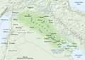 Map of Mesopotamia in Deutsch.

Article(s): Mesopotamia
Request:
- Change Mesopotamia image map from Deutsch to English. -- wildboy211 (talk) 01:38, 29 December 2013 (UTC)
Graphist opinion(s):
- If you want any of us to do this work you would have to provide us with a text file with all of the words translated, Deutsch to English. We do graphic work not translations or other research work, thanks. --Goran tek-en (talk) 13:41, 29 December 2013 (UTC)
@Maproom and Wildboy211: As I wrote before, if you provide me with that text file I can do a svg version based on a map of what we already have Mesopotamia svg maps but you have to get back directly to me as Page watch doesn't work all the time for me. --Goran tek-en (talk) 16:44, 24 January 2014 (UTC)
- @Maproom and Wildboy211: Now I have made vector (svg) versions as drafts of both the German and the English maps.
- Because the svg-file is so big (size) I have also made png versions to look at. This because to look at the hole svg versions you probably have to download it and open it in Inkscape or similar and I don't know if you use that type of programs.
- english svg
- english png
- german svg
- german png
- Have a look at them and give me feedback, thanks. --Goran tek-en
(talk) 18:02, 27 January 2014 (UTC)
- I am impressed! I would have had no idea at all how to achieve the SVG conversion.
- I have two items of feedback.
- I ignored the city names, thinking they would all be the same in German and English. But now I realise that German "Bagdad" is "Baghdad" in English. I'm sorry I missed that.
- I see that the macron over the "a" of "Zagros Gebirge" is still there. In the Swedish version it is still over the "a", where it does no harm. In the English version it looks a bit like a hyphen. But really, no-one is likely to notice it. Maproom (talk) 23:35, 27 January 2014 (UTC)
- @Maproom and Wildboy211: I have corrected our mistakes now (both) and uploaded the two versions;
- Thanks for the cooperation. --Goran tek-en (talk) 11:47, 28 January 2014 (UTC)
- I have two items of feedback.
![]() Request taken by Goran tek-en (talk) 19:55, 24 January 2014 (UTC).
Request taken by Goran tek-en (talk) 19:55, 24 January 2014 (UTC).
![]() Done
Done
Small changes to the map at Second Optional Protocol to the International Covenant on Civil and Political Rights[edit]
Could somebody update the map from the article Second Optional Protocol to the International Covenant on Civil and Political Rights?
This map:
https://en.wikipedia.org/wiki/File:ICCPR-OP2-map.PNG
- Latvia, Mongolia, Bolivia, Benin, Guinea-Bissau should be dark green
- Madagascar, Angola should be light green
Here is the source: https://treaties.un.org/Pages/ViewDetails.aspx?src=TREATY&mtdsg_no=IV-12&chapter=4&lang=en
2A02:2F0A:508F:FFFF:0:0:BC1A:B5B6 (talk) 19:35, 4 January 2014 (UTC)
![]() Done
Done
Many-banded krait distribution map[edit]
-
![Use this blank map to make the range of the species based on this [1]](//upload.wikimedia.org/wikipedia/commons/thumb/c/c4/Map_of_Asian_states.png/120px-Map_of_Asian_states.png) Use this blank map to make the range of the species based on this [1]
Use this blank map to make the range of the species based on this [1]
![Use this blank map to make the range of the species based on this [1]](./wiki.php?slug=File:Map_of_Asian_states.png)
Article(s): Many-banded krait
Request:
- Use a colour you think is most appropriate for a map of this kind. Nothing very bright, please. --DendroNaja (talk) 18:24, 6 January 2014 (UTC)
![]() Done
Done
Graphist opinion(s):
Giving Victims a Voice key offence locations from report figure 1 as reported by BBC[edit]
-
Key offence locations from report figure 1, as summarised in January 2013 by the BBC
-


Article(s): Giving Victims a Voice
Request:
- Free (preferably SVG) equivalent of map at [2] (based onpg 13 of the report), to replace the non-free upload. I suspect that commons:File:England police areas map.svg would provide a good starting point. Thanks for reading. -- Trevj (talk · contribs) 15:58, 7 January 2014 (UTC)
Graphist opinion(s):
![]() Request taken by ► Philg88 ◄
Request taken by ► Philg88 ◄ ![]() talk 16:53, 14 January 2014 (UTC).
talk 16:53, 14 January 2014 (UTC).
- Thanks very much. I'll keep an eye open here for comments as things move on, but please feel free to contact me via user talk if you wish. Cheers. -- Trevj (talk ·contribs) 17:59, 14 January 2014 (UTC)
- Comment This is going to take a bit longer than I anticipated - the SVG you suggested crashes Illustrator (and my PC grrr...). I found another similar base map (United Kingdom police areas map.svg) and whilst I can load it the file is corrupt such that I need to redraw some of the coastlines from base data. I assume that both these SVGs were created in Inkscape and that Illustrator doesn't like their SVG format for some reason. None of this is a show stopper and I'll continue working on it. Please check back here in a couple of days. Best,► Philg88 ◄ talk 08:17, 15 January 2014 (UTC)
- What a pain, but there's no rush so it doesn't bother me. I wonder whether loading and re-saving from a newer version of Inkscape would perhaps give a more compatible file. I had a quick look on the Inkscape forum but didn't find much which appears to be current advice. If the other file turns out to be less appropriate, I can investigate the file format issue with the first one and you can come back to it later if I get anywhere with it. Cheers. -- Trevj(talk · contribs) 08:33, 15 January 2014 (UTC)
- In fact, if the 2011 version of United Kingdom police areas map.svgexhibits the same issues, then a re-save of the other file might do it. -- Trevj(talk · contribs) 08:39, 15 January 2014 (UTC)
- What a pain, but there's no rush so it doesn't bother me. I wonder whether loading and re-saving from a newer version of Inkscape would perhaps give a more compatible file. I had a quick look on the Inkscape forum but didn't find much which appears to be current advice. If the other file turns out to be less appropriate, I can investigate the file format issue with the first one and you can come back to it later if I get anywhere with it. Cheers. -- Trevj(talk · contribs) 08:33, 15 January 2014 (UTC)
- Comment This is going to take a bit longer than I anticipated - the SVG you suggested crashes Illustrator (and my PC grrr...). I found another similar base map (United Kingdom police areas map.svg) and whilst I can load it the file is corrupt such that I need to redraw some of the coastlines from base data. I assume that both these SVGs were created in Inkscape and that Illustrator doesn't like their SVG format for some reason. None of this is a show stopper and I'll continue working on it. Please check back here in a couple of days. Best,► Philg88 ◄
![]() Done No problem, it took less time than I initially thought. I've redrawn some of the coastline based on what was missing. The file I've uploaded is in PNG format, largely because I know from experience that the Wikipedia SVG engine won't render the text inside boxes correctly, even though the fonts are open source and can be embedded in the SVG. I don't think PNG will be a problem - the map is 150 DPI and will scale satisfactorily. Take a look and let me know what you think - and please check the numbers! Best, ► Philg88 ◄
Done No problem, it took less time than I initially thought. I've redrawn some of the coastline based on what was missing. The file I've uploaded is in PNG format, largely because I know from experience that the Wikipedia SVG engine won't render the text inside boxes correctly, even though the fonts are open source and can be embedded in the SVG. I don't think PNG will be a problem - the map is 150 DPI and will scale satisfactorily. Take a look and let me know what you think - and please check the numbers! Best, ► Philg88 ◄ ![]() talk 14:23, 15 January 2014 (UTC)
talk 14:23, 15 January 2014 (UTC)
- Wow! Thanks very much. I've checked the numbers and not spotted any discrepancies. A few of the borders differ but that's down to the base information being inconsistent, with the only significant potentially misleading result I spotted being for South Wales. It looks as though the Commons map points to something nearer Monmouthshire than an amalgamation of Rhondda Cynon Taf and Bridgend County Boroughimplied by the report map (my geography of that area isn't great, so I referred to local government in Wales). The situation isn't helped by police areas straddling local government areas in places!
- So your thoughts on that would be appreciated.
- As for the text rendering, if you think that there could possibly be an effective way to address this in the future (in order to more easily facilitate the adaptation into versions for other languages), then it may be worth adding {{Convert to SVG}}, but I'll leave that up to you.
- Cheers. -- Trevj (talk ·contribs) 15:52, 15 January 2014 (UTC)
I downgraded the SVG spec and it renders fine (see above) - I have overwritten the PNG version. I have also fixed the South Wales issue - the callout previously pointed to Gwent - caused by a disparity in the report map and the police area map. Should be good to go now. Please mark as {{resolved}} in the section header. Best, ► Philg88 ◄ ![]() talk 16:42, 15 January 2014 (UTC)
talk 16:42, 15 January 2014 (UTC)
A few maps required[edit]
-
Description of first image
-
Description of second image (if needed)
-
Description of third image (if needed; don't request too many at once, though)
Article(s): [[]]
Request:
- Details of your request go here... -- 89.128.236.143 (talk) 18:40, 8 January 2014 (UTC)
Graphist opinion(s):
Articles: Globalisation index, Social Progress Index, Web index, Space Competitiveness Index, EF English Proficiency Index, Global peace index, Global Terrorism Index ![]() Done
Done
Request:
- Using these articles with there source:
- Globalisation index(http://globalization.kof.ethz.ch/media/filer_public/2013/03/25/rankings_2013.pdf) Done
- Social Progress Index (http://www.socialprogressimperative.org/data/spi) Done
- Web index (http://thewebindex.org/) Done
- Space Competitiveness Index
 Not done (I am not spending money to find the results of the Index.-User:Spesh531)
 - EF_English_Proficiency_Index Done
- Global_peace_index (the map exists but needs updating to the year 2013:http://www.visionofhumanity.org/pdf/gpi/2013_Global_Peace_Index_Report.pdf) Done
- Global_Terrorism_Index (needs a map: http://economicsandpeace.org/research/iep-indices-data/global-terrorism-index) Done
- Globalisation index(http://globalization.kof.ethz.ch/media/filer_public/2013/03/25/rankings_2013.pdf)
- Is this page active at all???--89.128.236.143 (talk) 13:25, 10 January 2014 (UTC)
- It is, but there aren't as many volunteers here as we'd like, so the requests which are understandable, and not just a mess of half-edited templates with no easily discernible requirement tend to get looked at in preference. Perhaps you might take a little time to be clearer about what you'd like, and someone might be able to tell you if it's feasible, and guide you as to what work you'd need to do yourself to help us achieve that. Not trying to be difficult, but when I see a spaghetti request like this I tend to just look at the next one. No offence, I hope, but on a busy page, with few volunteers, effort from the requester tends to earn effort in response.
- It's understandable that you might not easily follow the templates or the formats here, and if that's the case a little prose explaining what you're after would go a long way, and we could fix the rest. Also, you used more question marks there (3) than you waited days (2) ... Just saying... Begoon talk 17:14, 14 January 2014 (UTC)
- Is this page active at all???--89.128.236.143 (talk) 13:25, 10 January 2014 (UTC)
Update[edit]
-
 2012 World Map of the Index of Economic Freedom

Article(s): Index of Economic Freedom, Indices of economic freedom, List of countries by economic freedom, List of freedom indices
Request:
- To update the World Map of economic freedom to show the 2014 indicies published by the Heritage Foundation and Wall Street Journal. The indicies and heat map can be found (http://www.heritage.org/index/heatmap) and (http://www.heritage.org/index/ranking). Thank you. --pipeafcr (talk) 16:45, 17 January 2014 (UTC)
Graphist opinion(s):
- @Pipeafcr: I think you have to be a bit more specific than that, anyway if I will do it.
- On this link (http://www.heritage.org/index/heatmap) you can choose from 11 different categories, which do you want or do want it as it is before you make any selections?
- Then on this link (http://www.heritage.org/index/ranking) the countries are divided into different groups which have colors that you could use, but is that the same data as the other link or how should it be used?
- I have not the knowledge of where all those countries are located so if I can use only the first links map I can do a vecter version which will be much easier to update in the future. So get back to me, thanks. --Goran tek-en (talk) 16:14, 24 January 2014 (UTC)
- @Goran tek-en: Goran tek-en Thank you for taking on this project! Indeed there are 11 other different categories on the but those are for different map subjects that have already been updated so please use the 6 subject reference (Free, Mostly Free, Moderately Freely, Mostly Unfree,Repressed & Unranked). You may indeed use the the first link map but please do be as accurate as possible. Good luck and don't hesitate to contace me again if you have more questions.--pipeafcr (talk) 16:32, 25 January 2014 (EST)
![]() Request taken by Goran tek-en (talk) 13:25, 26 January 2014 (UTC).
Request taken by Goran tek-en (talk) 13:25, 26 January 2014 (UTC).
- Now you can have a look at this draftand give me feedback on it, thanks.
- Now you can have a look at this draftand give me feedback on it, thanks.
- Eventually I will also need;
- Name of the file
- Description
- Category/ies
- to be able to upload it. --Goran tek-en (talk) 18:57, 29 January 2014 (UTC)
- Eventually I will also need;
- Wow, the map looks great and just how I was expecting it to look. I only found a little problem and that was that Serbia was marked as being "moderately free" but it's "Moderately Unfree" so that will need to be changed but overall, it looks A plus.
- We can use the following;
- "2014 World Map of the Index of Economic Freedom" for name of the file
- "2014 index of economic freedom according to The Heritage Foundation and The Wall Street Journal" for the description
- Freedom Indicies and Index of Economic Freedom can be used for the Category/ies
- Thanks a lot! --pipeafcr (talk) 19:37, 29 January 2014 (EST)
- You mean Not ranked I guess? Because that was what the image gave.
- Now it's uploaded here 2014 World Map of the Index of Economic Freedom and if you need any changes just contact me, thanks. --Goran tek-en (talk) 19:04, 30 January 2014 (UTC)
- You mean Not ranked I guess? Because that was what the image gave.
- We can use the following;
![]() Done
Done
Thank you so much, you may delete request as it's been marked as done now. — Precedingunsigned comment added by Pipeafcr (talk •contribs) 03:12, 1 February 2014 (UTC)
Pitcairn Island[edit]

Article(s): Pitcairn Island
Request:
- should just be "Gambier", no I at the end... -- Kintetsubuffalo (talk) 15:20, 21 January 2014 (UTC)
Graphist opinion(s):
Map creation[edit]
How do we create maps?--Fənɛ́tɪks.fərɛvər (talk) 06:54, 23 January 2014 (UTC)
- You are kidding, right? You could try the help sections linked above but as you are under investigation for sockpuppetry you might want to wait until that is over before venturing into maps. ► Philg88 ◄ talk 07:20, 23 January 2014 (UTC)
Map for article on Æthelred, Lord of the Mercians[edit]
-
 England in 878
 -
 England at the time of Æthelred c. 910


I have been working on Æthelred, Lord of the Mercians, the ruler of Mercia in the time of Alfred the Great, and I have amended the map which is currently on the article and created a new one at [3]. I am not sure how legible my writing is, but places I have added are Conwy, Much Wenlock, Buttington, Tettenhall, Gloucester, Berkeley, Risborough, Pyrton, Thorney. Welsh kingdoms: DYFED, GWENT, GLYWYSING. Many thanks if anyone can help. Dudley Miles (talk) 18:54, 28 January 2014 (UTC)
- Comment: I have a better map from around that time than the current one - let me dig it out and get back to you. Best ► Philg88 ◄ talk 19:01, 28 January 2014 (UTC)
- Many thanks. Dudley Miles (talk) 19:33, 28 January 2014 (UTC)
![]() Request taken by ► Philg88 ◄
Request taken by ► Philg88 ◄ ![]() talk 19:41, 28 January 2014 (UTC).
talk 19:41, 28 January 2014 (UTC).
- Comment: What about using the map shown above as a basis with a long/lat grid and scale added? I can then modify as per your pdf – I would propose "England at the time of Æthelred c. 900" as the file name and title. I look forward to your comments. ► Philg88 ◄ talk 19:41, 28 January 2014 (UTC)
- That looks fine. A couple of points. 1. I wrongly left in Guthrum Kingdom as he was dead by that time. I think East Anglia would be better. 2. English Northumbria would be better than the modern name of Northumberland. Many thanks. Dudley Miles (talk) 21:07, 28 January 2014 (UTC)
- No problem. I'm on it. ► Philg88 ◄ talk 06:20, 29 January 2014 (UTC)
![]() Done
Please see the gallery image above - I moved the year forward to 910 so that I could include the Battle of Tettenhall. Best, ► Philg88 ◄
Done
Please see the gallery image above - I moved the year forward to 910 so that I could include the Battle of Tettenhall. Best, ► Philg88 ◄ ![]() talk 11:29, 30 January 2014 (UTC)
talk 11:29, 30 January 2014 (UTC)
- That's brilliant. Many thanks. A few minor points. 1. Worcester and the north Welsh kingdom of GWYNEDD are missed out and Much Wenlock is spelled Much Wenlove(!) 2. The Battle of Tettenhall should be dated 910 and Edington 878. I am not sure it is necessary to show the names twice as the town and the battle but I defer to you if this is normal practice. 3. Should the Battle of the Conwy in 881 also be shown? It is named after the river rather than the town but it was probably fought near the town. 4. I prefer your original idea of dating the map c.900. 910 seems to me too specific, particularly as Æthelred is not known to have been active after 900 when his health probably collapsed. Dudley Miles (talk) 15:00, 30 January 2014 (UTC)
All changes that you suggest made and uploaded apart from the date, since that would mean that the Battle of Tettenhall can't appear although it is mentioned in the article. Best, ► Philg88 ◄ ![]() talk 16:37, 30 January 2014 (UTC)
talk 16:37, 30 January 2014 (UTC)
- That's great. I have inserted it into the article but it appears with right side cut off missing the 0 of 910. Can you advise how I solve this or is it something with my computer? Many thanks. Dudley Miles (talk) 17:13, 30 January 2014 (UTC)
This is a common problem and it's to do with the way the Wikimedia software renders the SVG graphic. When it shrinks the size to display it in an article it creates a .png that sometimes doesn't come out correctly. I'll have a fiddle and see if I can fix it otherwise the fall back position is to make it into a .png. I don't really want to do that as that defeats the object of creating a scalable non-raster based graphic. ► Philg88 ◄ ![]() talk 19:57, 30 January 2014 (UTC)
talk 19:57, 30 January 2014 (UTC)
- No need to make a fallback-png. There were some hidden, empty elements outside of the picture. Made the picture also ValidSVG, i.e. I removed the bloated code of Adobe Illustrator. Wereldburger758 (talk) 11:46, 31 January 2014 (UTC)
- Thanks very much. All fine now. Dudley Miles (talk) 11:57, 31 January 2014 (UTC)
- No need to make a fallback-png. There were some hidden, empty elements outside of the picture. Made the picture also ValidSVG, i.e. I removed the bloated code of Adobe Illustrator. Wereldburger758 (talk) 11:46, 31 January 2014 (UTC)
Many thanks for the cleanup Wereldburger758 - alas a file coming originally from Inkscape to Illustrator and back to SVG is an egregious thing to say the least! I tried to make it ValidSVG but the W3C validator said that the font families weren't complete or some such nasty. Cheers, ► Philg88 ◄ ![]() talk 12:01, 31 January 2014 (UTC)
talk 12:01, 31 January 2014 (UTC)
- Yes, I encountered the problem. Some font-styles were completely empty. After I selected them in the code, I discovered they were not there in the picture. Deleting them solved the problem. Wereldburger758 (talk) 12:15, 31 January 2014 (UTC)
Serbian Empire[edit]
-

-
 Draft 1 by Tobias!
 -
 Final png-version
 -
 Very ugly SVG version after one hour of trying to fix it in Inkscape and Illustrator (by Tobias)

.svg)

.svg)
Article(s): Serbian Empire
Request:
- Wikify, less garish colors, more information... -- Kintetsubuffalo (talk) 07:35, 23 September 2013 (UTC)
Graphist opinion(s):
- Request taken by Tobias1984.
- My first try to make a map here. Really suprised how it rendes on Wikipedia. Any suggestions how I can improve this? Also where can I find the names and coordinates of these ancient towns on the original map? --Tobias1984 (talk) 16:31, 4 October 2013 (UTC)
- Pretty good for a first try. Curious: from where does your background come from ? (>oh, naturalearthdata.org)
- You may add sea waters in blue, we have helpful guidelines there.
- It's funny to see that your prefer white-to-black reliefs. We have a toolbox for a green-to-brown-to-white scheme which is quite popular.
- Some tricks about the map workshop:
- use {I take|Tobias1984} to show that you take over a request,
- when you design your map with a GIS software, keep the WNES geo-coordinates (West/Norht/East/South). It allow geolocalisation.
- it is convenient to use a file naming convention such File:{Subject name in English} relief location map-{language}.svg, for you: File:Serbian_Empire_1355_CE_relief_location_map-en.svg. This naming scheme is within the our topographic toolbox. If you plan to fully complete the request, the final name is ok. Otherwise, you may add "~~(draft01).svg".
- when you upload this file to commons, then come back on the workshop and add it to the section's gallery with a comment like "Draft01 by Tobias!" so other cartographers see your work, may ask you question, and give you advices and graphic tricks.
- Hope these tricks are helpful. This map is nice, black-white scheme is ok too. Nice start ! Cheer up ! Yug (talk) 12:45, 5 October 2013 (UTC)
- Thanks for all the, indeed, very helpful advice. I will try to learn how to do the other colors. --Tobias1984 (talk) 16:08, 7 October 2013 (UTC)
- A new cartographer is born ! :D Yug (talk) 23:00, 8 October 2013 (UTC)
- ;) The only thing I still have to figure out which fonts to use for the SVG export and how to "keep the WNES coordinates". --Tobias1984 (talk) 05:50, 9 October 2013 (UTC)
- I generate the SVG relief, then I add text, legend, etc using the SVG toolbox which I deeply slaughter as needed : ] As for WNES in QGIS, I have no idea. I work directly with gdal now. We may find out by hand how to synchronize your and my layers, but naturally, if you have WNES values, my (or someone else's) output will perfectly match yours which will be better. Yug (talk) 11:53, 19 October 2013 (UTC)
- Pretty good for a first try. Curious: from where does your background come from ? (>oh, naturalearthdata.org)
For extracting the WNES boundaries from a Qgis project, I couldn't find an easy way to do this either - you'd think there would be for something so obvious, but if there is I can't find it. Here's what does work, though, and it only takes a few seconds to do:
- Open your project in Qgis, and make sure the area you require is displayed in the window.
- From the menu - select Project - Properties then click in the CRS tab.
- In the Coordinate reference system box - scroll up to Geographic Coordinate Systems, and pick AGD66 (probably 1st in list) Then click ok.
- now you can either carry on with points 4,5,6 etc or skip to (*) below...
- At the bottom of the screen click the toggle next to "Coordinate" or "Extent" until it says "Coordinate" - it might already, or you might need to toggle it
- Now as you roll your cursor across the screen you will see the coordinates in this box as it moves, so...
- By rolling your cursor "off" the N, S, W, E edges, the number will 'freeze' as it rolls off, allowing you to note the 4 extents - do it a couple of times on each edge to be sure you're reading it right.
- When you've got the 4 figures, close your project but don't save or you'll save the CRS changes, and you may not want to.
(*)...Now that's all a bit manual, so alternatively you can do points 1, 2, 3 only, then do File - Save As and save it as a copy on your desktop or somewhere in a file called "Temp.qgs" or similar. Open the temp qgs file in a text editor, and you'll see a section like:
<units>degrees</units>
        <extent>
            <xmin>13.30745349297591318</xmin>
            <ymin>2.41131646368804331</ymin>
            <xmax>94.73406229858925087</xmax>
            <ymax>55.48621329091184862</ymax>
        </extent>
which is the extents of your bounding box. It's important it says "degrees" - if it's in meters or something else you didn't change the CRS in points 1, 2, 3 correctly.
Just be sure you back up your project first (by copying its .qgs file somewhere, or saving it in a secondary backup location) before doing any of this and only save as copies, so you don't accidentally mess up any of your hard work... Begoon talk 12:27, 19 October 2013 (UTC)
- Tobias1984, these new maps are a pretty good work, far, far better than the former map ! So let's push these 2 maps forward. The labels on the west side may be move a bit inward, the files should be uploaded/moved to new name (File:Serbian_Empire_1355_CE_relief-bw-en.png for black & white, & File:Serbian_Empire_1355_CE_relief-en.svg for color, svg better for later translations), and include them in some articles. Do you have 'move rights' on commons ? (then I let you do) otherwise I go forward and do it. Note: I love these topographic maps @____@ Yug (talk) 10:39, 1 November 2013 (UTC)
- I put the png-version of the map into both articles that were using the old one. I couldn't get the QGIS-exported SVG to look nice. Everytime I fixed something another thing would look terrible. Inkscape had more troubles with the file than Illustrator, so I guess Commons renders more similar to Inkscape, because it looks a little better in Illustrator. --Tobias1984 (talk) 14:34, 5 November 2013 (UTC)
- Marking as resolved. Will take care of minor mistakes and continue discussion on my talk page. --Tobias1984 (talk) 10:36, 21 January 2014 (UTC)