
Viciana

Viciana (Latin: Viziana - Vizianum) or Station Viciano was a Roman road station (mansio type)[1] of unclear location, somewhere in Kosovo field.[2]
History[edit]
Viciana was a stopping place for caravans that travelled the Lissus–Naissus route, one of the most important Roman roads. The route started from Lezha (Lissus) on the Adriatic coast, went through the Drin river valley, crossed through Dardania, and continued to Niš (Naissus).[3]
The location is unclear. It has been theorized to have been somewhere in the Kosovo field or in the present-day city of Vushtrri or its surrounding areas.[4] In addition, approximately 4 km south of Vushtrri, in the village of Pestovë, there are the archaeological ruins of the Roman villa known as Vila rustica, Pestova (archaeological site).[1][5][6][7]
Viciano as a road station is recorded in the Tabula Peuntingeriana map, a medieval (15th century) map and copy of a 3rd-century Roman map showing this same itinerary. The road once passed near the ancient center of Municipium Ulpiana which connected it to other Roman towns, particularly mining centers rich in precious minerals.[8][better source needed]
Gallery[edit]
-
 The reproduction of a Roman inscription today is the cultural symbol of the city of Vushtrri.
 -
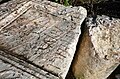 Archaeological findings of Roman inscriptions in Duboc Fortress near Vushtrri.
 -
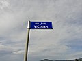 Sign of the Viciana street in Vushtrri


.jpg)
Tabula Peutingeriana[edit]

See also[edit]
References[edit]
- ^ a b Kraja, Mehmet, ed. (2018). "Fjalori Enciklopedik i Kosovës". (Encyclopedic Dictionary of Kosova) (in Albanian). Vol. 2. Prishtinë: Akademia e Shkencave dhe e Arteve e Kosovës. p. 1760. ISBN 9789951615846. OCLC 1080379844.
- ^ "Vushtrria city Vicianum is the Roman Vacations in Kosovo". www.kosovo-vacations.com. Retrieved 2024-02-18.
- ^ "History of Vushtrri". Official website of the Vushtrri Municipality. Retrieved 2024-02-18.
- ^ Swinburn, Gwen; Murphy, Fergus, eds. (2003). "LOCAL ECONOMIC DEVELOPMENT STRATEGIC PLANNING AND PRACTICE CASEBOOK" (PDF). p. 70.
- ^ Gjocaj, Zenun, et al., eds. (2003). Vushtrria - Viciana me rrethinë [Vushtrri - Viciana and its surroundings] (in Albanian). Prishtina: Kuvendi Komunal i Vushtrrisë (Municipal Assembly of Vushtrri). pp. 43–55. OL 27940463M.
- ^ Warrander, Gail; Knaus, Verena (2010). Kosovo: The Bradt Travel Guide. Bradt Travel Guides. p. 257. ISBN 9781841623313.
- ^ Domaszewski, A. (1889). „Die Grenzen von Moesia Superior und der Illyrische Grenzzoll“. Wien: Archäologisch-epigraphische Mitteilungen aus Österreich-Ungarn, XIII, 140–145.
- ^ Milot Berisha, Kosovo Archaeological Guide,Prishtinë, Kosovo Archaeological Institute and Ministry of Culture, Youth and Sports, 2012, Pg.72.
Sources[edit]
- Mikl-Curk, Iva (1980). Putevi i komunikacije u antici. Savez Arheoloških Društava Jugoslavije.
Further reading[edit]
- Exhlale Dobruna-Salihu, «Problem of the location of the station Viciano», Materijali arheoloskog dru$tva Jugoslavije, xvii, 1978 [publ. 1980], pp. 163–167. 15529.
- Zef Mirdita, «Probleme de la reconstruction du tracé de la route Vicianum-Gabu- ...