
User talk:Fay2
Welcome!
Hello, Fay2, and welcome to Wikipedia! Thank you for your contributions. I hope you like the place and decide to stay. If you are stuck, and looking for help, please come to the Wikipedia Boot Camp, where experienced Wikipedians can answer any queries you have! Or, you can just type {{helpme}} on your user talk page, and someone will show up shortly to answer your questions.
Here are a few good links for newcomers:
- The five pillars of Wikipedia
- How to edit a page
- Help pages
- Tutorial
- How to write a great article
- Manual of Style
I hope you enjoy editing here and being a Wikipedian! Please sign your name on talk pages using four tildes (~~~~); this will automatically produce your name and the date. If you need help, check out Wikipedia:Where to ask a question, ask me on my talk page. Again, welcome! Kukini 06:33, 5 February 2006 (UTC)
Map accuracy[edit]
While the map you added to Indiana Territory is in general a welcome addition, I have a few quibbles with some inaccuracies. I've described them a bit more in detail at Talk:Indiana Territory. Cheers. older ≠ wiser 14:34, 19 February 2006 (UTC)
Gascony map[edit]
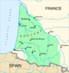
Hi, I just saw your Gascony map. The area you have highlighted as Gascony is too large, it includes areas that are not part of Gascony. Gascony does not extend beyond the Garonne river, so you should change the color of all territories east and north of the Garonne river. At the level of Toulouse, the border of Gascony is located approximately 15 miles west of the Garonne river. In the north the area of Bordeaux is included in Gascony by some people, but other consider that the area of Bordeaux is Guienne, distinct from Gascony. In the south, it is debatable whether the areas of Biarritz, Pau, Tarbes, and Luchon are part of Gascony. I suggest hachured green, rather than plain green, for these areas. Hardouin 11:17, 24 February 2006 (UTC)
The new map is much better, however I still see the following problems:
- the French Basque country is not part of Gascony, it shouldn't be hachured
- I think most people really consider the area of Bordeaux as not part of Gascony, so I suggest not to hachure it
- on the other hand, at the level of Toulouse the border of Gascony should be closer to the city of Toulouse
- in the south-east, there are some territories east of the Garonne River that should be hachured
This map ([1]) is very good and reflects all the four points I have mentioned above. There is only one problem with this map, the south-east border: look carefully on the map, between the Arize River (south of Toulouse) and Toulouse, I think it is incorrect to show the eastern bank of the Garonne as part of Gascony. What I would do: I would use the Garonne as the border all the way south to half way between the Arize river the Salat river, then from there I would run a line parallel these two rivers, right in the middle between these two rivers, till I reach a point half way between the town of St-Girons and the town of Foix, then from this point due south to the Spanish border. Do you follow me?
I also suggest some more minor changes:
- separate a bit more the name "Toulouse" and the name "Auch"
- add the town of Mont-de-Marsan
Finally, there is the problem: where to start the hachured area in the south. Here use this map ([2]), the northern borders of départements 64 and 65 should be the limit between plain and hachured (except the sort of finger in the north west of département 65 which should be plain). Then for département 31 it's even more complicated. What I would do is I would use plain color from west to east till I reach a line about 15 miles west of the Garonne river, then hachured from this line to the Garonne river. This applies only south of Toulouse. North of Toulouse it is plain all the way till the Garonne.
Complicated isn't it? Let me know what you come up to. Hardouin 17:31, 24 February 2006 (UTC)
- To help you out, here is approximately where I would put the limit plain/hachured in département 31.
File:TempGasc.PNG Maybe the limit would be even closer to the Garonne river. I'm not sure exactly how large is 15 miles on your map. Hardouin 17:47, 24 February 2006 (UTC)
- Ok, I had a look at your new map. I think you should leave the southern areas hachured, instead of giving them a third shade of green, which is confusing. Also, please insert the map in a larger map of western Europe as you did originally. Also, I think you should leave the cities that you labelled on the map the first time. Finally, in the southeast I think the border should be a bit closer to the Garonne River (from what I can tell of the scale of your map). Let me know when you're done with the changes. Hardouin 18:41, 26 February 2006 (UTC)
- Yes, it looks pretty good now. My only suggestion is this: don't show a black line between plain green (the green of Gascony) and hachured green (on your first version of hachured there was no black line, like on the map above, I think it's better). Also, show the hachured area on the larger western Europe map as well. Apart from that I see nothing else to say. Hardouin 21:10, 26 February 2006 (UTC)
- Actually, now that I am thinking about it, it's better to remove all black lines altogether. There are no definite borders of Gascony, the concept of boundary didn't exist in the Middle Ages, so better just leave the green colors, but no black boundary, like on the map above. Hardouin 21:13, 26 February 2006 (UTC)
- Of course the modern day border of Spain should remain as a black line, but all other black line borders I suggest you remove. Hardouin 21:15, 26 February 2006 (UTC)
- You uploaded the original version of the map. Unless there's a problem with Wikipedia... Hardouin 21:45, 26 February 2006 (UTC)
{{TACKLEHUG}}[edit]
Your historic regions maps are BEAUTIFUL. Keep up the great work!!!! jengod 00:05, 28 February 2006 (UTC)</nowiki>
Dropkick Murphys[edit]
Please discuss on the talk page before reverting the so-called "blanking". 65.78.8.9 20:33, 4 March 2006 (UTC)
New maps[edit]
Could you create a map for the Thirteen Colonies, like the U.S. territory maps you did? Rmhermen 15:49, 10 March 2006 (UTC)
- If you are looking for a bigger challenge: Oregon boundary dispute is looking for a better map which requires competing claims to be marked on one map, somewhat like your Indiana territory map. Rmhermen 18:32, 10 March 2006 (UTC)
Hello[edit]
Hi, I'm from Indonesia, and I want to make several maps about Indonesian regency division map as well as its locator map. I know little about ESRI's ArcView, but I have no idea about an artistic map :) Could you help me please to make a BEAUTIFUL map? If so, what should I do? What kind of materials shall I send to you? Thanks before. Wic2020 05:11, 11 March 2006 (UTC)
Psst[edit]
Please check out this page. Pass it on! — Catherine\talk 01:50, 13 March 2006 (UTC)
Map request[edit]
Hello, fellow UW Wikipedian. I see that you know some Spanish and that you like to make maps, so I thought, why not ask you to make a map for a page that I created (Linguistic history of Spanish). It has some nifty charts, but as yet, no pictures or maps. I'd like to show the spread of Castilian through the Iberian Peninsula. Let me know if you're up to the challenge. And hey, now that school's out, maybe it'll be a fun summer project.--Hraefen 20:36, 23 May 2006 (UTC)
- I will have all my ducks in a row by the end of August and then we can figure out how to coordinate. Let me know when you're ready.--Hraefen 20:21, 24 May 2006 (UTC)
Map Request (Alaska+Yukon)[edit]
In my search for a skilled Wikipedian Cartographer your user name has come up many times. I was wondering if you would be interested in a map of the State of Alaska and the Territory of the Yukon together as if they were one unit. It would not have to be anything fancy just an image of all of Alaska and Yukon together as one shaded unit. I am not sure if it is possible to show everything but if it were possible that would be awesome. Thank you. Emperor 03:20, 26 May 2006 (UTC)
Regarding editing maps...[edit]
- Now you mention it, there is a problem with the Wisconsin Territory map. The portion of the Wisconsin Territory forming the Arrowhead Region of Minnesota ought to be given another shade of green and labled as "1836-1849" since not all of Wisconsin Territory became the State of Wisconsin. During that one-year period, Wisconsin Territory consisted of two counties: La Pointe County, Wisconsin and St. Croix County, Wisconsin. This was problematic at first since St. Croix County's seat was Stillwater, and the State's county's seat was out of state, but the territorial county kept Stillwater as its seat while the state's county made Hudson, Wisconsin its seat. Because of government functions already established in Stillwater, the Minnesota Territory convention was first held there. For that matter, probably Iowa Territory map should also be adjusted to the portion that became the state marked "1838-1846" and the rest as "1838-1849". CJLippert 22:41, 25 July 2006 (UTC) (moved my comments to here CJLippert 19:18, 31 July 2006 (UTC))
- The fixed WI-Terr/IA-Terr maps look great! Thanks. But I was thinking... what was the NW boundaries of NW-Terr, IN-Terr/IL-Terr/Mi-Terr before the Treaty of 1818? My impression was that it was only with that treaty that the NW corner went from the mouth of Lake Itasca to the 49th parallel, forming the Northwest Angle. Before 1818, the boundary might have been undefined, but people generally claimed Rupert's Land as the area not of the Missouri River, Mississippi River or Lake Superior basins, with the Mississippi River then dividing the Northwest Territory from the Louisiana Territory. However, there digital copies of old maps on the internet, as late as 1836, showing that watershed boundary instead of the 1818-established straight-shot line boundary. Could you check on that and if needed, adjust the maps for the parental territories of Wisconsin Territory?
Also, I recall something about the WI boundaries went from Thompson Rapids south to the St. Croix River and when Minnesota became a state, it litigated Wisconsin to have the boundaries moved to the "first rapids of the Saint Louis River", which Minnesota argued was Fond du Lac Rapids and not Thompson Rapids (which is the first major rapids of the Saint Louis River), and had the land boundary moved about 3.5 miles east to its present location... but I can't quite find confirming records, though I have read it somewhere (and I can't remember where... bummer).CJLippert 06:23, 2 August 2006 (UTC) (Strike-through: nevermind. I'm getting the past WI/MN boundary issue confused with WI-Terr/MN-Terr, though probably wouldn't be visible difference between the WI/MN-Terr boundary versus the WI/MN boundary, unless there is a zoom-in to that area between the St. Croix and St. Louis Rivers. CJLippert 16:21, 2 August 2006 (UTC))- Oh, I just thought of two other minor details. For the Wisconsin Territory map, there should be a piece located currently in the Upper Peninsula Michigan that should be part of WI-Terr marked "1836-1837" from when the newly formed MI nibbled away at WI-Terr to the current UP-MI/WI border. In addition, wasn't there a piece of Minnesota Territory that went "unorganized" in the years 1858-1861 until it was incorporated into the Dakota Territory? CJLippert 16:39, 2 August 2006 (UTC)
- The fixed WI-Terr/IA-Terr maps look great! Thanks. But I was thinking... what was the NW boundaries of NW-Terr, IN-Terr/IL-Terr/Mi-Terr before the Treaty of 1818? My impression was that it was only with that treaty that the NW corner went from the mouth of Lake Itasca to the 49th parallel, forming the Northwest Angle. Before 1818, the boundary might have been undefined, but people generally claimed Rupert's Land as the area not of the Missouri River, Mississippi River or Lake Superior basins, with the Mississippi River then dividing the Northwest Territory from the Louisiana Territory. However, there digital copies of old maps on the internet, as late as 1836, showing that watershed boundary instead of the 1818-established straight-shot line boundary. Could you check on that and if needed, adjust the maps for the parental territories of Wisconsin Territory?
Regarding the boundary between Wisconsin Territory and the UP, I left comments at Talk:Wisconsin Territory and on the map's Image talk page. The boundaries between Wisconsion Territory and the UP as defined in the act establishing Wisconsin Territory were pretty much the same as the current boundaries. There was some dispute over precisely which waterway was meant in that act, but that was not settled until much later than 1837. older ≠ wiser 18:36, 4 August 2006 (UTC)
- Additional discussion found at User talk:CJLippert#Wisconsin Territory Border. Thanks! Please keep up the wonderful work. CJLippert 02:45, 8 August 2006 (UTC)
Gradiated fill % for maps possible?[edit]
Is it possible to create a map with gradiated fill, with certain areas being 100% fill (0% transparency) melting away to other areas that are 0% fill (100% transparency), maybe in 20% gradiation intervals? If so, I do have 4(?) map requests covering the years 1763-1825. If this is possible, the description I have in mind might be lengthy and quite complicated, where e-mail exchange might work better than here. The coverage area would be northern Louisiana Purchase, southern Rupert's Land, Northwest Territory and the British Province of Quebec, covering areas of contemporary British Columbia, Alberta, Saskatchewan, Manitoba, Ontario, Quebec, Montana, North Dakota, South Dakota, Minnesota, Iowa, Wisconsin, Illinois, Indiana, Michigan and Ohio. CJLippert 16:08, 2 August 2006 (UTC)
- Please see the rather confusing description of the proposed map(s) on my "notes" page. CJLippert 03:51, 3 August 2006 (UTC)
First of all, thank you very much for your great mapwork. I ran into a problem, though - I can't find any source online that corroborates your map of Arkansas Territory saying it was reduced in 1824. What was your source for this? I need it for my Territorial evolution of the United States, which relied heavily on your maps. :) --Golbez 01:07, 5 August 2006 (UTC)
Gascony[edit]
Hi, I work on the french Wikipédia and I came here by curiosity yesterday. I have seen your map of Gascony, and there is a little mistake. The "Médoc" [3] is a part of Gascony, and your map stops near Bordeaux. I mean, the land on the west of the "Gironde" is a part of Gascony. Could you do something to correct your map? Thanks a lot Matthieu 87.88.248.33 19:10, 13 November 2006 (UTC)
- I did it...
 Larrousiney 21:51, 16 November 2006 (UTC)
- I did it...

Non-free use disputed for Image:Wilmotpanther.gif[edit]
| This file may be deleted. |
Thanks for uploading Image:Wilmotpanther.gif. However, there is a concern that the rationale you have provided for using this image under "fair use" may be invalid. Please read the instructions at Wikipedia:Non-free content carefully, then go to the image description page and clarify why you think the image qualifies for fair use. Using one of the templates at Wikipedia:Fair use rationale guideline is an easy way to ensure that your image is in compliance with Wikipedia policy, but remember that you must complete the template. Do not simply insert a blank template on an image page.
If it is determined that the image does not qualify under fair use, it will be deleted within a couple of days according to our Criteria for speedy deletion. If you have any questions please ask them at the Media copyright questions page. Thank you.BetacommandBot 12:19, 6 July 2007 (UTC)
Disputed fair use rationale for Image:WestoshaCentralLogo.jpg[edit]
Thanks for uploading Image:WestoshaCentralLogo.jpg. However, there is a concern that the rationale you have provided for using this image under "fair use" may be invalid. Please read the instructions at Wikipedia:Non-free content carefully, then go to the image description page and clarify why you think the image qualifies for fair use. Using one of the templates at Wikipedia:Fair use rationale guideline is an easy way to ensure that your image is in compliance with Wikipedia policy, but remember that you must complete the template. Do not simply insert a blank template on an image page.
If it is determined that the image does not qualify under fair use, it will be deleted within a couple of days according to our criteria for speedy deletion. If you have any questions please ask them at the media copyright questions page. Thank you.BetacommandBot (talk) 09:32, 21 January 2008 (UTC)
NowCommons: File:Iowaterritory.PNG[edit]
File:Iowaterritory.PNG is now available on Wikimedia Commons as Commons:File:Iowa Territory.png. This is a repository of free media that can be used on all Wikimedia wikis. The image will be deleted from Wikipedia, but this doesn't mean it can't be used anymore. You can embed an image uploaded to Commons like you would an image uploaded to Wikipedia, in this case: [[File:Iowa Territory.png]]. Note that this is an automated message to inform you about the move. This bot did not copy the image itself. --Erwin85Bot (talk) 03:34, 12 August 2009 (UTC)