
User:Rjjiii/sandbox6

Rodney, Mississippi | |
|---|---|
 Former First Presbyterian Church | |
| Nickname(s): "Petite Gulf", "Little Gulf" | |
 Rodney, Mississippi  Rodney, Mississippi | |
| Coordinates: 31°51′41.5″N 91°11′59.5″W / 31.861528°N 91.199861°W | |
| Country | United States |
| State | Mississippi |
| County | Jefferson County |
| Founded | 1828 |
| Area | |
| • Total | 60 acres (20 ha) |
| Elevation | 82 ft (25 m) |
| Time zone | UTC-6 (EST) |
| GNIS feature ID | 676809[1] |
Rodney is an Unincorporated community in Jefferson County, Mississippi, United States.[1] It is approximately 32 miles (51 km) northeast of Natchez. Rodney was founded in 1828, and in the 19th century, it was three votes away from becoming the capital of the Mississippi Territory.[2] Its population declined to nearly zero after the Mississippi River changed course. The Rodney Center Historic District is listed on the National Register of Historic Places.[3]
A newspaper reported in 2010 that "a hand full of people" were living in Rodney.[4]
History[edit]
Rodney was a key waypoint on Native American routes around the Mississippi River Delta.[5] The area was claimed by the French in January 1763 and named Petit Gouffre,[2] or "Petite Gulf" in contrast to Grand Gulf, Mississippi upriver.[6] As a result of the French and Indian War, it was ceded to Great Britain. Spain would later control this area after taking West Florida from the British in 1781. Spain held the area until selling it to Thomas Calvit in 1798. "In 1802, Judge Wm. B. Shields of Delaware was appointed to the Mississippi Territory and arrived at Rodney or "Petit Gulph" in the company of Judge Thomas Rodney, who was also of Delaware."[7] It was renamed in 1814 after Chief Justice of the Mississippi Territory, Thomas Rodney,[8][9] and incorporated in 1828.[6]
Growth[edit]
Rodney became a cultural center and came 3 votes short of becoming the capital city of Mississippi.[5] Rodney resident Rush Nutt demonstrated effective methods to power cotton gins with steam engines in 1830.[10] The importation of different types of cotton seeds into Rodney resulted in the accidental breeding of a disease-resistant and easy-to-harvest hybrid that became known as "Petit Gulf" cotton.[10] The development of Petite Gulf cotton and the Indian Removal Act of 1830 encouraged a westward land rush.[8] Rodney became one of the busiest ports on the Mississippi, and enslaved dockworkers loaded millions of pounds of cotton onto steamboats bound for New Orleans.[8] Rodney was larger and more significant to the region than Vicksburg or Natchez.[6]
In the mid-1800s, Rodney was a major shipping point on the Mississippi River.[11] The town had the first opera house in the state, and before the Civil War, two major newspapers, Rodney Gazette and The Southern Telegraph.[2] Zachary Taylor’s Buena Vista, Nutt’s Laurel Hill, and many other large plantation homes were built around Rodney during this period.[8]
Civil War[edit]

During the Civil War, a group of Union Soldiers were captured at Rodney's Presbyterian Church.[11] A key part of the Union's strategy during the Civil War was their plan to advance down the Mississippi River, dividing the Confederacy in half.[12] The USS Rattler was a side-wheel steamboat, retrofitted into a lightly armored warship.[13] After the Union captured the fortress city of Vicksburg, the Rattler was one of many ships tasked with maintaining control of the river. It was anchored in the river near Rodney's landing in September 1863.[14]
When Reverend Baker from the Red Lick Presbyterian Church traveled to Rodney, he invited the crew of the Rattler to attend services in what was still Confederate territory.[14] On Sunday, September 13, 1963, seventeen men departed from the Rattler to attend the 11 am service.[14] Only a single crewmember brought a firearm to the service.[14] Confederate cavalry surrounded the building when the volume of the choir was loud enough to cover their approach.[14] Confederate troops entered the building and quickly captured the northern soldiers with some assistance from members of the congregation.[14]
When reports reached the ship, the Rattler's cannons began to fire upon the town; a cannonball lodged into the church above the balcony window. The shelling ceased when the Confederate soldiers threatened to execute their Union prisoners.[5] Lt.-Commander James A. Greer aboard the USS Benton anchored upstream near Natchez, admonished the Rattler's captain for acting as a civilian during a time of war. He issued orders to arrest any officer found "leaving his vessel to go on shore under any circumstances".[14]
Decline[edit]

In 1860, Rodney had multiple banks, barbers, dentists, bakers, hotels, taverns, doctors, and over 35 stores.[5] At its peak, thousands of people resided in the town.[5]
During the time of the Civil War, the Mississippi River's course began to change.[14] A sand bar developed upstream and pushed the course of the river to the west.[3] Rodney's shipping channel began to transform into a swamp.[14] In 1869, a fire consumed most of the buildings in town; the Presbyterian church survived.[14] The railroad was built through Jefferson County’s seat of government, Fayette, and Rodney's landing was abandoned.[14][15] In 1930, Governor Theodore G. Bilbo disincorporated Rodney.[15] The 1938 Mississippi: A Guide to the Magnolia State described Rodney as "a ghost river town" that had died when the railroad passed it by.[6]
It was in this state of decline that novelist Eudora Welty found the town during the 1930s.[6] Rodney became a setting in Welty's works including the novella The Robber Bridegroom.[8] Welty wrote, "The river had gone, three miles away, beyond sight and smell, beyond the dense trees. It came back only in flood."[8] Marion Post Wolcott documented Rodney in a series of photographs taken for the Farm Security Administration circa 1940.[16]
Structures[edit]

A ruined cemetery, several stores, a hotel, a couple of churches, and few houses remain, in various states of disrepair.[5] The Old Rodney Presbyterian Church was dedicated in 1832.[17] The red-brick church is the oldest remaining building in Rodney.[5] It is located near the center of town, across Rodney Road from Alston Grocery Store.[17] Rodney Presbyterian has been on the National Register of Historic Places since 1972. It is built on ground sufficiently elevated to escape the regular flooding of most of the town.[18] The Rodney History and Preservation Society purchased the church to conduct repairs.[18] When the church was being restored, the hole created by Union cannonfire during the Civil War was retained and the worn cannonball was replaced with a replica.[14]

Mt. Zion Baptist Church was built in 1851.[18] It has a Greek Revival/Gothic Revival style.[3] Mt. Zion Baptist originally had a primarily white congregation, became a predominantly African American church after the white population largely left the town, and is now abandoned.[19] Changes in the course of the Mississippi River have resulted in repeated flooding of the church.[18] The structure now shows clear signs of flood damage including water lines and rotted floors.[18] The road sign pointing towards the church becomes visible in autumn when the leaves fall away from the vines overgrowing the signpost.[18] Surviving members of the church formed the Greater Mount Zion several miles away, outside the flood zone.[19]
Formerly at the south edge of the town was Sacred Heart Catholic Church, built in 1869.[17] In 1983, the entire building was relocated to Grand Gulf Military State Park.[20] On the southeast corner of Rodney lies Alston's Grocery, operated by the Alston family since 1915.[17] The gable-front Masonic lodge was built circa 1890.[18] Only a small handful of people still live in the area, and most of the remaining buildings are abandoned.[19]
Geography[edit]
Rodney is located near the southern end of the Natchez Trace, a forest trail started by animal migration along a geologic ridge line.[21][22] The town is approximately 2 miles east of the Mississippi River.[6] It is situated on loess bluffs that are within the Mississippi River watershed and that were once adjacent to the river. It is at a relatively low elevation, and prone to seasonal flooding. When the river ran past Rodney, its position on the lower bluffs above steep river banks created an ideal position for a river landing. Civil War-era earthworks are still present atop the bluffs that rise above the town.[3]
People[edit]

- James Cessor, member of the Mississippi House of Representatives from 1871 to 1877[23]
- Thomas Hinds Duggan, former member of the Texas Senate[24]
- Bill Foster, member of the Baseball Hall of Fame[25]
- Charles Pasquale Greco, Bishop of Alexandria in Louisiana from 1946 to 1973 and Supreme Chaplain of the Knights of Columbus from 1961 to 1987[26]
- Reuben C. Weddington, former member of the Arkansas House of Representatives[27]
Climate[edit]
Rodney has mild winters and warm summers. The average yearly precipitation is about 60 inches. Flooding issues stem primarily from the Mississippi River overflowing.[28]
References[edit]
- ^ a b U.S. Geological Survey Geographic Names Information System: Rodney
- ^ a b c "Ghost Town of Rodney". Southpoint Travel Guide. Retrieved July 8, 2008.
- ^ a b c d "Rodney Center Historic District". National Park Service. Retrieved March 2, 2024.
- ^ Grayson, Walt (August 26, 2010). "Rodney Presbyterian Church". WLBT3. Archived from the original on March 10, 2016.
- ^ a b c d e f g Boyd, Connor (March 20, 2019). "The town that time forgot". Daily Mail Online. Retrieved March 2, 2024.
- ^ a b c d e f McHaney, Pearl Amelia (Spring 2015). "Eudora Welty's Mississippi River: A View from the Shore". The Southern Quarterly. 52 (3): 63–80.
- ^ Brown, Ann. "Church Hill Jefferson County Tidbits #26 & #27 From the WPA Records". jeffersoncountyms.org. MSGenWeb. Retrieved June 13, 2019.
- ^ a b c d e f Watson, Keri (Spring 2023). ""You Know Who I Am? I'm Mr. John Paul's Boy"". Southern Cultures. 29 (1). Retrieved March 3, 2024.
- ^ Roland, Dunbar. Mississippi. Southern Historical Publishing Association, 1907.pg 574
- ^ a b Moore, John Hebron (1986). "Two Cotton Kingdoms". Agricultural History. 60 (4): 1–16. ISSN 0002-1482.
- ^ a b "History of Rodney Mississippi". Retrieved March 2, 2024.
- ^ Wolfe, Brendan. "Anaconda Plan". Encyclopedia Virginia. Retrieved March 3, 2024.
- ^ "USS Rattler". Encyclopedia of Arkansas. Central Arkansas Library System. October 14, 2020. Retrieved March 2, 2024.
- ^ a b c d e f g h i j k l "Stanley Nelson: The Rattler, the Tensas & Rodney". Concordia Sentinel. September 4, 2019. Retrieved March 2, 2024.
- ^ a b "History of Rodney - Her Fall". Historical Marker Database. Retrieved March 2, 2024.
- ^ Photographs scanned at: Gomez, Kelly (December 29, 2018). "Ghosts of the Mississippi: The Forgotten Town of Rodney -". Retrieved March 3, 2024.
- ^ a b c d "Rodney, Mississippi". Civil War Album. Retrieved July 8, 2008.
- ^ a b c d e f g "Preserving a Mississippi ghost town". The Clarion-Ledger. October 31, 2019. Retrieved March 2, 2024.
- ^ a b c Cite error: The named reference
PBS-2013was invoked but never defined (see the help page). - ^ "Church". Grand Gulf Military Park. State of Mississippi. Retrieved March 3, 2024.
- ^ Turner-Neal, Chris (August 29, 2016). "Mississippi History Along the Natchez Trace". Country Roads Magazine. Retrieved March 3, 2024.
- ^ "Natchez Trace". Mississippi Encyclopedia. Retrieved March 3, 2024.
- ^ "James D. Cessor (Jefferson County)". Against All Odds: The first Black legislators in Mississippi. Retrieved October 17, 2021.
- ^ "Duggan, Thomas Hinds (1815–1865)". Handbook of Texas. Retrieved October 17, 2021.
- ^ "Bill Foster". Mississippi Sports Hall of Fame. Archived from the original on January 3, 2015. Retrieved January 2, 2015.
- ^ "Bishop Charles P. Greco, 6th Bishop of Alexandria". Diocese of Alexandria. Retrieved October 17, 2021.
- ^ "AHQ: Black Legislators in Arkansas, 231". Southern Arkansas University - Magnolia. Retrieved October 17, 2021.
- ^ Flood Insurance Study: Jefferson County (PDF) (Report). Federal Emergency Management Agency. 2009. p. 3.
External links[edit]
- RoadsideAmerica.com: Rodney, MS
- MS history page on rootsweb.com
- Blog about Rodney, MS
- Legends of America
| Topics | |
|---|---|
| Lists by state |
|
| Lists by insular areas | |
| Lists by associated state | |
| Other areas | |
| Related | |
Municipalities and communities of Jefferson County, Mississippi, United States | ||
|---|---|---|
| City | 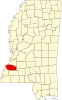 | |
| Unincorporated communities | ||
| Ghost towns | ||
Images to move up[edit]


