
Tollville, Arkansas
Tollville, Arkansas | |
|---|---|
 Tollville, Arkansas  Tollville, Arkansas | |
| Coordinates: 34°43′11″N 91°32′07″W / 34.71972°N 91.53528°W | |
| Country | United States |
| State | Arkansas |
| County | Prairie |
| Elevation | 220 ft (70 m) |
| Time zone | UTC-6 (Central (CST)) |
| • Summer (DST) | UTC-5 (CDT) |
| Area code | 870 |
| GNIS feature ID | 57211[1] |
Tollville is an unincorporated community east of Little Rock in Prairie County, Arkansas, United States.
History[edit]
The community was reportedly founded by the Toll family, who were English emigrants. Founding families also included the Claytons and the Foots. Lord Thomas Marsh Horsfall, a local Englishman and entrepreneur, owned much of this prairie ground in the late 1880s.[2] Many residents worshiped at an Episcopal Church (St. Peter's on the Prairie) that was erected in 1904.[3]
References[edit]
- ^ a b U.S. Geological Survey Geographic Names Information System: Tollville, Arkansas
- ^ Sickel, Marilyn Hambrick (February 14, 1995). "History of Prairie County". Ancestry.com. Retrieved August 14, 2009.
- ^ Protestant Episcopal Church (1905). Journal Proceedings of the 33rd Annual Council of the Diocese of Arkansas. Little Rock, Arkansas: Arkansas Democrat Company. p. 83. Retrieved August 14, 2009.
Municipalities and communities of Prairie County, Arkansas, United States | ||
|---|---|---|
| Cities | 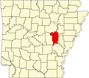 | |
| Towns | ||
| Unincorporated communities | ||
| Footnotes | ‡This populated place also has portions in an adjacent county of counties | |
This article about a location in Prairie County, Arkansas is a stub. You can help Wikipedia by expanding it. |