
The Vice President (mountain)
| The Vice President | |
|---|---|
_from_Isolated_col.jpg) Vice President & President (l-r) from Isolated col | |
| Highest point | |
| Elevation | 3,077 m (10,095 ft) |
| Prominence | 157 m (515 ft)above President Pass |
| Coordinates | 51°30′02″N 116°33′01″W / 51.50056°N 116.55028°W |
| Geography | |
| Location | British Columbia, Canada |
| District | Kootenay Land District |
| Parent range | Canadian Rockies |
| Topo map | NTS 82N10 Blaeberry River |
| Climbing | |
| First ascent | 1901 by James Outram, Christian Kaufmann and Joseph Pollinger |
| Easiest route | scramble |
The Vice President is a mountain on The President/Vice President Massif just north of Emerald Lake in Yoho National Park, near the Alpine Club of Canada's Stanley Mitchell hut. The Vice President was named Mount McNicoll in 1904 by Edward Whymper after David McNicoll, the VP of the Canadian Pacific Railway. In 1907, the mountain was renamed by the Alpine Club of Canada, after it was discovered that the name had already been used on a mountain near Rogers Pass.
Routes[edit]
There appears to be only one route up the Vice President—up the President glacier to the col, then up a snow slope to the ridge, then to the peak.
External links[edit]
Gallery[edit]
-
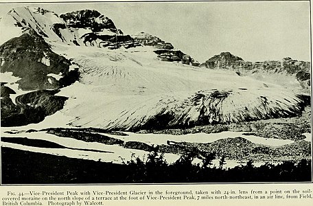 The Vice President and glacier (1910)
 -
 Left to right, The Vice President, President glacier and The President
_(14759415596).jpg)

This article about a location in the Interior of British Columbia, Canada is a stub. You can help Wikipedia by expanding it. |