
Terschuur
Terschuur | |
|---|---|
Village | |
 | |
 Terschuur Location in the Netherlands  Terschuur Terschuur (Netherlands) | |
| Coordinates: 52°09′48″N 5°31′03″E / 52.1634°N 5.5176°E | |
| Country | Netherlands |
| Province | Gelderland |
| Municipality | Barneveld |
| Area | |
| • Total | 13.43 km2 (5.19 sq mi) |
| Elevation | 6 m (20 ft) |
| Population (2021)[1] | |
| • Total | 1,505 |
| • Density | 110/km2 (290/sq mi) |
| Time zone | UTC+1 (CET) |
| • Summer (DST) | UTC+2 (CEST) |
| Postal code | 3784[1] |
| Dialing code | 0342 |
Terschuur is a village in the Dutch province of Gelderland. It is located in the municipality of Barneveld.
History[edit]
It was first mentioned around 1400 as "den teende ther schuren", and means "at the barn".[3] Terschuur used to part of Zwartebroek. The village developed on the road from Amsterdam to Amersfoort. There used to be a toll house at the village. In 1421, the toll house was burnt down by angry citizens.[4] The estate Terschuur which was built around 1830. The windmill Den Olden Florus is from 1881, but a predecessor used to be at the location before 1635.[5]
From 1888 until 1931 there was a railway stop at Terschuur. In 1930, it became a separate village.[4]
Notable people[edit]
- Johan Jansen (born 1989), professional footballer[6]
Gallery[edit]
-
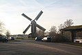 Windmill "Den Olden Florus"
 -
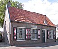
 Egg house
 -
 Farm in Terschuur
 -
 The former toll house


References[edit]
- ^ a b c "Kerncijfers wijken en buurten 2021". Central Bureau of Statistics. Retrieved 19 March 2022.
- ^ "Postcodetool for 3784KA". Actueel Hoogtebestand Nederland (in Dutch). Het Waterschapshuis. Retrieved 19 March 2022.
- ^ "Terschuur - (geografische naam)". Etymologiebank (in Dutch). Retrieved 19 March 2022.
- ^ a b "Terschuur". Plaatsengids (in Dutch). Retrieved 19 March 2022.
- ^ Ronald Stenvert & Sabine Broekhoven (2000). "Terschuur" (in Dutch). Zwolle: Waanders. p. 295. ISBN 90 400 9406 3. Retrieved 19 March 2022.
- ^ "Johan Jansen". World Football. Retrieved 19 March 2022.
This Gelderland location article is a stub. You can help Wikipedia by expanding it. |