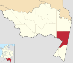
Tarapacá, Amazonas
Tarapacá, Amazonas | |
|---|---|
Municipality and town | |
 Location of the municipality and town of Tarapacá, Amazonas in the Amazonas Department of Colombia | |
| Coordinates: 2°52′44″S 69°44′38″W / 2.87889°S 69.74389°W | |
| Country | |
| Department | |
| Founded | 14 February 1909 |
| Area | |
| • Total | 1,443 km2 (557 sq mi) |
| Population (2015) | |
| • Total | 4,195 |
| Time zone | UTC-5 (Colombia Standard Time) |
| Climate | Af |
Tarapacá is a town and municipality in the Colombian Department of Amazonas. As of 2015, the population comprised 4,195 people.
The town is served by Tarapacá Airport.
History[edit]
Originally founded by Peruvian refugees from the War of the Pacific, it was awarded to Colombia after the Salomón-Lozano Treaty signing in July 1922.[1][2] These refugees would later resettle in the settlement of the same name in northern Peru.
Places with the same name[edit]
See also[edit]
References[edit]
- ^ Porras Barrenechea, Raúl. Historia de los límites del Perú (PDF). Librería Francesa Científica y Casa Editorial E. Rosay. p. 79-80. Archived from the original (PDF) on 6 November 2014.
- ^ Núñez Atencio, Lautaro y Maldonado Prieto, Carlos (2005). Reseña bibliográfica: El Dios Cautivo. Las Ligas Patrióticas en la chilenización compulsiva de Tarapacá (1910-1922), Sergio González Miranda, LOM Ediciones, Santiago, 2004. Vol. 37. Chungará (Arica), Universidad de Tarapacá. ISSN 0717-7356. [1].
{{cite book}}: CS1 maint: multiple names: authors list (link)

