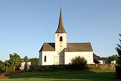
Steuerberg
Appearance
Steuerberg | |
|---|---|
 Church of Saints Peter and Paul | |
| Coordinates: 46°47′N 14°7′E / 46.783°N 14.117°E | |
| Country | Austria |
| State | Carinthia |
| District | Feldkirchen |
| Government | |
| • Mayor | Karl Petritz (ÖVP) |
| Area | |
• Total | 32.76 km2 (12.65 sq mi) |
| Elevation | 782 m (2,566 ft) |
| Population (2018-01-01)[2] | |
• Total | 1,662 |
| • Density | 51/km2 (130/sq mi) |
| Time zone | UTC+1 (CET) |
| • Summer (DST) | UTC+2 (CEST) |
| Postal code | 9560 |
| Website | www.steuerberg.at |
Steuerberg (Slovene: Šterska Gora) is a town in the district of Feldkirchen in the Austrian state of Carinthia.
Geography
[edit]Steuerberg lies in the Gurktal Alps between the Gurk valley and the Wimitz valley, about 10 km north of Feldkirchen.
Neighboring municipalities
[edit]| Albeck | Weitensfeld | |
| Gnesau | 
|
Frauenstein |
| Himmelberg | Feldkirchen | Sankt Urban |
References
[edit]- ^ "Dauersiedlungsraum der Gemeinden Politischen Bezirke und Bundesländer - Gebietsstand 1.1.2018". Statistics Austria. Retrieved 10 March 2019.
- ^ "Einwohnerzahl 1.1.2018 nach Gemeinden mit Status, Gebietsstand 1.1.2018". Statistics Austria. Retrieved 9 March 2019.
Wikimedia Commons has media related to Steuerberg.


