
St John the Evangelist, Knotty Ash
| St John the Evangelist's Church, Knotty Ash | |
|---|---|
 St John the Evangelist's Church, Knotty Ash | |
 | |
| 53°24′59″N 2°53′30″W / 53.41625°N 2.891717°W | |
| Location | Knotty Ash, Liverpool, Merseyside |
| Country | England |
| Denomination | Anglican |
| History | |
| Status | Parish church |
| Dedication | St John the Evangelist |
| Architecture | |
| Functional status | Active |
| Heritage designation | Grade II |
| Architect(s) | Williams and Edwards |
| Architectural type | Church |
| Style | Gothic |
| Groundbreaking | 1834 |
| Completed | 1836 |
| Administration | |
| Province | York |
| Diocese | Liverpool |
| Archdeaconry | Liverpool |
| Deanery | Huyton |
| Parish | Knotty Ash |
| Laity | |
| Music group(s) | Damascus Road |
St John the Evangelist, Knotty Ash, is a church in the Knotty Ash area of Liverpool, Merseyside, England. It is on Thomas Lane[1] and was built 1834–6.
The architects were Williams and Edwards[2] and it was built by Richard and Paul Barker[3] of Huyton in red ashlar sandstone.[4] There is a narrow west tower with recessed spire and thin polygonal buttresses. It has tall church sides with three light perpendicular windows and thin buttresses. The taller chancel with south chapel is an 1890 addition by Aldridge and Deacon. There is an excellent late 19th century Celtic cross in the churchyard, finely carved. The churchyard contains war graves of three soldiers, a Royal Navy sailor and a Royal Air Force officer of World War I and three soldiers and an airman of World War II.[5]
More detail about the history of St John's and its graveyard with war memorial graves in plots 10:C9 and 10:C10 and the grave of Norman Harrison, Second Engineer of the S.S. Titanic plot 5:C6, can also be found on the churches website..
Images[edit]
-
 Nave towards the chancel
 -
 West end and tower
 -
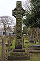 The Celtic cross. This is a Cenotaph for a local businessman and his wife, John & Elizabeth Bencke.


See also[edit]
References[edit]
- ^ "St. John the Evangelist Knotty Ash". Achurchnearyou.com. Retrieved 4 July 2012.
- ^ "St John the Evangelist, Knotty Ash:: OS grid SJ4091 :: Geograph Britain and Ireland - photograph every grid square!". Geograph.org.uk. 18 February 2006. Retrieved 4 July 2012.
- ^ "History". Stjohns-knottyash.org.uk. Retrieved 4 July 2012.
- ^ "North Liverpool: Knotty Ash, West Derby and Croxteth". Allertonoak.com. 30 November 2011. Retrieved 4 July 2012.
- ^ [1] CWGC Cemetery Report. Breakdown obtained from casualty record.
- The Buildings of England; Lancashire: Liverpool and the South-West; by Richard Pollard and Nikolaus Pevsner ISBN 0 300 109105
This article about a church or other Christian place of worship in England is a stub. You can help Wikipedia by expanding it. |