
Soignes Forest Railway
| Soignes Forest Railway | |||||||||||||||||||||||||||||||||||||||||||||||||||||||||||||||||||||||||
|---|---|---|---|---|---|---|---|---|---|---|---|---|---|---|---|---|---|---|---|---|---|---|---|---|---|---|---|---|---|---|---|---|---|---|---|---|---|---|---|---|---|---|---|---|---|---|---|---|---|---|---|---|---|---|---|---|---|---|---|---|---|---|---|---|---|---|---|---|---|---|---|---|---|
| Overview | |||||||||||||||||||||||||||||||||||||||||||||||||||||||||||||||||||||||||
| Native name | Chemin de fer de la forêt de Soignes | ||||||||||||||||||||||||||||||||||||||||||||||||||||||||||||||||||||||||
| Status | Closed and disappeared | ||||||||||||||||||||||||||||||||||||||||||||||||||||||||||||||||||||||||
| Service | |||||||||||||||||||||||||||||||||||||||||||||||||||||||||||||||||||||||||
| Type | Decauville | ||||||||||||||||||||||||||||||||||||||||||||||||||||||||||||||||||||||||
| History | |||||||||||||||||||||||||||||||||||||||||||||||||||||||||||||||||||||||||
| Opened | 1902 | ||||||||||||||||||||||||||||||||||||||||||||||||||||||||||||||||||||||||
| Closed | 1918 | ||||||||||||||||||||||||||||||||||||||||||||||||||||||||||||||||||||||||
| Technical | |||||||||||||||||||||||||||||||||||||||||||||||||||||||||||||||||||||||||
| Line length | 2.5 km (1.6 mi) | ||||||||||||||||||||||||||||||||||||||||||||||||||||||||||||||||||||||||
| Number of tracks | 1 | ||||||||||||||||||||||||||||||||||||||||||||||||||||||||||||||||||||||||
| Track gauge | 600 mm (1 ft 11+5⁄8 in) | ||||||||||||||||||||||||||||||||||||||||||||||||||||||||||||||||||||||||
| Electrification | No | ||||||||||||||||||||||||||||||||||||||||||||||||||||||||||||||||||||||||
| |||||||||||||||||||||||||||||||||||||||||||||||||||||||||||||||||||||||||
The Soignes Forest Railway was a Belgian type Decauville railway, which has disappeared since its closing
History[edit]
Put into service in 1902, this railway linked the Petite Espinette, a place called the municipality of Uccle (at the limit of Rhode-Saint-Genèse) then served by the old line to Waterloo of the Brussels tram, at Boitsfort, on the railway line Brussels – Namur – Luxembourg. Established in the Forêt de Soignes, the length of the line is 2.5 kilometres (1.6 mi).
After the First World War, it was abandoned for reasons of unprofitability. This railway line transported the gravelling materials for the forest paths, and was also used to transport wood.[1]
Location[edit]
Starting from the beginning of the drève Saint-Hubert, the railway crossed the drève de Lorraine to then follow a large part of the drève des Deux Montagnes.
Gallery[edit]
The Railway[edit]
-
![The railway ~ before 1920 (Chemin des Deux Montagnes).[2]](//upload.wikimedia.org/wikipedia/commons/thumb/1/10/Neolothische_site_%27Bosvoorde-Vijvers%27_aan_de_Twee_Bergenlaan_in_Watermaal-Bosvoorde._Gedeeltelijk_zicht_op_de_grachten_en_aarden_wallen_van_het_Decauville-veldspoor_in_het_Zoni%C3%ABnwoud.jpg/247px-thumbnail.jpg) The railway ~ before 1920 (Chemin des Deux Montagnes).[2]
The railway ~ before 1920 (Chemin des Deux Montagnes).[2] -
 Decauville wagon or open wagon used at the time.
![The railway ~ before 1920 (Chemin des Deux Montagnes).[2]](./wiki.php?slug=File:Neolothische_site_%27Bosvoorde-Vijvers%27_aan_de_Twee_Bergenlaan_in_Watermaal-Bosvoorde._Gedeeltelijk_zicht_op_de_grachten_en_aarden_wallen_van_het_Decauville-veldspoor_in_het_Zoni%C3%ABnwoud.jpg)

The shed[edit]
Built in 1902 (just like the line), the shed[3] was renovated in 2003. Having served as a shed for the rolling stock, it is the only remaining vestige of the old railway. In the 2010s, this building served as a storage and shelter for foresters.
- The shed in 2017
-
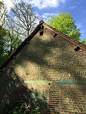 Traces of the three old rolling stock access gates.
 -
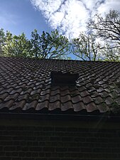 Entrance for bats, fitted in the roof.
 -
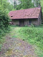 Shed in the Sonian Forest


See also[edit]
References[edit]
- ^ According to the IBGE(fr).
- ^ (in Dutch) Source: [http:/ /app.bruxellesenvironnement.be/multimedia/plan-gestion-foret-soignes/Boek_III_20190404_Reserves_NL.pdf bruxellesenvironnement.be]
- ^ The hangar is located at the coordinates: 50°46′38″N 4°23′32″E / 50.777297°N 4.392238°E (taken from Google Maps).
Literature[edit]
- Stéphane Vanwijnsberghe und Jean-Christophe Prignon: Beheerplan voor het Brussels gedeelte van het Zoniënwoud. Boek III. Beheerplannen voor de archeologische sites, natuurreservaten en bosreservaten.
- Stéphane Vanwijnsberghe und Jean-Christophe Prignon: Plan de gestion de la Forêt de Soignes bruxelloise. Livre III. Plans de gestion des réserves archéologiques, naturelles et forestières.
- Bart Vanmontfort, Els Meirsman und Roger Langohr: Archeologische evaluatie van de neolothische site (Bosvoorde-Vijvers) Twee Bergenlaan in Watermaal-Bosvoorde.