
Santal Parganas district
| Sonthal Parganas district | |||||||||||
|---|---|---|---|---|---|---|---|---|---|---|---|
| Former district of British and independent India | |||||||||||
| 1855–1983 | |||||||||||
.jpg) Santal Parganas district and its railway line as depicted in the 1872 map | |||||||||||
| Capital | Dumka | ||||||||||
| Area | |||||||||||
• 1855 | 14,167.23 km2 (5,470.00 sq mi) | ||||||||||
| Population | |||||||||||
• 1901[1] | 1,809,737 | ||||||||||
| Government | |||||||||||
| Commissioner | |||||||||||
• 1855 | George Yule | ||||||||||
| History | |||||||||||
• Established | 1855 | ||||||||||
• Bifurcation | 1983 | ||||||||||
| |||||||||||
The Sonthal Parganas district, also known as Santal Parganas district,[2][3][1] was created as a separate administrative division following the Santal uprising of 1855-56,[4] which exposed the oppression faced by the Santals and prompted British reforms. The establishment of the district was formalized under the Sonthal Parganas Act, Act 37 of 1855.[5][6][7]
History
[edit]Background
[edit]The Santals originally inhabited the region from Hazaribagh to Medinipur, farming along the Subarnarekha River. Following the 1770 Bengal famine, the demand for agricultural land prompted their migration. In 1832, the British designated Damin-i-koh for settlement, initially offering it to the Paharia tribe, who refused. The Santals, migrating from Dhalbhum, Manbhum, Hazaribagh, and Midnapore, rapidly increased in population, from 3,000 in 1838 to 82,790 in 1851.[8]
James Pontet was assigned in 1837 to manage Damin-i-koh for revenue generation, but tensions grew as the Santals resisted outsiders, including exploitative moneylenders and landlords. The construction of a railway further disrupted their livelihood. By the 1850s, resentment grew due to the oppressive revenue system and British-backed landlords.[9][10][11][12]
In 1855, the Santal Rebellion erupted, with the rebels capturing Barhait and achieving an early victory at Pirpainti. British officials George Francis Brown and Major F. W. Burroughs responded by declaring martial law. Brown was later criticized for procedural errors, while Burroughs led the British forces. The British then appointed Alfred Clarke Bidwell to suppress the rebellion. Despite fierce resistance, the Santals were defeated, with thousands killed. Bidwell blamed Pontet for neglecting the settlers, and the rebellion exposed the exploitation of the Santals, leading to British reforms.[13][14][15]
Established
[edit]
The Sonthal Parganas Act, Act 37 of 1855, led to the creation of Santal Parganas as a non-regulation district under Bhagalpur’s jurisdiction. The region was administered by a Deputy Commissioner stationed in Dumka, who was assisted by other officials. This administrative structure was modeled after the South-West Frontier Agency of Chota Nagpur. Covering 5,470 square miles, it was bordered by Bhagalpur, Purnea, Malda, Murshidabad, Birbhum, Bardwan, Manbhum, Hazaribagh, and Monghyr. The district aimed to address Santal grievances while reinforcing British control.[5][6][7][1]
Before the creation of Santal Parganas district, its northern half was part of Bhagalpur district, while the southern and western regions were under Birbhum district.[16] The British referred to this region as Jungleterry (Jungle Terai) after assuming Diwani in 1765.[17]
Bifurcation
[edit]
In 1983, after approximately 128 years, Santal Parganas district was reorganized into four separate districts under the Santhal Pargana division, with the subdivisions of Dumka, Deoghar, Sahibganj, and Godda officially designated as independent districts for administrative purposes.[18] Further, in 2001, Pakur subdivision of Sahibganj district and Jamtara subdivision of Dumka district were carved out as separate districts.[17]
Administration
[edit]A separate Santal Parganas district was established in 1855, with George Yule appointed as the first administrator. Yule also held the position of Commissioner at Bhagalpur, with Ashley Eden serving as his deputy. Their administration was responsible for overseeing governance and implementing policies designed to manage the region's affairs in accordance with British colonial interests.[4][19]
Demographics
[edit]| Year | Pop. | ±% |
|---|---|---|
| 1872 | 1,882,973 | — |
| 1881 | 1,809,737 | −3.9% |
| 1891 | 1,753,775 | −3.1% |
| 1901 | 1,567,966 | −10.6% |
| 1911 | 1,259,185 | −19.7% |
| 1921 | 1,794,908 | +42.5% |
| 1931 | 2,050,258 | +14.2% |
| 1941 | 2,234,497 | +9.0% |
| 1951 | 2,322,092 | +3.9% |
| 1961 | 2,675,203 | +15.2% |
| 1971 | 3,186,908 | +19.1% |
| 1981 | 3,717,528 | +16.6% |
| Notes: The actual population of the district varies slightly across different sources due to adjustments in area. Source: Census of India[20][21][22][23]: 236 | ||
Religion
[edit]Language
[edit]Communities
[edit]According to the 1901 census, as the name implies, the Santhal Pargana district was overwhelmingly inhabited by Santhals, who constituted 36.6% of the total population. They were followed by Bhuiya (7.0%), Ahir and Goala (6.0%), Sheikh (4.3%), Jolha (3.5%), Malar (2.6%), Dom (2.5%), Rajput (2.4%), Teli and Kalu (2.4%), Brahmin (1.9%), Chamar and Muchi (1.9%), Kalwar and Sunri (1.8%), Musahar (1.6%), Kumhar (1.5%), Mal Paharia (1.4%), Kamar and Lohar (1.3%), Bauri (1.3%), weaving castes (i.e., Tanti) (1.2%), Chain (1.1%), Kahar and Behara (1.0%), and Hajjam and Napit (1.0%). Meanwhile, Kurmi, Dhanuk, Koiri, Halwa, Mayara, Kandu, Mahli, Dosadh, Rajwar, Hari, Mehtar, and others accounted for less than 15,000 people (i.e., 1% of the population).[26] As of the 1981 census, Scheduled Castes and Scheduled Tribes comprised 45.19% of the district's population, with 8.39% belonging to Scheduled Castes and 36.8% to Scheduled Tribes.[27]
Gallery
[edit]-
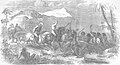 A residual skirmish between British railway engineers and Santal people
 -
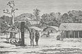 A Santhal hamlet in the Rajmahal Hills, illustrating houses, elephant deities, and sacrificial head trophies, Louis Rousselet (c. 1864 – c. 1868 observation; pub. 1875).
 -
 Railway passing through the Santhal Parganas, 1856.
 -
 British forces escorting captured Santhals to prison.


References
[edit]- ^ a b c . Encyclopædia Britannica. Vol. 24 (11th ed.). 1911. p. 188.
- ^ OʼMalley & McPherson (1910)
- ^ Prasad, S.D (1965). District Census Handbook, Santal Parganas, 12, Bihar - Census 1961 (PDF). Director of Census Operations, Bihar.
- ^ a b Lalita Prasad Vidyarthi (1981). Tribal Development and Its Administration. Concept Publishing Company. pp. 68–. GGKEY:AH844SJ8Q3E.
- ^ a b Wary, Jaysagar; Brahma, Bijit (January 2024). "Journey to New Land: Quest for Santal Settlement in Goalpara District of Assam During Colonial Period". History and Sociology of South Asia. 18 (1): 69–85. doi:10.1177/22308075231201908.
- ^ a b Chopra, P.N.; Xaviar, Arakal, eds. (1985). India's Struggle for Freedom: Role of Associated Movements. Vol. 3. Agam Prakashan. OCLC 13879742. Alt URL
- ^ a b "SONTHAL PARGANAS ACT 1855". www.commonlii.org.
- ^ "Interrogating Temporal and Spatial Demarcations in History Writing | Economic and Political Weekly". www.epw.in: 58–64. 20 December 2024.
- ^ Somers, George E. (December 1985). The Dynamics of Santal Traditions in a Peasant Society. Abhinav Publications. p. 252. ISBN 978-0-8364-1516-2.
- ^ Gott, Richard (7 November 2011). Britain's Empire: Resistance, Repression and Revolt. Verso Books. p. 435. ISBN 978-1-84467-738-2.
- ^ "Anti-Colonial Resistance by the Subaltern: The Santhal Rebellion, 1855-1856". amritmahotsav.nic.in.
- ^ "'Santhal Hul' rebellion in Jharkhand was 1st war of Independence against British rule". www.daijiworld.com. Retrieved 2024-07-03.
- ^ Gott, Richard (7 November 2011). Britain's Empire: Resistance, Repression and Revolt. Verso Books. pp. 436–439. ISBN 978-1-84467-738-2.
- ^ Chaudhuri, B. B. (2008). Peasant History of Late Pre-colonial and Colonial India. Pearson Education India. p. 722. ISBN 978-81-317-1688-5.
- ^ Bradley-Birt, F. B. (1990). History and Ethnology of an Indian Upland. Mittal Publications. p. 207.
- ^ Jha, Amar Nath (2009). "Locating the Ancient History of Santal Parganas". Proceedings of the Indian History Congress. 70: 185–196. ISSN 2249-1937.
- ^ a b "Census of India 2011 - Jharkhand - Series 21 - Part XII B - District Census Handbook, Jamtara" (PDF). censusindia.gov.in.
- ^ "Santal Pargana was formed as a district during the British rule ब्रिटिश शासनकाल में जिला था संताल परगना, 1983 में 4 भागों में बंटा; दिलचस्प है कहानी, Jharkhand Hindi News - Hindustan". livehindustan.com.
- ^ S. P. Sinha (1 January 1993). Conflict and Tension in Tribal Society. Concept Publishing Company. pp. 42–3. ISBN 978-81-7022-493-8.
- ^ Census of India, 1911 (PDF). Vol. V. Bihar and Orissa. Part- III.
{{cite book}}: CS1 maint: others (link) - ^ Census of India, 1931 (PDF). Vol. VII. Bihar and Orissa. Part- III Tables.
{{cite book}}: CS1 maint: others (link) - ^ Roy Choudhary (1965), p. 143
- ^ Lal, B.B. (1987). General Population Tables, Part II-A, Series-4, Bihar - Census 1981 (PDF). Director of Census Operations, Bihar.
- ^ Lal, B. B. (1986). Household Population by Religion of Head of Household, Paper 1, Series-4, Bihar - Census 1981 (PDF). Director of Census Operations, Bihar.
- ^ Lal, B. B. (1987). Households and Household Population by Language Mainly Spoken in the Household, Paper 1 of 1987, Series-4, Bihar - Census 1981 (PDF). Director of Census Operations, Bihar.
- ^ OʼMalley & McPherson (1910), p. 70
- ^ Primary Census Abstract, Part II-B, Series-4, Bihar - Census 1981 (PDF). Director of Census Operations, Bihar. 1985. p. 8.
Bibliography
[edit]- OʼMalley, L.S.S.; McPherson, R.H. (1910). Bengal District Gazetteers: Santal Parganas. Calcutta, Bengal Secretariat Book Depot.
- Roy Choudhary, P.C. (1965). Bihar District Gazetteers: Santhal Parganas. Patna, Superintendent Secretariat Press.
- Kochuchira, John (2000). Political History of Santal Parganas from 1765 to 1872. Inter-India Publications. ISBN 978-81-210-0397-1. OCLC 46929506.