
Sand Brook, New Jersey
Sand Brook, New Jersey | |
|---|---|
 Former Sand Brook General Store | |
 Sand Brook Location of Sand Brook in Hunterdon County Inset: Location of county within the state of New Jersey  Sand Brook Sand Brook (New Jersey)  Sand Brook Sand Brook (the United States) | |
| Coordinates: 40°28′09″N 74°55′01″W / 40.46917°N 74.91694°W | |
| Country | |
| State | |
| County | Hunterdon |
| Township | Delaware |
| Elevation | 318 ft (97 m) |
| GNIS feature ID | 880245[1] |
Sand Brook is an unincorporated community located along County Route 523, Sand Brook-Headquarters & Britton Roads in Delaware Township in Hunterdon County, in the U.S. state of New Jersey.[2]
Historic district[edit]
Sand Brook Historic District | |
| Area | 27 acres (11 ha) |
|---|---|
| Architectural style | Greek Revival, Late Victorian |
| NRHP reference No. | 13000497[3] |
| NJRHP No. | 4843[4] |
| Significant dates | |
| Added to NRHP | July 17, 2013 |
| Designated NJRHP | February 21, 2013 |
The Sand Brook Historic District is a 27-acre (11 ha) historic district encompassing the community. It was added to the National Register of Historic Places on July 17, 2013, for its significance in architecture and community development.[3] The district includes 16 contributing buildings, six contributing structures, and two contributing sites. It includes Greek Revival and Late Victorian architecture.[5]
The former Sand Brook General Store was built around 1902 by Samuel F. Fauss. It is a two-story frame building featuring Queen Anne architecture.[5] The Sand Brook German Baptist Church was built around 1850 by a group from the Amwell Church of the Brethren. It is a one-story stuccoed-stone building with Greek Revival influences. The congregation was locally known as the "Moorites", after elder John P. Moore and his family.[5][6] The small stone-walled cemetery located behind the church also contributes to the district.[5]
-
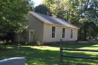 German Baptist Church
 -
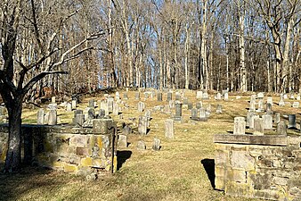 Cemetery


References[edit]
- ^ a b "Sand Brook". Geographic Names Information System. United States Geological Survey, United States Department of the Interior.
- ^ Locality Search, State of New Jersey. Accessed January 31, 2015.
- ^ a b "National Register Information System – (#13000497)". National Register of Historic Places. National Park Service. November 2, 2013.
- ^ "New Jersey and National Registers of Historic Places – Hunterdon County" (PDF). New Jersey Department of Environmental Protection – Historic Preservation Office. September 11, 2023. p. 5.
- ^ a b c d Bertland, Dennis; Armstrong, Janice (June 2012). "National Register of Historic Places Inventory/Nomination: Sand Brook Historic District". National Park Service. With accompanying 15 photos.
- ^ Snell, James P. (1881). "German Baptist Church of Sand Brook". History of Hunterdon and Somerset Counties, New Jersey. Everts & Peck. p. 381.
External links[edit]
 Media related to Sand Brook, New Jersey at Wikimedia Commons
Municipalities and communities of Hunterdon County, New Jersey, United States | ||
|---|---|---|
| City |  | |
| Boroughs | ||
| Town | ||
| Townships | ||
| CDPs | ||
| Other communities |
| |
| Footnotes | ‡This populated place also has portions in an adjacent county or counties | |
| Topics |  | |
|---|---|---|
| Lists by county | ||
| Other lists | ||