
Saint-Ubalde
Saint-Ubalde | |
|---|---|
 | |
.svg) Coat of arms | |
 Location within Portneuf RCM | |
 Saint-Ubalde Location in central Quebec | |
| Coordinates: 46°45′N 72°16′W / 46.750°N 72.267°W[1] | |
| Country | |
| Province | |
| Region | Capitale-Nationale |
| RCM | Portneuf |
| Settled | 1860 |
| Constituted | March 3, 1973 |
| Government | |
| • Mayor | Pierre Saint-Germain |
| • Federal riding | Portneuf—Jacques-Cartier |
| • Prov. riding | Portneuf |
| Area | |
| • Total | 146.40 km2 (56.53 sq mi) |
| • Land | 140.21 km2 (54.14 sq mi) |
| Population (2011)[3] | |
| • Total | 1,403 |
| • Density | 10.0/km2 (26/sq mi) |
| • Pop 2006-2011 | |
| • Dwellings | 1,015 |
| Time zone | UTC−5 (EST) |
| • Summer (DST) | UTC−4 (EDT) |
| Postal code(s) | |
| Area code(s) | 418 and 581 |
| Highways | |
| Website | saintubalde |
Saint-Ubalde is a rural municipality in Portneuf County in the Canadian province of Quebec.
Geographically its territory is marked by an agricultural and populated area in the south-west, and an undeveloped hilly area in the north-east.
Numerous watercourses and lakes (Blanc, Sainte-Anne, Ricard, Thom) crisscross and dot is entire territory.
The inhabited section is located in the southeast. Saint-Ubalde is centred on potato cultivation and outdoor recreation (canoeing, water skiing, fishing).[1]'.[4]
History[edit]
Saint-Ubald (originally without an "e") was founded by people from Neuville in 1860, and the Saint-Ubald Mission was established that same year. It was named after Ubald Gingras (1824-1874), first sacristan of the place but originally from Pointe-aux-Trembles (Portneuf), and who was brother-in-law of Charles-François Baillargeon, archbishop of Quebec. The mission became a parish in 1866 by separating from Saint-Casimir. In 1873, the civil parish was formed and incorporated as a parish municipality. A year later, its post office opened.[1]
In 1920, the village centre separated from the parish municipality to form the Village Municipality of Saint-Ubalde. But in 1973, the parish and village municipalities merged again to form the new Municipality of Saint-Ubalde.[1]
Demographics[edit]
Population trend:[5]
- Population in 2011: 1403 (2006 to 2011 population change: -3.8%)
- Population in 2006: 1458
- Population in 2001: 1460
- Population in 1996: 1540
- Population in 1991: 1552
Private dwellings occupied by usual residents: 646 (total dwellings: 1015)
Mother tongue:
- English as first language: 0%
- French as first language: 99.3%
- English and French as first language: 0%
- Other as first language: 0.7%
Photos[edit]
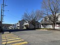
- St Paul-Street
-
 St-Paul & Commercial Street sign
 -
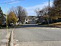 Heart of the municipality
 -
 Typical street of rural village


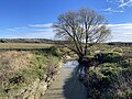
- Some watercourses in St-Ubalde
-
![Rivière Blanche (Saint-Casimir) bridge sign P-17644,[6] reinforced concrete gantry structure, rang Saint-Georges](//upload.wikimedia.org/wikipedia/commons/thumb/6/60/Saint_Ubalde_001.jpg/120px-Saint_Ubalde_001.jpg) Rivière Blanche (Saint-Casimir) bridge sign P-17644,[6] reinforced concrete gantry structure, rang Saint-Georges
Rivière Blanche (Saint-Casimir) bridge sign P-17644,[6] reinforced concrete gantry structure, rang Saint-Georges -
 Rivière Blanche (Saint-Casimir) from P-17644, rang Saint-Georges
 -
 Rivière Blanche (Saint-Casimir) from P-17644, rang Saint-Georges
 -
![Rivière Charest, from Steel and Wood Bridge P-18620,[6] Bureau Road](//upload.wikimedia.org/wikipedia/commons/thumb/9/98/Saint_Ubalde_015.jpg/120px-Saint_Ubalde_015.jpg) Rivière Charest, from Steel and Wood Bridge P-18620,[6] Bureau Road
Rivière Charest, from Steel and Wood Bridge P-18620,[6] Bureau Road -
 Rivière Charest, from Steel and Wood Bridge P-18620, Bureau Road
 -
![Weller River (Stream), steel and wood bridge P-19613,[6] rang Saint-Joseph](//upload.wikimedia.org/wikipedia/commons/thumb/0/02/Saint_Ubalde_030.jpg/120px-Saint_Ubalde_030.jpg) Weller River (Stream), steel and wood bridge P-19613,[6] rang Saint-Joseph
Weller River (Stream), steel and wood bridge P-19613,[6] rang Saint-Joseph
![Rivière Blanche (Saint-Casimir) bridge sign P-17644,[6] reinforced concrete gantry structure, rang Saint-Georges](./wiki.php?slug=File:Saint_Ubalde_001.jpg)


![Rivière Charest, from Steel and Wood Bridge P-18620,[6] Bureau Road](./wiki.php?slug=File:Saint_Ubalde_015.jpg)

![Weller River (Stream), steel and wood bridge P-19613,[6] rang Saint-Joseph](./wiki.php?slug=File:Saint_Ubalde_030.jpg)
See also[edit]
References[edit]
- ^ a b c d "Saint-Ubalde (municipalité)" (in French). Commission de toponymie du Québec. Retrieved 2010-03-29.
- ^ a b Ministère des Affaires municipales, des Régions et de l'Occupation du territoire - Répertoire des municipalités: Saint-Ubalde Archived 2015-12-09 at the Wayback Machine
- ^ a b Statistics Canada 2011 Census - Saint-Ubalde census profile
- ^ Stéfanos (2012-07-30). "Hydrological and multi-resource portrait of the Sainte-Anne River watershed" (PDF) (in French). CAPSA. pp. 27/137. Retrieved 2023-11-01.
- ^ Statistics Canada: 1996, 2001, 2006, 2011 census
- ^ a b c "Inventory and Inspection of Structures". Ministère des Transports et de la Mobilité durable (in French). Government of Quebec. 2023-11-01. Retrieved 2023-10-31.
External links[edit]
![]() Media related to Saint-Ubalde at Wikimedia Commons
Media related to Saint-Ubalde at Wikimedia Commons
Adjacent Municipal Subdivisions | |
|---|---|
| Cities & towns | |
|---|---|
| Municipalities | |
| Parishes | |
| Unorganized territories | |
| |
| International | |
|---|---|
| National | |