Prestolee Aqueduct
Prestolee Aqueduct | |
|---|---|
 Panorama of Prestolee Aqueduct | |
| Coordinates | 53°33′09″N 2°22′35″W / 53.5525°N 2.3764°W |
| OS grid reference | SD751062 |
| Carries | Manchester, Bolton and Bury Canal |
| Crosses | River Irwell |
| Locale | Prestolee, Greater Manchester |
| Heritage status | Grade II |
| Characteristics | |
| Trough construction | Stone |
| Pier construction | Stone |
| Total length | 185 feet (56.4 m) |
| Width | 16 feet 6 inches (5.03 m) |
| Traversable? | Yes |
| Towpaths | SW Side |
| No. of spans | Four |
| History | |
| Construction end | 1793 |
| Location | |
 | |
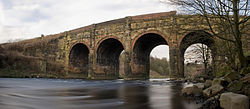
Prestolee Aqueduct is a stone-built aqueduct in Prestolee, Kearsley in the Metropolitan Borough of Bolton, Greater Manchester, England. The four-arch structure was constructed in 1793 to carry the Manchester, Bolton and Bury Canal across the River Irwell. It is now preserved as a Grade II listed building.[1]
The aqueduct is one of two remaining major structures on the canal, the other being the Clifton Aqueduct. A third major aqueduct, Damside Aqueduct, was demolished in the 1950s.
As of 2007, the aqueduct still carried water, although it was not navigable as adjoining sections of the canal are in need of restoration.

See also[edit]
References[edit]
- ^ Historic England. "Prestolee Aqueduct (1162420)". National Heritage List for England. Retrieved 27 June 2008.


