Portal:Volcanoes/Selected article
| This Wikipedia page has been superseded by Portal:Volcanoes and is retained primarily for historical reference. |
| Note: Article entries are now being transcluded directly on the main portal page. However, this page should be retained for historical reference. |
Instructions
The layout design for these subpages is at Portal:Volcanoes/Selected article/Layout, and is as follows:
{{Portal:Volcanoes/Selected article/Layout
  |image= article image
  |size= size of the image
  |caption= rollover text
  |text= a summary of the article
  |link= link to the article
}}
Feel free to add Volcano related articles Featured articles to the above list. New selected articles should go to the next available subpage. After you create the page, be sure to update the "max=" parameter for this section's area on the main portal page.
Selected articles
Selected article 1
Portal:Volcanoes/Selected article/1
The 1980 eruption of Mount St. Helens, a volcano located in Washington state, in the United States, was a major volcanic eruption. The eruption was the most significant to occur in the contiguous 48 U.S. states (VEI = 5, 0.3 cu mi, 1.2 km3 of material erupted), in terms of power and volume of material released, since the 1915 eruption of California's Lassen Peak. The eruption was preceded by a two-month series of earthquakes and steam-venting episodes, caused by an injection of magma at shallow depth below the mountain that created a huge bulge and a fracture system on Mount St. Helens' north slope. An earthquake at 8:32 a.m. on May 18, 1980, caused the entire weakened north face to slide away, suddenly exposing the partly molten, gas- and steam-rich rock in the volcano to lower pressure. The rock responded by exploding into a very hot mix of pulverized lava and older rock that sped toward Spirit Lake so fast that it quickly passed the avalanching north face. A volcanic ash column rose high into the atmosphere and deposited ash in 11 U.S. states. At the same time, snow, ice, and several entire glaciers on the mountain melted, forming a series of large lahars (volcanic mudslides) that reached as far as the Columbia River, nearly fifty miles (eighty kilometers) to the south. Less severe outbursts continued into the next day only to be followed by other large but not as destructive eruptions later in 1980.
Selected article 2
Portal:Volcanoes/Selected article/2
Amchitka is a volcanic, tectonically unstable island in the Rat Islands group of the Aleutian Islands in southwest Alaska. It is about 68 kilometers (42 mi) long, and varies from 3 to 6 km (2–3.75 mi) in width.It has a maritime climate, with many storms, and mostly overcast skies. The island was populated for more than 2,500 years by the Aleut people, but has had no permanent population since 1832. It was included in the Alaska Purchase of 1867, and has since been part of the United States. During World War II, it was used as an airfield by US forces in the Battle of the Aleutian Islands. Amchitka was selected by the United States Atomic Energy Commission to be the site for underground detonations of nuclear weapons. Three such tests were carried out: Long Shot, an 80 kiloton blast in 1965; Milrow, a 1 megaton blast in 1969; and Cannikin in 1971 — at "under 5 megatons", the largest underground test ever conducted by the United States. The tests were highly controversial, with environmental groups fearing that the Cannikin explosion, in particular, would cause severe earthquakes and tsunamis. Amchitka is no longer used for nuclear testing, although it is monitored for the leakage of radioactive materials. Amchitka has a maritime climate, often foggy and windswept, with cloud cover 98 percent of the time.
Selected article 3
Portal:Volcanoes/Selected article/3
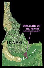
Craters of the Moon National Monument and Preserve is a national monument and national preserve located in the Snake River Plain in central Idaho near Arco, Idaho. The features in this protected area are volcanic and represent one of the best preserved flood basalt areas in the continental United States. The Monument was established on May 2, 1924. In November 2000, a Presidential proclamation greatly expanded the Monument area. The National Park Service portions of the expanded Monument were designated as Craters of the Moon National Preserve in August 2002. It lies in parts of Blaine, Butte, Lincoln, Minidoka, and Power counties. The area is managed cooperatively by the National Park Service and the Bureau of Land Management (BLM). The Monument and Preserve encompass three major lava fields and about 400 mi² (1,000 km²) of sagebrush steppe grasslands to cover a total area of 1117 mi² (2,892 km²). All three lava fields lie along the Great Rift of Idaho, with some of the best examples of open rift cracks in the world, including the deepest known on Earth) at 800 feet (240 m). There are excellent examples of almost every variety of basaltic lava as well as tree molds (cavities left by lava-incinerated trees), lava tubes (a type of cave), and many other volcanic features.
Selected article 4
Portal:Volcanoes/Selected article/4
Lōʻihi Seamount is an active undersea volcano located around 35 km (22 mi) off the southeast coast of the island of Hawaiʻi. It lies on the flank of Mauna Loa, the largest shield volcano on Earth. Lōʻihi Seamount is the newest volcano in the Hawaiian-Emperor seamount chain, a string of volcanoes that stretches over 5,800 km (3,600 mi) northwest of Lōʻihi and the island of Hawaiʻi. Unlike most active volcanoes in the Pacific ocean that make up the active plate margins on the Pacific Ring of Fire, Lōʻihi and the other volcanoes of the Hawaiian-Emperor seamount chain are hotspot volcanoes and formed well away from the nearest plate boundary. Volcanoes in the Hawaiian Islands arise from the Hawaiʻi hotspot, and as the youngest volcano in the chain, Lōʻihi is the only Hawaiian volcano in the deep submarine preshield stage of development. Lōʻihi began forming around 400,000 years ago and is expected to begin emerging above sea level about 10,000–100,000 years from now. At its summit, Lōʻihi Seamount stands more than 3,000 m (10,000 ft) above the seafloor, making it taller than Mount St. Helens was before its catastrophic 1980 eruption. A diverse microbial community resides around Lōʻihi's many hydrothermal vents.
Selected article 5
Portal:Volcanoes/Selected article/5
Enceladus is the sixth-largest moon of Saturn. It was discovered in 1789 by William Herschel. Until the two Voyager spacecraft passed near it in the early 1980s, very little was known about this small moon besides the identification of water ice on its surface. The Voyagers showed that Enceladus is only 500 km in diameter and reflects almost 100% of the sunlight that strikes it. Voyager 1 found that Enceladus orbited in the densest part of Saturn's diffuse E ring, indicating a possible association between the two, while Voyager 2 revealed that despite the moon's small size, it had a wide range of terrains ranging from old, heavily cratered surfaces to young, tectonically deformed terrain, with some regions with surface ages as young as 100 million years old. The Cassini spacecraft of the mid- to late 2000s acquired additional data on Enceladus, answering a number of the mysteries opened by the Voyager spacecraft and starting a few new ones. Cassini performed several close flybys of Enceladus in 2005, revealing the moon's surface and environment in greater detail. In particular, the probe discovered a water-rich plume venting from the moon's south polar region. This discovery, along with the presence of escaping internal heat and very few (if any) impact craters in the south polar region, shows that Enceladus is geologically active today. Moons in the extensive satellite systems of gas giants often become trapped in orbital resonances that lead to forced libration or orbital eccentricity; proximity to the planet can then lead to tidal heating of the satellite's interior, offering a possible explanation for the activity.
Selected article 6
Portal:Volcanoes/Selected article/6
The geology of the Lassen volcanic area presents a record of sedimentation and volcanic activity in the area in and around Lassen Volcanic National Park in Northern California, U.S.. The park is located in the southernmost part of the Cascade Mountain Range in the Pacific Northwest region of the United States. Oceanic tectonic plates have plunged below the North American Plate in this part of North America for hundreds of millions of years. Heat from these subducting plates have fed scores of volcanoes in California, Oregon, Washington and British Columbia over at least the past 30 million years (see Geology of the Pacific Northwest) and is also responsible for activities in the Lassen volcanic area. Between 3 and 4 million years ago, volcanic-derived mud flows called lahars streamed down several major mountains that included nearby but now extinct Mount Yana and Mount Maidu to become the Tuscan Formation. Basaltic and later andesitic to dacitic flows of lava covered increasingly larger areas of this formation to eventually form the lava plateau that the park sits on. About 600,000 years ago, Mount Tehama started to rise as a stratovolcano in the southwestern corner of the park, eventually reaching an estimated 11,000 feet (3,350 m) in height. Following a series of eruptions approximately 350,000 years ago, its cone collapsed into itself to form a two-mile (3 km) wide caldera.
Selected article 7
Portal:Volcanoes/Selected article/7
Io is the innermost of the four Galilean moons of Jupiter and, with a diameter of 3,642 kilometers, the fourth-largest moon in the Solar System. It was named after Io, a priestess of Hera that became one of the lovers of Zeus. With over 400 active volcanoes, Io is the most geologically active object in the Solar System. This extreme geologic activity is the result of tidal heating from friction generated within Io's interior by Jupiter's varying pull. Several volcanoes produce plumes of sulfur and sulfur dioxide that climb as high as 500 km (310 mi). Io's surface is also dotted with more than 100 mountains that have been uplifted by extensive compression at the base of the moon's silicate crust. Some of these peaks are taller than Earth's Mount Everest. Unlike most satellites in the outer Solar System (which have a thick coating of ice), Io is primarily composed of silicate rock surrounding a molten iron or iron sulfide core. Most of Io's surface is characterized by extensive plains coated with sulfur and sulfur dioxide frost. Io's volcanism is responsible for many of that satellite's unique features. Its volcanic plumes and lava flows produce large surface changes and paint the surface in various shades of red, yellow, white, black, and green, largely due to the sulfurous compounds. Numerous extensive lava flows, several longer than 500 kilometres (311 mi) in length, also mark the surface.
Selected article 8
Portal:Volcanoes/Selected article/8
Mauna Loa is the largest volcano on earth and one of five volcanoes that form the Island of Hawaii in the U.S. state of Hawaiʻi in the Pacific Ocean. It is an active shield volcano, with a volume estimated at approximately 18,000 cubic miles (75,000 km³), although its peak is about 120 feet (37 m) lower than that of its neighbor, Mauna Kea. The Hawaiian name "Mauna Loa" means "Long Mountain". The Lava eruptions from Mauna Loa are silica-poor, thus very fluid: and as a result eruptions tend to be non-explosive and the volcano has extremely shallow slopes. The volcano has probably been erupting for at least 700,000 years and may have emerged above sea level about 400,000 years ago, although the oldest-known dated rocks do not extend beyond 200,000 years. Its magma comes from the Hawaii hotspot, which has been responsible for the creation of the Hawaiian island chain for tens of millions of years. The slow drift of the Pacific Plate will eventually carry the volcano away from the hotspot, and the volcano will thus become extinct within 500,000 to one million years from now. Mauna Loa's most recent eruption occurred from March 24, 1984, to April 15, 1984. No recent eruptions of the volcano have caused fatalities, but eruptions in 1926 and 1950 destroyed villages, and the city of Hilo is partly built on lava flows from the late nineteenth century.
Selected article 9
Portal:Volcanoes/Selected article/9
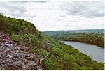
The Metacomet Ridge of southern New England is a narrow and steep fault-block mountain ridge known for its extensive cliff faces, scenic vistas, microclimate ecosystems, and communities of plants considered rare or endangered. An important recreation resource located within 10 miles (16 km) of a population corridor of over 2.5 million people, the ridge is home to four long distance hiking trails and over a dozen parks and recreation areas including several state and nationally recognized historic sites. Because of its natural, historic, and recreational value, the ridge has been the focus of ongoing conservation efforts involving municipal, state, and national agencies as well as nearly two dozen non-profit organizations. The Metacomet Ridge extends from New Haven and Branford, Connecticut on Long Island Sound, through the Connecticut River Valley region of Massachusetts, to northern Franklin County, 2 miles (3.2 km), short of the Vermont and New Hampshire borders, a distance of 100 miles (160 km). Younger and geologically distinct from the nearby Appalachian Mountains and surrounding uplands, the Metacomet Ridge is composed of volcanic basalt, also known as traprock, and sedimentary rock in faulted and tilted layers many hundreds of feet thick. In most, but not all cases, the basalt layers are dominant, prevalent, and exposed.
Selected article 10
Portal:Volcanoes/Selected article/10
The Mount Cayley volcanic field is a remote volcanic zone on the South Coast of British Columbia, Canada, stretching 31 km (19 mi) from the Pemberton Icefield to the Squamish River. It forms a segment of the Garibaldi Volcanic Belt, the Canadian portion of the Cascade Volcanic Arc, which extends from Northern California to southwestern British Columbia. Most of the Cayley volcanoes were formed during periods of volcanism under sheets of glacial ice throughout the last glacial period. These subglacial eruptions formed steep, flat-topped volcanoes and subglacial lava domes, most of which have been entirely exposed by deglaciation. However, at least two volcanoes predate the last glacial period and both are highly eroded. The field gets its name from Mount Cayley, the largest and most persistent volcano, located at the southern end of the Powder Mountain Icefield. This icefield covers much of the central portion of the volcanic field and is one of the several glacial fields in the Pacific Ranges of the Coast Mountains.
Selected article 11
Portal:Volcanoes/Selected article/11
Mount Tambora (or Tomboro) is an active stratovolcano, also known as a composite volcano, on Sumbawa island, Indonesia. Sumbawa is flanked both to the north and south by oceanic crust, and Tambora was formed by the active subduction zones beneath it. This raised Mount Tambora as high as 4,300 m (14,000 ft), making it one of the tallest peaks in the Indonesian archipelago, and drained off a large magma chamber inside the mountain. It took centuries to refill the magma chamber, its volcanic activity reaching its peak in April 1815.The 1815 eruption is rated 7 on the volcanic explosivity index, the only such eruption since the Lake Taupo eruption in about 180 AD. With an estimated ejecta volume of 160 cubic kilometers, Tambora's 1815 outburst was the largest volcanic eruption in recorded history; the explosion was heard on Sumatra island (more than 2,000 km (1,200 mi) away).
Selected article 12
Portal:Volcanoes/Selected article/12
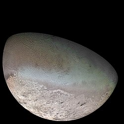
Triton (/ˈtraɪtən/, or as in Greek Τρίτων), is the largest moon of the planet Neptune, discovered on October 10, 1846 by William Lassell. It is the only large moon in the Solar System with a retrograde orbit, which is an orbit in the opposite direction to its planet's rotation. At 2,700 km in diameter, it is the seventh-largest moon in the Solar System. Triton comprises more than 99.5% of all the mass known to orbit Neptune, including the planet's rings and twelve other known moons. It is also more massive than all the Solar System's 159 known smaller moons combined.Because of its retrograde orbit (unique for an object of its size) and similar composition to Pluto, Triton is thought to have been captured from the Kuiper belt. Triton consists of a crust of frozen nitrogen over an icy mantle believed to cover a substantial core of rock and metal. The core makes up two-thirds of its total mass. Triton has a mean density of 2.061 g/cm3 and is composed of approximately 15–35% water ice.
Triton is geologically active; its surface is young and has relatively few impact craters. Although Triton is made of various ices, its subsurface processes are similar to those that produce volcanoes and rift valleys on Earth, but with water and ammonia lavas as opposed to liquid rock. Triton's entire surface is cut by complex valleys and ridges, probably the result of tectonics and icy volcanism.
Selected article 13
Portal:Volcanoes/Selected article/13
Nevado del Ruiz, also known as El Mesa de Herveo or Kumanday, is the northernmost volcano of the Andean Volcanic Belt, lying about 129 kilometers (80 mi) west of Bogotá in the Tolima Department of Colombia. It is a stratovolcano, composed of many layers of lava alternating with hardened volcanic ash and other pyroclastic rocks. Nevado del Ruiz has been active for about two million years, since the early Pleistocene or late Pliocene epoch, with three major eruptive periods. The current volcanic cone formed during the "present" eruptive period, which began 150 thousand years ago.Nevado del Ruiz usually generates Plinian eruptions, which produce swift-moving currents of hot gas and rock called pyroclastic flows. These eruptions often cause massive lahars (mud and debris flows), which pose a threat to human life and the environment. On November 13, 1985, a small eruption produced an enormous lahar that buried and desolated the town of Armero in Tolima Department, causing an estimated 23,000 deaths. This event later became known as the Armero tragedy—the deadliest lahar in recorded history. Similar but less deadly incidents occurred in 1595 and 1845, consisting of a small explosive eruption followed by a large lahar.
Selected article 14
Portal:Volcanoes/Selected article/14 Cerro Azul (blue hill in Spanish), sometimes referred to as Quizapu, is an active stratovolcano in central Chile's Maule Region, immediately south of Descabezado Grande. Part of the South Volcanic Zone of the Andes, it rises 3,788 meters (12,428 ft) and is capped by a summit crater that is 500 meters (1,600 ft) wide and opens to the north. Beneath the summit, the volcano features numerous scoria cones and flank vents.
Cerro Azul is responsible for South America's largest recorded eruptions, in 1846 and 1932. In 1846, an effusive eruption formed the vent at the site of present-day Quizapu Crater on the northern flank of Cerro Azul and sent lava flowing down the sides of the volcano, creating a lava field 8–9 square kilometers (3–3.5 square miles) in area. Phreatic and Strombolian volcanism between 1907 and 1932 excavated this crater. In 1932, one of the largest explosive eruptions of the 20th century occurred at Quizapu Crater and sent 9.5 cubic kilometers (2.3 cu mi) of ash into the atmosphere. The volcano's most recent eruption was in 1967.
The South Volcanic Zone has a long history of eruptions and poses a threat to the surrounding region. Any volcanic hazard—ranging from minor ashfalls to pyroclastic flows—could pose a significant risk to humans and wildlife. Despite its inactivity, Cerro Azul could again produce a major eruption; if this were to happen, relief efforts would probably be quickly organized. Teams such as the Volcanic Disaster Assistance Program (VDAP) are prepared to effectively evacuate, assist, and rescue people threatened by volcanic eruptions.
Selected article 15
Portal:Volcanoes/Selected article/15
Surtsey (Icelandic, meaning "Surtur's island") is a volcanic island off the southern coast of Iceland. At 63°18′11″N 20°36′17″W / 63.303°N 20.6047°W it is also the southernmost point of Iceland. It was formed in a volcanic eruption which began 130 metres (426 ft) below sea level, and reached the surface on 14 November 1963. The eruption lasted until 5 June 1967, when the island reached its maximum size of 2.7 km2 (1.0 sq mi). Since then, wind and wave erosion have caused the island to steadily diminish in size: as of 2002, its surface area was 1.4 km2 (0.54 sq mi).[1]The new island was named after Surtr, a fire jötunn or giant from Norse mythology. It was intensively studied by volcanologists during its eruption, and afterwards by botanists and biologists as life forms gradually colonised the originally barren island. The undersea vents that produced Surtsey are part of the Vestmannaeyjar (Westmann Isles) submarine volcanic system, part of the fissure of the sea floor called the Mid-Atlantic Ridge. Vestmannaeyjar also produced the famous eruption of Eldfell on the island of Heimaey in 1973. The eruption that created Surtsey also created a few other small islands along this volcanic chain, such as Jólnir and other, unnamed peaks. Most of these eroded away fairly quickly.
Selected article 16
Portal:Volcanoes/Selected article/16
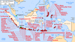
The volcanoes of Indonesia are a dominating feature of the geography of Indonesia. The volcanoes formed due to subduction zones between the Eurasian plate and the Indo-Australian plate. Some of the volcanoes are notable for their eruptions, for instance, Krakatau for its global effects in 1883, Lake Toba for its supervolcanic eruption estimated to have occurred 74,000 Before Present which was responsible for six years of volcanic winter, and Mount Tambora for the most violent eruption in recorded history in 1815.Volcanoes in Indonesia are a part of the Pacific Ring of Fire. The 150 entries in the list below are grouped into six geographical regions, four of which belong to the volcanoes of the Sunda Arc trench system. The remaining two groups are volcanoes of Halmahera, including its surrounding volcanic islands, and volcanoes of Sulawesi and the Sangihe Islands. The latter group is in one volcanic arc together with the Philippine volcanoes.
Selected article 17
Portal:Volcanoes/Selected article/17
The Volcano, also known as Lava Fork volcano, is a small cinder cone in the Boundary Ranges of the Coast Mountains in northwestern British Columbia, Canada. It is located approximately 60 km (40 mi) northwest of the small community of Stewart near the head of Lava Fork. With a summit elevation of 1,330 m (4,360 ft) and a topographic prominence of 311 m (1,020 ft), it rises above the surrounding rugged landscape on a remote mountain ridge that represents the northern flank of a glaciated U-shaped valley.Lava Fork volcano is associated with a small group of related volcanoes called the Iskut-Unuk River Cones. This forms part of the much larger Northern Cordilleran Volcanic Province, which extends from the Alaska-Yukon border to near Prince Rupert, British Columbia. Eruptive activity at The Volcano is relatively young compared to most other volcanoes in the Northern Cordilleran Volcanic Province. Geologic studies have shown that The Volcano and its eruptive products were emplaced in the past 400 years; this is well after the last glacial period, which ended about 10,000 years ago.
- ^ Jakobsson, Sveinn P. (2007-05-06), Surtsey — Geology, The Surtsey Research Society, retrieved 2008-07-08


