
Poortvliet
Poortvliet | |
|---|---|
Village | |
 The St Pancratius Church | |
 Flag  Coat of arms | |
 Poortvliet Location in the province of Zeeland in the Netherlands  Poortvliet Poortvliet (Netherlands) | |
| Coordinates: 51°32′40″N 4°8′39″E / 51.54444°N 4.14417°E | |
| Country | Netherlands |
| Province | Zeeland |
| Municipality | Tholen |
| Area | |
| • Total | 22.18 km2 (8.56 sq mi) |
| Elevation | −0.5 m (−1.6 ft) |
| Population (2021)[1] | |
| • Total | 1,715 |
| • Density | 77/km2 (200/sq mi) |
| Time zone | UTC+1 (CET) |
| • Summer (DST) | UTC+2 (CEST) |
| Postal code | 4693[1] |
| Dialing code | 0166 |
Poortvliet (Dutch pronunciation: [ˈpoːrtflit]; Zeelandic: Poôfliet) is a village in the Dutch province of Zeeland. It is a part of the municipality of Tholen and lies about 12 km northwest of Bergen op Zoom.
History[edit]
The village was first mentioned in 1200 as Portfliet, and the name is a combination of words for port and streaming water.[3] Poortvliet is a circular church village. The Poortvlietpolder and the Mallandpolder are the oldest diked polders of the former island of Tholen.[4]
The Dutch Reformed church is a basilica like cruciform church which was dedicated to St Pancratius. The lower parts of the tower date from around 1350. The church was rebuilt after a fire in 1586. During a restoration in 1778, the entire choir was removed.[4]
The grist mill De Korenaar was built in 1710. The wind mill started to lean during construction and is smaller than intended. In 2010s, the displacement was 66 centimeters. In 1950, an electro motor was installed. In 2010, it was restored and back in service until 2018.[5]
Poortvliet was home to 1,113 people in 1840.[6] Poortvliet was evacuated and inundated in 1944. In 1945, it was hit by V-1 flying bomb intended for Antwerp which killed four people. Poortvliet was severely affected by the North Sea flood of 1953.[7]
In 1813, the village of Nieuw-Strijen was merged with Poortvliet.[8] Poortvliet remained a separate municipality until 1971, when it was merged with Tholen.[8]
Gallery[edit]
-
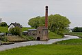 Steam pumping station Oosterschelde
 -
 Wind mill De Korenaar
 -
 Entrance to the church
 -
 Farm in Poortvliet


References[edit]
- ^ a b c "Kerncijfers wijken en buurten 2021". Central Bureau of Statistics. Retrieved 22 April 2022.
- ^ "Postcodetool for 4693BA". Actueel Hoogtebestand Nederland (in Dutch). Het Waterschapshuis. Retrieved 22 April 2022.
- ^ "Poortvliet - (geografische naam)". Etymologiebank (in Dutch). Retrieved 22 April 2022.
- ^ a b Piet van Cruyningen & Ronald Stenvert (2003). Poortvliet (in Dutch). Zwolle: Waanders. ISBN 90 400 8830 6. Retrieved 22 April 2022.
- ^ "De Korenaar". Molendatabase (in Dutch). Retrieved 22 April 2022.
- ^ "Poortvliet". Plaatsengids (in Dutch). Retrieved 22 April 2022.
- ^ "Poortvliet". Zalig Zeeland (in Dutch). Retrieved 22 April 2022.
- ^ a b Ad van der Meer and Onno Boonstra, Repertorium van Nederlandse gemeenten, KNAW, 2011.
| International | |
|---|---|
| National | |
| Geographic | |