
Perry Downtown Historic District
Perry Downtown Historic District | |
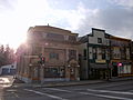
 Perry Downtown Historic District, April 2020 | |
  | |
| Location | N. & S. Main, Covington, & Lake Sts., Borden Ave., Perry, New York |
|---|---|
| Coordinates | 42°43′06″N 78°00′07″W / 42.71833°N 78.00194°W |
| Area | 8.5 acres (3.4 ha) |
| Architectural style | Mixed |
| NRHP reference No. | 12000212[1] |
| Added to NRHP | November 21, 2012 |
Perry Downtown Historic District is a national historic district located at Perry in Wyoming County, New York. The district encompasses 41 contributing buildings in the village of Perry. They are a variety of commercial, institutional, and governmental buildings with most built between 1850 and 1918. Most of the commercial buildings are two-stories and constructed of brick. They include the Town Hall (1909), Masonic Temple (1914), Bussey Block (1898), Bailey-Roche Block (c. 1836), A. Cole and Wygant Building (1867), Garrison Building (1901), Rufus Smith Block (1856), Howell Building (1895), Traver Place Apartments (1924), and the Wise Building (1903).[2]
It was listed on the National Register of Historic Places in 2012.[1]
Gallery[edit]
-
 Perry Town Hall and Commercial Buildings, Perry Downtown Historic District, Perry, New York, November 2010

References[edit]
- ^ a b "National Register of Historic Places Listings". Weekly List of Actions Taken on Properties: 4/16/12 through 4/20/12. National Park Service. April 27, 2012.
- ^ Robert T. Englert (September 2011). "National Register of Historic Places Registration: Perry Downtown Historic District". New York State Office of Parks, Recreation and Historic Preservation. Retrieved April 20, 2013. See also: "Accompanying seven photos".
