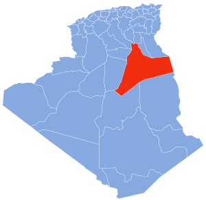
Oum Zebed
Oum Zebed | |
|---|---|
Village | |
| Coordinates: 33°9′17″N 6°17′58″E / 33.15472°N 6.29944°E | |
| Country | |
| Province | Ouargla Province |
| District | Taibet District |
| Commune | M'Naguer[1] |
| Elevation | 100 m (300 ft) |
| Time zone | UTC+1 (CET) |
Oum Zebed (also known as Oum ez Zebed el djadida ) is a village in the commune of M'Naguer,[1] in Taibet District, Ouargla Province, Algeria. The village is located 5 kilometres (3.1 mi) northwest of M'Naguer and 27 kilometres (17 mi) east of Touggourt.[2]
This section is empty. You can help by adding to it. (June 2016) |
population[edit]
people of oum zebed belong to Arch "Ouled Sayah" (Arch means clan ),named after the ancestor of these people and many others in the region nearby, who is Sidi Mohammed Sayah originally from telemcen city, he was called sayah which means " voyager " because of his journeys from telemcen towards many placese,
References[edit]
- ^ a b "Décret n° 84-365, fixant la composition, la consistance et les limites territoriale des communes. Wilaya d'El Oued" (PDF) (in French). Journal officiel de la République Algérienne. 19 December 1984. p. 1551. Archived from the original (PDF) on 2 March 2013. Retrieved 2 March 2013.
- ^ "Oum ez Zebed, Algeria". Google Maps. Retrieved 4 May 2013.
Neighbouring towns and cities


