
Oprtalj
Oprtalj | |
|---|---|
Municipality | |
| Oprtalj Municipality Općina Oprtalj - Comune di Portole[1] | |
 Oprtalj, panoramic view | |
 Flag | |
 Oprtalj | |
| Coordinates: 45°23′N 13°50′E / 45.383°N 13.833°E | |
| Country | |
| County | |
| Government | |
| • Mayor | Aleksandar Krt |
| Area | |
| • Municipality | 60.3 km2 (23.3 sq mi) |
| • Urban | 4.4 km2 (1.7 sq mi) |
| Population (2021)[3] | |
| • Municipality | 748 |
| • Density | 12/km2 (32/sq mi) |
| • Urban | 75 |
| • Urban density | 17/km2 (44/sq mi) |
| Time zone | UTC+1 (CET) |
| • Summer (DST) | UTC+2 (CEST) |
| Postal code | 52428 |
| Area code | 052 |
| Website | oprtalj |
Oprtalj (Italian: Portole) is a village and municipality in Istria, Croatia. Oprtalj is a community in the central northern part of Istria County, situated across the Mirna river valley from the village of Motovun, about 20 km northwest of Pazin.
Oprtalj used to be a fortress surrounded by walls. In front of the former door, there is a large Venetian loggia with a lapidary. [4]
Demographics[edit]
According to the 2021 census, its population was 748, with 75 living in the village proper.[3] At the 2011 census it was 850.[5]
Gallery[edit]
-
 Church of Our Lady of the Greeks
 -
 Oprtalj cypress tree-lined road
 -
 Čabrnica/Zabarnizza
 -
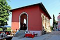 Oprtalj Loggia
 -
 Church of Saint George


References[edit]
- ^ The official site, see also the list of towns and municipalities Archived 2014-03-11 at the Wayback Machine in the Istria County (ref. to [1]) and the narodne-novine list (ref. to [2])
- ^ Register of spatial units of the State Geodetic Administration of the Republic of Croatia. Wikidata Q119585703.
- ^ a b "Population by Age and Sex, by Settlements, 2021 Census". Census of Population, Households and Dwellings in 2021. Zagreb: Croatian Bureau of Statistics. 2022.
- ^ "ISTRA.HR". www.istra.hr (in Croatian). Retrieved 2023-04-29.
- ^ "Population by Age and Sex, by Settlements, 2011 Census: Oprtalj". Census of Population, Households and Dwellings 2011. Zagreb: Croatian Bureau of Statistics. December 2012.
External links[edit]
Wikimedia Commons has media related to Oprtalj.
Subdivisions of Istria County | ||
|---|---|---|
| Cities and towns |  | |
| Municipalities | ||
| International | |
|---|---|
| National | |
This Istria County geography article is a stub. You can help Wikipedia by expanding it. |