
Nitta Yuma, Mississippi
Nitta Yuma, Mississippi | |
|---|---|
 | |
 Nitta Yuma  Nitta Yuma | |
| Coordinates: 33°01′27″N 90°50′57″W / 33.02417°N 90.84917°W | |
| Country | United States |
| State | Mississippi |
| County | Sharkey |
| Area | |
| • Total | 0.19 sq mi (0.50 km2) |
| • Land | 0.19 sq mi (0.50 km2) |
| • Water | 0.00 sq mi (0.00 km2) |
| Elevation | 112 ft (34 m) |
| Population (2020) | |
| • Total | 8 |
| • Density | 41.67/sq mi (16.10/km2) |
| Time zone | UTC-6 (Central (CST)) |
| • Summer (DST) | UTC-5 (CDT) |
| Area code | 662 |
| GNIS feature ID | 674927[2] |
Nitta Yuma is a census-designated place and unincorporated community located in Sharkey County, Mississippi, United States.[2] Nitta Yuma is located along U.S. Route 61, approximately four miles north of Anguilla.
The name "Nitta Yuma" is derived from the Choctaw language.[3] The Choctaw had long occupied this area, for thousands of years before Europeans. The Vick and Willis families developed cotton plantations on Deer Creek after they were first surveyed and offered for sale by the federal government.[4]
It was first named as a CDP in the 2020 Census which listed a population of 8.[5]
Demographics[edit]
| Census | Pop. | Note | %± |
|---|---|---|---|
| 2020 | 8 | — | |
| U.S. Decennial Census[6] 2020[7] | |||
2020 census[edit]
| Race / Ethnicity (NH = Non-Hispanic) | Pop 2020[7] | % 2020 |
|---|---|---|
| White alone (NH) | 0 | 0.00% |
| Black or African American alone (NH) | 6 | 75.00% |
| Native American or Alaska Native alone (NH) | 0 | 0.00% |
| Asian alone (NH) | 0 | 0.00% |
| Pacific Islander alone (NH) | 0 | 0.00% |
| Some Other Race alone (NH) | 0 | 0.00% |
| Mixed Race or Multi-Racial (NH) | 0 | 0.00% |
| Hispanic or Latino (any race) | 2 | 25.00% |
| Total | 8 | 100.00% |
Climate[edit]
The climate in this area is characterized by relatively high temperatures and evenly distributed precipitation throughout the year. According to the Köppen Climate Classification system, Nitta Yuma has a Humid subtropical climate, abbreviated "Cfa" on climate maps.[8]
Education[edit]
It is a part of the South Delta School District,[9] which operates South Delta High School.
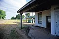
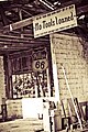
Gallery[edit]
-
-
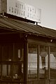 An old Nitta Yuma gas station. Picture taken while driving up 61 North
 -


References[edit]
- ^ "2020 U.S. Gazetteer Files". United States Census Bureau. Retrieved July 24, 2022.
- ^ a b "Nitta Yuma, Mississippi". Geographic Names Information System. United States Geological Survey, United States Department of the Interior.
- ^ Baca, Keith A. (2007). Native American Place Names in Mississippi. University Press of Mississippi. p. 64. ISBN 978-1-60473-483-6.
- ^ Mrs. Henry Vick Phelps (Dorothy Cole) and Henry Vick Phelps II. (1974). Nitta Yuma king cotton. Nitta Yuma, Ms: D.C. Phelps. p. 22 f.
- ^ "Nitta Yuma CDP, Mississippi". United States Census Bureau. Retrieved March 13, 2022.
- ^ "Decennial Census of Population and Housing by Decades". US Census Bureau.
- ^ a b "P2 HISPANIC OR LATINO, AND NOT HISPANIC OR LATINO BY RACE - 2020: DEC Redistricting Data (PL 94-171) - Nitta Yuma CDP, Mississippi". United States Census Bureau.
- ^ Climate Summary for Nitta Yuma
- ^ "2020 CENSUS - SCHOOL DISTRICT REFERENCE MAP: Sharkey County, MS" (PDF). U.S. Census Bureau. Retrieved June 9, 2021.
External links[edit]
Municipalities and communities of Sharkey County, Mississippi, United States | ||
|---|---|---|
| City |  | |
| Towns | ||
| CDPs | ||
| Other communities | ||
This Sharkey County, Mississippi state location article is a stub. You can help Wikipedia by expanding it. |