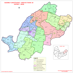
Neem Ka Thana
This article has multiple issues. Please help improve it or discuss these issues on the talk page. (Learn how and when to remove these messages)
|
Neem Ka Thana | |
|---|---|
City | |
 Neem Ka Thana | |
| Coordinates: 27°44′06″N 75°46′47″E / 27.735018°N 75.779730°E | |
| Country | |
| State | Rajasthan |
| District | Neem Ka Thana |
| Government | |
| • M.L.A. | Suresh Modi |
| Elevation | 446 m (1,463 ft) |
| Population | |
• Total | 36,000 |
| Languages | |
| • Official | Dhundhari, Hindi, Rajasthani |
| • Spoken | Shekhawati & Torawati |
| Time zone | UTC+5:30 (IST) |
| PIN | 332713 |
| ISO 3166 code | RJ-IN |
| Vehicle registration | RJ-23B |
| Website | https://neemkathana.rajasthan.gov.in/ |
Neem Ka Thana is a city and administrative headquarter of Neem Ka Thana district located 73 km from Sikar City in the Dhundhar region in the Rajasthan state of India.[1] Sikar, Khandela, Sri Madhopur, Kotputli, Khetri, and Narnaul are some major cities and towns near Neem Ka Thana. It is located at a distance of 119 kilometers from Jaipur and 241 kilometers from Delhi. Neem Ka Thana is well connected with others cities in the region with roads and Indian Railways.
Demographics
[edit]As of 2011[update] Indian census,[2] Neem-Ka-Thana had a population 36,000 males constituting 53% of the population and females 47%.16% of the population is under 6 years of age. It has an average literacy rate of 67%, higher than the national average of 59.5%. Male literacy is 77%, and female literacy is 56%. Neem ka thana is an important commercial center of Shekhawati region of Rajasthan. The total area of the current Neem Ka Thana station district in 1016 hectares (as of 2015, when it was a municipality).
Total Male Female Children (Age 0-6) 58,707 31,710 26,997 Literacy 71.09% 71.87% 48.31% Scheduled Caste 57,665 30,350 27,315 Scheduled Tribe 27,361 14,378 12,983 Illiterate 157,348 58,937 98,4
References
[edit]- ^ "सीकर अब जिला नहीं संभाग हुआ:नीमकाथाना अब अलग जिला,बजट पास में CM की सीकर के लिए 2 बड़ी घोषणा". Dainik Bhaskar.
- ^ "Census of India 2011: Data from the 2011 Census, including cities, villages and towns (Provisional)". Census Commission of India. Archived from the original on 16 June 2004. Retrieved 1 November 2008.
2. https://www.bhaskar.com/amp/news/vishnu-chetani-becomes-bjp-district-president-0868534.html

