
Nanfaxin, Beijing
Nanfaxin Area
南法信地区 Nanfaxin Town (南法信镇) | |
|---|---|
.jpg) Shunping Highway that passes through the town, 2017 | |
.png) Location of Nanfaxin Area within Shunyi District | |
 Nanfaxin Area  Nanfaxin Area | |
| Coordinates: 40°07′05″N 116°36′17″E / 40.11806°N 116.60472°E | |
| Country | China |
| Municipality | Beijing |
| District | Shunyi |
| Village-level Divisions | 1 communities 16 villages |
| Area | |
| • Total | 20.74 km2 (8.01 sq mi) |
| Elevation | 34 m (112 ft) |
| Population (2020) | |
| • Total | 54,195 |
| • Density | 2,600/km2 (6,800/sq mi) |
| Time zone | UTC+8 (China Standard) |
| Postal code | 101300 |
| Area code | 010 |
Nanfaxin Area (simplified Chinese: 南法信地区; traditional Chinese: 南法信地區; pinyin: Nánfǎxìn Dìqū) is an area and a town in western Shunyi District, Beijing, China. It borders Mapo Town and Shuangfeng Subdistrict to its north, Wangquan Subdistrict and Renhe Town to its east, Capital Airport Subdistrict to its south, Houshayu and Gaoliying Towns to its west. The 2020 Chinese census counted 54,195 residents for the area.[1]
The settlement here used to be called Faxin Village, named after the two dominant families, Fa (法) and Xin (信), within the region. During the Ming dynasty, many villagers moved north and established another Faxin Village, so this region was renamed Nanfaxin (Chinese: 南法信; lit. 'South Faxin') to avoid confusion.[2]
History[edit]
| Year | Status | Under |
|---|---|---|
| 1937–1946 | 6th District | Luanchanghuai and Huaishun United County |
| 1946–1947 | 2nd District | Shunyi County |
| 1947–1949 | Changshun United County | |
| 1949–1951 | 1st District | Shunyi County |
| 1951–1961 | Nanfaxin Township | |
| 1961–1965 | Nanfaxin People's Commune | |
| 1965–1975 | Part of Chengguan People's Commune | |
| 1975–1983 | Nanfaxin People's Commune | |
| 1983–1998 | Nanfaxin Township | |
| 1998–2000 | Nanfaxin Area | Shunyi District |
| 2000–present | Nanfaxin Area (Nanfaxin Town) |
Administrative divisions[edit]
In 2021, Nanfaxin Area was made up of 17 subdivisions, in which 1 was a community and 16 were villages:[3]
| Administrative Division Code | Subdisvision Names | Name Transliteration | Type |
|---|---|---|---|
| 110113008001 | 华英园 | Huayingyuan | Community |
| 110113008201 | 东海洪 | Dong Haihong | Village |
| 110113008202 | 西海洪 | Xi Haihong | Village |
| 110113008203 | 南卷 | Nanjuan | Village |
| 110113008204 | 三家店 | Sanjiadian | Village |
| 110113008205 | 东杜兰 | Dong Dulan | Village |
| 110113008206 | 西杜兰 | Xi Dulan | Village |
| 110113008207 | 北法信 | Bei Faxin | Village |
| 110113008208 | 焦各庄 | Jiaogezhuang | Village |
| 110113008209 | 大江洼 | Dajiangwan | Village |
| 110113008210 | 刘家河 | Liujiahe | Village |
| 110113008211 | 南法信 | Nan Faxin | Village |
| 110113008212 | 十里堡 | Shilibao | Village |
| 110113008213 | 马家营 | Majiaying | Village |
| 110113008214 | 哨马营 | Shaomaying | Village |
| 110113008215 | 冯家营 | Fenjiaying | Village |
| 110113008216 | 卸甲营 | Xiejiaying | Village |
Gallery[edit]
-
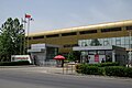 Beijing Air Catering headquarters, 2017
 -
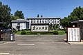 Buildling of Nanfaxin People's Government, 2019
 -
 Nanfaxin Station of Beijing Subway, 2021
.jpg)
.jpg)
.jpg)
See also[edit]
References[edit]
- ^ "北京市顺义区第七次全国人口普查公报发布". ie.bjd.com.cn (in Chinese (China)). Retrieved 2022-10-14.
- ^ a b 李立国; 李万钧; 吴世民, eds. (2013). 中华人民共和国政区大典, 北京市卷. Beijing: 中国社会出版社. ISBN 978-7-5087-4058-4. OCLC 910451741.
- ^ "2021年统计用区划代码和城乡划分代码". www.stats.gov.cn. Retrieved 2022-10-15.
This Beijing location article is a stub. You can help Wikipedia by expanding it. |