
Naguru, Uganda
Naguru | |
|---|---|
| Nickname: Naggulu | |
 Naguru Map of Kampala showing the location of Naguru | |
| Coordinates: 00°20′48″N 32°36′20″E / 0.34667°N 32.60556°E | |
| Country | |
| Region | Central Uganda |
| District | Kampala District |
| Division | Nakawa Division |
| Elevation | 1,300 m (4,300 ft) |
| Time zone | UTC+3 (EAT) |
Naguru, also Naggulu, is a hill in Kampala, the capital and largest city in Uganda. The name also applies to the commercial and residential neighborhoods that sit on that hill.
Location[edit]
Naguru is located in Nakawa Division, in the northeastern part of the city. It is bordered by Ntinda to the east, Nakawa to the southeast, Namuwongo to the south, Kololo to the southwest, Kamwookya to the west, Bukoto to the northwest and Kigoowa to the north. Its location is approximately 4.5 kilometres (2.8 mi), northeast of Kampala's central business district.[1] The coordinates of Naguru Hill are:00 20 48N, 32 36 20E (Latitude:0.34653331; Longitude:32.6055).[2]
Overview[edit]
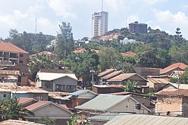
Naggulu Hill rises 1,300 metres (4,300 ft) above sea level. The view from this hill is incredible; one can see the tops of most of the other hills: Kololo, Muyenga, Mbuya and Mutungo. The top of the hill houses radio and telecommunication masts for the many communication companies in the city. The upper reaches of the hill are also the location of upscale residential mansions with manicured lawns. The well-landscaped hill also boasts of good guesthouses and recreation centers. These include: (a) Lugogo Rugby Club (b) Lugogo Tennis Club and (c) Lugogo Cricket Club. At the base of the hill is the Uganda Manufacturers Association (UMA) show ground, where the annual trade fairs are staged. On the southeastern slopes of the hill, the headquarters of Uganda National Police are located. There is a reservoir water tank belonging to National Water and Sewerage Corporation (NWSC), at the summit.[3]
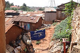
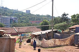
- Slums in Naguru.
-
-

-

-
-


Points of interest[edit]
The following points of interest lie on Naguru Hill or near its edges:
- The headquarters of the Uganda National Police
- The headquarters of the Uganda Ministry of Justice and Constitutional Affairs - In development.[4]
- Naguru Sanyu Babies Home - A private orphanage administered by Sanyu Babies Homes, an NGO.
- Naguru Housing Estate - A public housing project, destined for demolition and modernization[5][6]
- Naguru General Hospital - A 200-bed public hospital built with assistance of the Chinese Government and administered by the Uganda Ministry of Health.[7]
- Panamera Bar & Restaurant[citation needed]
- Protea Hotel Naguru Skyz[8]
- Protea Hotel Pinnacle[8]
See also[edit]
References[edit]
- ^ "Distance Between Naguru And Central Kampala With Map". Globefeed.com. Retrieved 20 June 2014.
- ^ Google (20 June 2014). "Location of Naguru At Google Maps" (Map). Google Maps. Google. Retrieved 20 June 2014.
- ^ "Profile of Naguru Hill". Uganda Travel Guide. Retrieved 21 June 2014.
- ^ Malaba, Tom (25 July 2013). "Police Give Away Part Of Naguru Land To JLOS". Uganda Radio Network (URN). Retrieved 21 June 2014.
- ^ Musisi, Frederic (16 May 2013). "Shs4 Trillion Nakawa-Naguru Housing Project Set To Kick Off". Daily Monitor. Retrieved 21 June 2014.
- ^ Musoke, Cyprian; Magara, Darius (14 October 2013). "Museveni Launches Naguru Housing Estate Project". New Vision. Retrieved 21 June 2014.
- ^ Kiwawulo, Chris (27 September 2009). "Naguru Hospital To Ease Congestion of Mulago". New Vision. Archived from the original on 8 January 2014. Retrieved 21 June 2014.
- ^ a b Property24.com News (11 Mar 2016). "Two new Protea Hotels to open in Uganda". Property24.com. Retrieved 30 January 2018.
{{cite web}}: CS1 maint: numeric names: authors list (link)
External links[edit]
- David Adjaye Designs Office Campus for New 65 hectares (160 acres) Development In Uganda
- The Two Faces of Naguru
