
Mount Sumdum
| Mount Sumdum | |
|---|---|
 Southwest aspect | |
| Highest point | |
| Elevation | 6,666 ft (2,032 m)[1][2] |
| Prominence | 3,516 ft (1,072 m)[1] |
| Parent peak | Peak 7160[1] |
| Isolation | 13.31 mi (21.42 km)[1] |
| Coordinates | 57°48′22″N 133°26′14″W / 57.8061902°N 133.4371853°W[3] |
| Geography | |
 Mount Sumdum Location of Mount Sumdum in Alaska | |
| Country | United States |
| State | Alaska |
| Borough | Petersburg |
| Protected area | Tracy Arm-Fords Terror Wilderness Tongass National Forest |
| Parent range | Coast Mountains Boundary Ranges[4] |
| Topo map | USGS Sumdum D-5 |
| Geology | |
| Type of rock | Metamorphic rock[5] |
| Climbing | |
| Easiest route | class 3[1] Scrambling |
Mount Sumdum is a 6,666-foot-elevation (2,032-meter) mountain summit in Alaska, United States.
Description[edit]
Mount Sumdum is located 50 miles (80 km) southeast of Juneau in the Boundary Ranges of the Coast Mountains.[3] It is set within the Tracy Arm-Fords Terror Wilderness on land managed by Tongass National Forest.[1] Precipitation runoff and glacial meltwater from the mountain drains to Tracy Arm and Endicott Arm. Although modest in elevation, topographic relief is significant as the summit rises 6,666 feet (2,032 m) above tidewater of each arm in 4.5 miles (7.2 km). The mountain's toponym has been officially adopted by the United States Board on Geographic Names.[3] The mountain is named for the Sumdum Glacier on its southern flank and the toponym was published in 1895 by the United States Coast and Geodetic Survey.[2] "Sumdum" is a Tlingit name which represents the booming sound of icebergs as they break off from the glacier.[6]
Climate[edit]
Based on the Köppen climate classification, Mount Sumdum has a tundra climate with long, cold, snowy winters, and mild summers.[7] Weather systems coming off the Gulf of Alaska are forced upwards by the Coast Mountains (orographic lift), causing heavy precipitation in the form of rainfall and snowfall. Winter temperatures can drop to 0 °F with wind chill factors below −10 °F. This climate supports the Sumdum Glacier on the peak's south flank as well as smaller unnamed glaciers on the surrounding slopes.
See also[edit]
Gallery[edit]
-
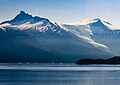 Mt. Sumdum and Sumdum Glacier
 -
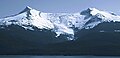
 Mt. Sumdum and Sumdum Glacier
 -
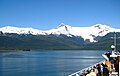
 Mt. Sumdum, west aspect from Holkham Bay
 -
-
 Sumdum Glacier
 -


References[edit]
- ^ a b c d e f "Sumdum, Mount - 6,666' AK". listsofjohn.com. Retrieved 2024-01-02.
- ^ a b Donald J. Orth, Dictionary of Alaska Place Names, U.S. Government Printing Office, 1967, page 928.
- ^ a b c "Mount Sumdum". Geographic Names Information System. United States Geological Survey, United States Department of the Interior. Retrieved 2024-01-02.
- ^ "Mount Sumdum, Alaska". Peakbagger.com. Retrieved 2024-01-02.
- ^ Geology of the Sumdum Copper-Zinc Prospect Southeastern Alaska, USGS Bulletin 1108-E, US Government Printing Office, 1964, p. E6.
- ^ "Sumdum Glacier". Geographic Names Information System. United States Geological Survey, United States Department of the Interior. Retrieved 2024-01-02.
- ^ Peel, M. C.; Finlayson, B. L.; McMahon, T. A. (2007). "Updated world map of the Köppen−Geiger climate classification". Hydrol. Earth Syst. Sci. 11. ISSN 1027-5606.
External links[edit]
- Mount Sumdum: weather forecast
- Mt. Sumdum (photo): Flickr
Places adjacent to Mount Sumdum | ||||||||||||||||
|---|---|---|---|---|---|---|---|---|---|---|---|---|---|---|---|---|
| ||||||||||||||||