
Mount Judah
| Mount Judah | |
|---|---|
 Approaching the summit | |
| Highest point | |
| Elevation | 8,243 ft (2,512 m)[1][2] |
| Prominence | 363 ft (111 m)[3] |
| Parent peak | Mount Lincoln (8,383 ft)[4] |
| Isolation | 1.01 mi (1.63 km)[4] |
| Coordinates | 39°17′55″N 120°18′56″W / 39.2985278°N 120.3155723°W[5] |
| Naming | |
| Etymology | Theodore Dehone Judah[2] |
| Geography | |
 Mount Judah Location in California  Mount Judah Mount Judah (the United States) | |
| Location | Donner Pass |
| Country | United States of America |
| State | California |
| County | Placer |
| Parent range | Sierra Nevada[3] |
| Topo map | USGS Norden |
| Climbing | |
| Easiest route | class 1 trail[4] |
Mount Judah is an 8,243-foot-elevation (2,512 meter) mountain summit in Placer County, California, United States.
Description[edit]
Mount Judah is located one mile southeast of Donner Pass at Sugar Bowl Ski Resort, on land managed by Tahoe National Forest. It is situated on the crest of the Sierra Nevada mountain range, with precipitation runoff from the peak draining west to South Yuba River, and east to the Truckee River. Topographic relief is modest as the summit rises 1,480 feet (450 meters) above Lakeview Canyon in one mile. Neighbors include Donner Peak, 0.7 miles (1.1 km) to the north, Mount Disney 1.4 miles (2.3 km) west, and the nearest higher peak is Mount Lincoln, one mile (1.6 km) to the southwest. The Pacific Crest Trail traverses the west slope of the peak, providing an approach option from Donner Pass. The 4.35-mile Mt. Judah Loop Trail takes hikers across the summit, and is the most popular trail in the Donner Pass area.[6]
History[edit]

This landform's toponym was officially adopted October 18, 1940, by the U.S. Board on Geographic Names to honor Theodore Judah (1826–1863), an American civil engineer who played a leading part in the promotion and design of the First Transcontinental Railroad.[7]
President Abraham Lincoln supported a transcontinental railroad to Northern California, and in 1862 signed the Pacific Railroad Acts to begin construction. The Sierra Nevada posed a major obstacle to the project, and Theodore Judah decided the best route for the railroad was through Donner Pass as it required only one summit crossing rather than two required of other possible options. The 1865 route originally traversed steep cliffs of Donner Peak via tunnels and snow sheds before the 10,322-foot-long (3,146 m) Tunnel #41 running under Mount Judah opened in 1925.
The California Trail, which crossed Roller Pass between Mount Lincoln and Mount Judah, was one of the wagon trails through Donner Pass used by pioneers on the way to Sutter's Fort. In April 1846, 90 people departed Springfield, Illinois, en route to California. The ill-fated journey of the Donner Party tragically ended nearby when they were snowbound at Donner Lake before they could cross this pass.
Climate[edit]
According to the Köppen climate classification system, Mount Judah is located in an alpine climate zone.[8] Most weather fronts originate in the Pacific Ocean and travel east toward the Sierra Nevada mountains. As fronts approach, they are forced upward by the peaks (orographic lift), causing them to drop their moisture in the form of rain or snowfall onto the range. Donner Pass averages 51.6 inches (1,310 mm) of precipitation per year,[9] and with an average of 411.5 inches (10.45 m) of snow per year, it is one of the snowiest places in the contiguous United States.[10] This climate supports five ski areas at Donner Pass.
Gallery[edit]
-
 East aspect seen from the California Zephyr
 -
 Mt. Judah (upper left), Donner Peak centered, from Donner Lake
 -
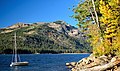 Boat's mast pointed at reddish Mount Judah.
Donner Peak centered, from Donner Lake -
 Ascending Mt. Judah from the col with Donner Peak
 -
 Climbing to the summit in winter
 -
 Mt. Judah upper left, from Donner Lake.
Collodion process image, circa 1870. -
 Mt. Judah centerd


See also[edit]
References[edit]
- ^ United States Geological Survey topographical map - Norden
- ^ a b Matt Johanson (2019), Sierra Summits: A Guide to Fifty Peak Experiences in California's Range of Light, Falcon Guides, ISBN 9781493036455, p. 43
- ^ a b "Mount Judah, California". Peakbagger.com. Retrieved 2022-07-07.
- ^ a b c "Judah, Mount - 8,243' CA". listsofjohn.com. Retrieved 2022-07-07.
- ^ "Mount Judah". Geographic Names Information System. United States Geological Survey, United States Department of the Interior. Retrieved 2022-07-07.
- ^ Mt. Judah Loop Trail, Donner Summit Historical Society
- ^ Decisions of United States Board on Geugraphical Names, Decisions Rendered Between July 1, 1940 and June 30, 1941, US Government Printing Office, 1942, p. 27
- ^ "Climate of the Sierra Nevada". Encyclopædia Britannica.
- ^ "Climate Summary of Donner Summit, California 1870–2001". Journal of the Sierra College Natural History Museum. 2 (1). Winter 2009.
- ^ "Donner Summit Snowfall and Snowpack 1879–2011". Central Sierra Snow Laboratory. University of California, Berkeley.
External links[edit]
- Weather forecast: Mount Judah
- Mt. Judah Loop Trail: Outdoorproject.com