
Mount Eisen
| Mount Eisen | |
|---|---|
 North summit at sunrise | |
| Highest point | |
| Elevation | 12,185 ft (3,714 m)[1] |
| Prominence | 480 ft (150 m)[2] |
| Parent peak | Lippincott Mountain (12,265 ft)[3] |
| Isolation | 1.63 mi (2.62 km)[3] |
| Listing | Sierra Peaks Section |
| Coordinates | 36°29′54″N 118°34′07″W / 36.4982813°N 118.5685054°W[1] |
| Naming | |
| Etymology | Gustav Eisen |
| Geography | |
 Mount Eisen Location in California  Mount Eisen Mount Eisen (the United States) | |
| Location | Sequoia National Park Tulare County California, U.S. |
| Parent range | Sierra Nevada Great Western Divide[2] |
| Topo map | USGS Mineral King |
| Geology | |
| Age of rock | Cretaceous |
| Mountain type | Fault block |
| Type of rock | granitic |
| Climbing | |
| First ascent | 1949 |
| Easiest route | class 2[3] Southeast ridge[4] |
Mount Eisen is a 12,185-foot-elevation (3,714-meter) double summit mountain located on the Great Western Divide of the Sierra Nevada mountain range, in Tulare County of northern California.[1] It is situated in Sequoia National Park, 1.6 miles (2.6 km) south of Lippincott Mountain. Mount Eisen ranks as the 380th highest summit in California.[3] Topographic relief is significant as the south aspect rises 3,500 feet (1,100 meters) above Pinto Lake in one mile. The summit can be reached from the southeast ridge via a long class 2 hike from Black Rock Pass.[5]
History[edit]
This mountain was named by the National Park Service, and officially adopted in 1941 by the United States Board on Geographic Names to remember Gustav Eisen (1847–1940), scientist and early conservationist, who played an important role in the establishment of Sequoia National Park.[1] He was a Sierra Club member for 48 years, and his ashes are interred on the north side of the mountain near Redwood Meadow.[6] The first ascent of the summit was made July 15, 1949, by Howard Parker, Mildred Jentsch, Ralph Youngberg, and Martha Ann McDuffie.[7]
Climate[edit]
According to the Köppen climate classification system, Mount Eisen is located in an alpine climate zone.[8] Most weather fronts originate in the Pacific Ocean, and travel east toward the Sierra Nevada mountains. As fronts approach, they are forced upward by the peaks, causing them to drop their moisture in the form of rain or snowfall onto the range (orographic lift). Precipitation runoff from the mountain drains west into tributaries of Kaweah River, and east to Big Arroyo, which is a tributary of the Kern River.
Gallery[edit]
-
 Lippincott Mountain (left), Mount Eisen (right), seen at sunset from Bearpaw Meadow High Sierra Camp
 -
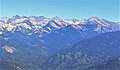 Great Western Divide seen from Moro Rock, Mt. Eisen furthest right
 -
 Eisen alpenglow


See also[edit]
References[edit]
- ^ a b c d "Mount Eisen". Geographic Names Information System. United States Geological Survey, United States Department of the Interior. Retrieved 2021-05-25.
- ^ a b "Mount Eisen, California". Peakbagger.com. Retrieved 2021-05-25.
- ^ a b c d "Eisen, Mount - 12,180' CA". listsofjohn.com. Retrieved 2021-05-25.
- ^ Steve Roper, The Climber's Guide to the High Sierra, 1976, Sierra Club Books, ISBN 9780871561473, page 284.
- ^ R. J. Secor, The High Sierra Peaks, Passes, Trails, 2009, Third Edition, Mountaineers Books, ISBN 9781594857386, page 103.
- ^ Peter Browning, Place Names of the Sierra Nevada: From Abbot to Zumwalt, Wilderness Press, 1986, ISBN 9780899970479, page 63.
- ^ Mildred Jentsch and Arthur J. Reyman, A Climber’s Guide to the High Sierra (1954)
- ^ Peel, M. C.; Finlayson, B. L.; McMahon, T. A. (2007). "Updated world map of the Köppen−Geiger climate classification". Hydrol. Earth Syst. Sci. 11. ISSN 1027-5606.
External links[edit]
- Weather forecast: Mount Eisen
- Gustav Eisen photo and biography