
Mont du Lac des Cygnes
| Mont du Lac des Cygnes | |
|---|---|
.jpg) View of mount and Swan Lake | |
| Highest point | |
| Elevation | 980 m (3,220 ft)[1] |
| Coordinates | 47°39′58″N 70°36′14″W / 47.66611°N 70.60389°W[1] |
| Geography | |
| Location | Charlevoix, Capitale-Nationale, Quebec |
| Country | Canada |
Mont du Lac des Cygnes ("Swan Lake Mountain") is a mountain of the Jacques-Cartier Massif (Laurentian Mountains chain), located within the Grands-Jardins National Park in Quebec, Canada. Its summit culminating at 980 metres (3,220 ft) above sea level and overlooking the valley of the Rivière du Gouffre is one of the main attractions of the park.
Toponymy[edit]
The name of the mountain comes from a lake of the same name located 3 kilometres (1.9 mi) south of it.[1] It was used for the first time on a map of the Parc des Laurentides in 1942. As for the name of the lake, it has an obscure origin, but it would have been known since at least 1850.[2]
Geography[edit]
The summit of Mont du Lac des Cygnes is located in the eastern part of the Grands-Jardins National Park, almost at the limit of Saint-Urbain. The drop between the summit (981 m)[3] and the surface of Lac des Cygnes (320 m), located below, is 660 m. This mountain is delimited between the course of the Rivière du Gouffre Sud-Ouest which passes the valley on the north side, and Le Gros Bras which passes in the valley on the south side.
The summit of the mountain once featured a forest fire observation tower, erected as a metal structure resembling the electricity towers for the transmission of electricity.[4]
Sometimes school groups organize hikes along the path of the Tower to reach the summit. In 2007, students from the music concentration at Jean-de-Brébeuf high school gave a concert at the top of Mont du Lac-des-Cygnes. This hike was organized as part of the International Journal of Music, on October 1. Nearly 200 students from the instrumental music concentration took part in the ascent of the mountain.[5]
Activities[edit]
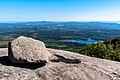
The Mont-du-Lac-des-Cygnes trail in Grands-Jardins National Park is 8.6 kilometres (5.3 mi) long and provides access to the summit. The drop is 480 metres (1,570 ft) (altitude of 480 metres (1,570 ft) at the base and 980 metres (3,220 ft) at the top). It offers a view of Lac des Cygnes, the "Astroblème de Charlevoix" (Charlevoix impact structure) and even the St. Lawrence River.[6]
-
 Scenic view from the summit
 -
 Scenic view from the summit
 -
 Lac des Cygnes


See also[edit]
References[edit]
- ^ a b c Gouvernement du Québec. "Mont du Lac des Cygnes". Commission de Toponymie. Banque de noms de lieux du Québec. Retrieved 30 December 2010.
- ^ Gouvernement du Québec. "Lac des Cygnes". Commission de Toponymie. Banque de noms de lieux du Québec. Retrieved 30 December 2010.
- ^ "Article: "Charlevoix – Sentier Mont-du-Lac-des-Cygnes du Parc national des Grands-Jardins". Tourisme-Charlevoix. Retrieved 29 January 2022.
- ^ "Photo of Swan Lake Tower (no. 26) from Laurentian Forest Association Protective Ltd". BAnQ numérique. Retrieved 30 January 2022.
- ^ Journal L'informateur de la Commission scolaire de la Capitale, article "La musique au sommet du mont du Lac-des-Cygnes" (Music at the top of Mont du Lac-des-Cygnes), p. 3, 5 novembre 2007, with photo of the group of students.
- ^ SÉPAQ. "Randonnée pédestre". SEPAQ-Parc national des Grands-Jardins. Retrieved 30 December 2010.
External links[edit]
![]() Media related to Mont du Lac des Cygnes at Wikimedia Commons
Media related to Mont du Lac des Cygnes at Wikimedia Commons