
McHale, Kansas
McHale, Kansas | |
|---|---|
| Coordinates: 39°16′43″N 99°21′46″W / 39.27861°N 99.36278°W | |
| Country | United States |
| State | Kansas |
| County | Rooks |
| Elevation | 2,100 ft (600 m) |
| Population | |
| • Total | 0 |
| Time zone | UTC-6 (CST) |
| • Summer (DST) | UTC-5 (CDT) |
| Area code | 785 |
| GNIS ID | 482531 [1] |


McHale is a ghost town in Plainville Township, Rooks County, Kansas, United States.[1]
History[edit]
McHale was issued a post office in 1880. The post office was discontinued in 1891. There is nothing left of McHale.[2]
References[edit]
- ^ a b "McHale, Kansas", Geographic Names Information System, United States Geological Survey, United States Department of the Interior
- ^ "Kansas Post Offices, 1828-1961". Kansas Historical Society. Retrieved 2017-12-30.
Municipalities and communities of Rooks County, Kansas, United States | ||
|---|---|---|
| Cities | 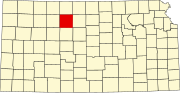 | |
| Unincorporated communities | ||
| Ghost towns | ||
| Townships | ||
| Footnotes | †This community is designated a Census-Designated Place (CDP) by the United States Census Bureau. | |
This article about a location in Rooks County, Kansas is a stub. You can help Wikipedia by expanding it. |