
List of quarries served by the Ffestiniog Railway
The Festiniog Railway served a cluster of quarries around the town of Blaenau Ffestiniog, Wales. Most of these were slate quarries, although granite quarries and zinc mines were also connected by narrow gauge tramways to the railway.[1]
Map
[edit]
The quarries
[edit]| Name | Mineral | Opened | Closed | Years connected | Notes |
|---|---|---|---|---|---|
| Blaen y Cwm | Slate | 1820 | 1911 | 1876–1911 | Connected to the FfR via the Rhiwbach Tramway |
| Bowydd | Slate | 1800 | 1870 | 1854–1870 | Merged with Votty to form Votty & Bowydd quarry |
| Brooke's | Granite | 1919 | ? | ? | Connected by a tramway branching off at the north portal of Moelwyn Tunnel |
| Bwlch-y-Slater | Slate | 1824 | 1960 | 1866–1956 | Connected via the Rhiwbach Tramway |
| Cesail | Slate | 1827 | 1877 | 1836–1877 | Became part of the Oakeley Quarry |
| Conglog | Slate | 1872 | 1920? | 1874–1920 | Remote quarry connected by the Cwmorthin Tramway |
| Cwmorthin | Slate | 1810 | 1937 | 1850–1937 | Connected via the Cwmorthin Tramway; became part of the Oakeley quarry in 1900, the two quarries were connected underground |
| Cwt-y-Bugail | Slate | 1835 | 1972 | 1867–1961 | Last quarry using the (by then partly lifted) Rhiwbach Tramway |
| Diphwys Casson | Slate | 1760 | 1972 | 1860–1955 | Last of the major quarries to be connected to the Ffestiniog Railway |
| Graig Ddu | Slate | 1840 | 1946 | Connected via the Festiniog and Blaenau Railway | |
| Groby Granite | Granite | 1901[2] | Circa 1932 | 1914-c.1932 | Connected by a short, steeply graded branch worked by FfR locomotives. |
| Hafodty (Votty) | Slate | 1801 | 1870 | 1851–1870 | Joined with Bowydd quarry to form Votty & Bowydd |
| Llechwedd | Slate | 1846 | Present | 1848-1980s | Currently worked on a small scale and the site of the Llechwedd Slate Caverns tourist attraction |
| Maenofferen | Slate | 1848 | 1999[3] | 1848–1975 | Became the major owner of quarries connected via inclines at Duffws station, continued to use the stub of the FfR through Blaenau into the mid 1970s. Untopping operations continue in 2007. |
| Nyth-y-Gigfran | Slate | 1840s | 1882 | 1867–1882 | Sometimes known as Glan-y-Pwll quarry. Became part of the Oakeley Quarry |
| Matthews (Rhiwbryfdir) | Slate | 1825 | 1871 | 1842–1871 | Became part of the Oakeley quarry |
| Manod | Slate | c1850 | Present | 1866-1930s | Sometimes known as Bwlch y Slaters and now given the name Cwt y Bugail. Connected to the Festiniog by the Rhiwbach Tramway[4] |
| Moelwyn Slate | Slate | 1826 | c 1900[5] | 1867–c 1900 | Remote quarry connected to the FfR by a series of seven inclines; worked intermittently and never successfully. |
| Moelwyn Zinc | Zinc, Manganese and Silver | c1892[6] | by 1919 | 1892-by 1919 | Zinc mine just west of the north portal of the old Moelwyn Tunnel.[7] |
| Oakeley | Slate | 1878 | 2010[8] | 1878-1950s | Formed by the amalgamation of the Cesail, Matthews and Glan-y-Pwll quarries. Was the largest single quarry in Blaenau Ffestiniog. Was the home of the Gloddfa Ganol tourist attraction in the 1980s and 1990s. Now worked as an open pit by Alfred McAlpine Ltd. |
| Rhiwbach | Slate | 1812 | 1953 | 1860–1953 | Remote quarry situated 4 miles (6.4 km) east of Duffws station and connected via the Rhiwbach Tramway |
| Syenite Setts | Granite | 1874 | 1916 | ? | Quarry later worked as Brooke's[9] |
| Votty & Bowydd | Slate | 1870 | 1964 | 1870–1962 | Formed by the amalgamation of the Hafodty and Bowydd quarries. |
| Wrysgan | Slate | 1830s | 1946 | 1844–1946 | Connected to the railway near Tanygrisiau via a single long incline ending in a tunnel. |
Images
[edit]-
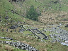
 The ruined mill at Blaen-y-Cwm, in 2005
 -
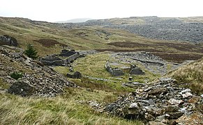
 The remains of Conglog mill
 -
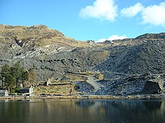 Cwmorthin Quarry seen from across the lake
 -
 Maenofferen adit and mill
 -
 The inclines leading down from Diphwys Casson into Votty & Bowydd
 -
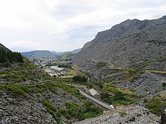 Llechwedd and Oakeley from the north. Llechwedd is on the left, the slate tips on the right are Oakeley
 -
 The incline connecting the Wrysgan quarry to the Festiniog Railway at Tanygrisiau
 -
 The remains of Diphwys Casson mill above the Votty & Bowydd pit
 -
 The Rhiwbach engine house
 -
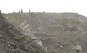
 The cliffs of Nyth-y-Gigfran


References
[edit]- ^ James I. C. Boyd (1975). The Festiniog Railway: Volume 2. The Oakwood Press.
- ^ "The Vale of Ffestiniog: Historical processes and background". Gwynedd Archeological Trust. Archived from the original on 18 October 2012.
- ^ "MAENOFFEREN;MAEN-OFFEREN;MAEN Y FFEREM;MAEN OFFEREN SLATE MINE, BLAENAU FFESTINIOG". Royal Commission on the Ancient and Historic Monuments of Wales.
- ^ Sallery, Dave. "Manod / Welsh Slate's 'Cwt y Bugail Quarry': A brief history of the quarry".
- ^ "MOELWYN SLATE MINE". The Royal Commission on the Historical and Ancient Monuments of Wales.
- ^ Robinson, Iain (25 September 2011). "On the slopes of Moelwyn".
- ^ (Map). 1:2500. Ordnance Survey. 1919.
{{cite map}}: Missing or empty|title=(help) - ^ "Quarry losses hit Snowdonia town". BBC Wales News. 17 March 2010.
- ^ Robinson, Iain (11 March 2012). "Around Llyn Ystradau…an interesting circular walk".
Bibliography
[edit]See also
[edit]Festiniog and associated railways | |
|---|---|
| Current operators | |
| Rolling stock | |
| Stations and halts | |
| Support groups | |
| Other articles | |
| Stations | |
|---|---|
| Other locations | |
| Quarries | |
| People | |
| Rolling stock | |
| Related railways | |
Heritage railways, museums and preservation societies in Wales | |
|---|---|
| Narrow gauge |
|
| Standard gauge | |
| Centres and museums | |
| |