Leabaib
Leabaib
لعبيب | |
|---|---|
Village | |
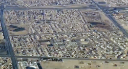
 Aerial view of Leabaib, looking west | |
| Coordinates: 25°23′31″N 51°28′8″E / 25.39194°N 51.46889°E | |
| Country | |
| Municipality | Al Daayen |
| Zone | Zone 70 |
| District no. | 115 |
| Area | |
• Total | 4.4 km2 (1.7 sq mi) |

Leabaib (Arabic: لعبيب, romanized: Li'abaīb) is a village in Qatar, located in the municipality of Al Daayen.[2] It is currently under-development as a mixed-use hub for southern Al Daayen, particularly for residential districts such as Jeryan Nejaima, Al Nuwaimi, and for residences located near Arab League Street.[3]
Geography
[edit]Located in the southwest corner of Al Daayen, Leabaib borders Umm Salal municipality to the west, the Duhail district of Doha to the south and Al Ebb to the north.[4]
Healthcare
[edit]In December 2015, a primary healthcare center was opened in the village. Several public clinics are located within the center, such as a vaccination clinic, dental clinic and radiology clinic.[5]
Visitor attractions
[edit]A 4,376 sq meter family park is located in Leabib. Several local trees such as palm trees and neems are planted in the park.[6]
Development
[edit]The Qatar National Master Plan (QNMP) is described as a "spatial representation of the Qatar National Vision 2030".[7] As part of the QNMP's Urban Centre plan, which aims to implement development strategies in 28 central hubs that will serve their surrounding communities, Leabaib has been designated a District Centre, which is the lowest designation.[8]
Al Daayen municipality is developing Leabaib as a major mixed use center for the municipality's southern sector. Its close proximity to Duhail and the headquarters of Al-Duhail SC will be capitalized on by developing more residential units and government offices in the village. Currently, it is typified by low-density villas, several mosques, three schools, a civic center and a health center. Future plans will see the construction of additional housing so that it may accommodate as many as 30,000 residents.[9]
As the nearest metro station will be 1 kilometre (0.62 mi) west of the district's borders, plans are being drawn up to improve public transportation and the road system. Mid-height buildings will be located in the south of the District Centre. Furthermore, new parks and green spaces are expected to be created.[3]
References
[edit]- ^ "District Area Map". Ministry of Development Planning and Statistics. Retrieved 1 March 2019.
- ^ "2015 Population census" (PDF). Ministry of Development Planning and Statistics. April 2015. Retrieved 25 May 2018.
- ^ a b "Centre Plans and Zoning Regulations" (PDF). Ministry of Municipality and Environment. pp. 191–198. Retrieved 12 November 2019.
- ^ "District map". The Centre for Geographic Information Systems of Qatar. Retrieved 25 May 2018.
- ^ "افتتاح مركز لعبيب الصحي الأحد المقبل" (in Arabic). Al Sharq. 10 December 2015. Retrieved 25 May 2018.
- ^ "حديقة لعبيب". Ministry of Municipality and Environment. Retrieved 25 May 2018.
- ^ "About Qatar National Master Plan". Ministry of Municipality and Environment. Retrieved 14 November 2019.
- ^ "About the Centre Plans". Ministry of Municipality and Environment. Retrieved 14 November 2019.
- ^ "Al Daayen Municipality: Vision and Development Strategy" (PDF). Ministry of Municipality and Environment. December 2017. p. 16. Retrieved 25 May 2018.

