Lac-au-Saumon, Quebec
Lac-au-Saumon | |
|---|---|
 | |
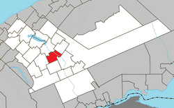
 Location within La Matapédia RCM. | |
| Coordinates: 48°25′N 67°21′W / 48.417°N 67.350°W[1] | |
| Country | |
| Province | |
| Region | Bas-Saint-Laurent |
| RCM | La Matapédia |
| Settled | 1896 |
| Constituted | December 17, 1997 |
| Government | |
| • Mayor | Gérard Grenier |
| • Fed. riding | Avignon—La Mitis— Matane—Matapédia |
| • Prov. riding | Matane-Matapédia |
| Area | |
| • Total | 84.40 km2 (32.59 sq mi) |
| • Land | 81.05 km2 (31.29 sq mi) |
| Population | |
| • Total | 1,488 |
| • Density | 18.4/km2 (48/sq mi) |
| • Pop 2016-2021 | |
| • Dwellings | 646 |
| Demonym | Saumonois |
| Time zone | UTC−5 (EST) |
| • Summer (DST) | UTC−4 (EDT) |
| Postal code(s) | |
| Area code(s) | 418 and 581 |
| Highways | |
| Website | www |
Lac-au-Saumon is a municipality in the Canadian province of Quebec, located in La Matapédia Regional Council Municipality in the Matapédia Valley.
The municipality had a population of 1,488 as of the Canada 2021 Census.
The village is located on the shores of the eponymous Lac au Saumon (French for "Salmon Lake") that is an enlargement of the Matapédia River. It was known as a spawning ground for salmon, but major pollution from mills made this a thing of the past.[1]
History[edit]
The area opened up to colonization in 1863, and the Mission of Saint-Edmond-du-Lac-au-Saumon was founded in 1876. But it was not until 1896 that real settlement began with the arrival of a group of Acadians from the Magdalen Islands. The following year the Lac-au-Saumon post office opened.[1][4]
In 1904, the Municipality of Saint-Edmond was incorporated when it separated from the Parish Municipality of Saint-Benoît-Joseph-Labre (now Amqui). The following year, the Village Municipality of Lac-au-Saumon was established.[1][4]
On December 17, 1997, the Village Municipality of Lac-au-Saumon and the Municipality of Saint-Edmond were amalgamated to form the new Municipality of Lac-au-Saumon.[1]
Geography[edit]
Lac-au-Saumon is located approximately 10 kilometers between the two main towns of La Matapédia, Amqui and Causapscal, on Route 132 which is the main communication axis of Bas-Saint-Laurent and Gaspésie. The latter passes on the north side of the lake although the bulk of the village is located to the south. North of the lake, we find the Notre Dame Mountains which are part of the Chic-Chocs mountains.
Demographics[edit]
| 2021 | 2016 | 2011 | |
|---|---|---|---|
| Population | 1,488 (+2.6% from 2016) | 1,450 (-0.2% from 2011) | 1,453 (-2.8% from 2006) |
| Land area | 81.05 km2 (31.29 sq mi) | 81.08 km2 (31.31 sq mi) | 82.24 km2 (31.75 sq mi) |
| Population density | 18.4/km2 (48/sq mi) | 17.9/km2 (46/sq mi) | 17.7/km2 (46/sq mi) |
| Median age | 53.2 (M: 51.6, F: 54.8) | 51.3 (M: 48.6, F: 53) | 48.5 (M: 46.1, F: 50.4) |
| Private dwellings | 646 (total) 607 (occupied) | 598 (total) | 565 (total) |
| Median household income | $65,000 | $56,107 | $43,079 |
Canada Census data before 2001 (pre-merger):[9]
|
|
Municipal council[edit]
- Mayor: Gérard Grenier
- Councillors: Gérald Ruel, Patrick Bacon, Jocelyne Bérubé, Chantal Gagné, Alain Fradette, Valérie Simard
Mayors of the Municipality of Lac-au-Saumon
(following the merger with Saint-Edmond)
- Gérard Grenier 2017-
- Michel Chevarie 2009-2017
- Jean-Claude Dumoulin 2005-2009
- Aurélien Beaulieu 1998-2005
- Jean-Claude Dumoulin 1997-1998
Mayors of the former Village Municipality of Lac-au-Saumon
|
|
See also[edit]
References[edit]
- ^ a b c d e "Lac-au-Saumon (Municipalité)" (in French). Commission de toponymie du Québec. Retrieved 2012-01-31.
- ^ a b "Lac-au-Saumon". Répertoire des municipalités (in French). Ministère des Affaires municipales, des Régions et de l'Occupation du territoire. Archived from the original on 2011-12-29. Retrieved 2012-01-31.
- ^ a b c "2021 Community Profiles". 2021 Canadian Census. Statistics Canada. February 4, 2022. Retrieved 2023-10-19.
- ^ a b "Saint-Edmond (secteur)" (in French). Commission de toponymie du Québec. Retrieved 2012-01-31.
- ^ "2016 Community Profiles". 2016 Canadian Census. Statistics Canada. August 12, 2021. Retrieved 2022-10-10.
- ^ "2011 Community Profiles". 2011 Canadian Census. Statistics Canada. March 21, 2019. Retrieved 2014-02-01.
- ^ "2006 Community Profiles". 2006 Canadian Census. Statistics Canada. August 20, 2019.
- ^ "2001 Community Profiles". 2001 Canadian Census. Statistics Canada. July 18, 2021.
- ^ "Electronic Area Profiles". Canada 1996 Census. Statistics Canada. Retrieved 2013-05-10.

