
Krag Peak
| Krag Peak | |
|---|---|
 South aspect | |
| Highest point | |
| Elevation | 9,079 ft (2,767 m)[1] |
| Prominence | 1,240 ft (378 m)[2] |
| Parent peak | Red Mountain (9,537 ft)[3] |
| Isolation | 2.12 mi (3.41 km)[3] |
| Coordinates | 45°03′55″N 117°17′21″W / 45.0652516°N 117.2892716°W[1] |
| Geography | |
 Krag Peak Location in Oregon  Krag Peak Krag Peak (the United States) | |
| Location | Eagle Cap Wilderness |
| Country | United States of America |
| State | Oregon |
| County | Baker |
| Parent range | Wallowa Mountains |
| Topo map | USGS Krag Peak |
| Climbing | |
| Easiest route | scrambling[4] |
Krag Peak is a mountain summit located in Baker County, Oregon, US.[1]
Description[edit]
Krag Peak is located in the southern Wallowa Mountains. The double summit peak is situated within the Eagle Cap Wilderness on land managed by Wallowa–Whitman National Forest.[2] The 9,079-foot elevation (2,767 m) summit and slightly lower northwest peak (9,048 ft) ranks as the 42nd-highest mountain in Oregon, and third-highest in Baker County following Red Mountain and Rock Creek Butte.[3][5] It ranks tied for 27th-highest in Oregon when 500-foot minimum topographic prominence is included as criteria.[2][6] Precipitation runoff from the mountain drains west into East Fork Eagle Creek, and east to the Imnaha River via Cliff Creek. Topographic relief is significant as the summit rises nearly 4,500 feet (1,400 meters) above East Fork Eagle Creek in approximately one mile. This landform's toponym has been officially adopted by the United States Board on Geographic Names.[1]
Climate[edit]
Based on the Köppen climate classification, Krag Peak is located in a subarctic climate zone characterized by long, usually very cold winters, and mild summers.[7] Winter temperatures can drop below −10 °F with wind chill factors below −20 °F. Most precipitation in the area is caused by orographic lift. Thunderstorms are common in the summer.
See also[edit]
Gallery[edit]
-
 South aspect of Krag Peak with Eagle Creek
 -
 North aspects of Red Mountain (left) and Krag Peak (right).
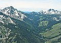
Cliff Creek valley centered -
 Krag Peak in the distance
.jpg)
.jpg)
.jpg)
References[edit]
- ^ a b c d "Krag Peak". Geographic Names Information System. United States Geological Survey, United States Department of the Interior. Retrieved October 11, 2022.
- ^ a b c "Krag Peak, Oregon". Peakbagger.com. Retrieved October 11, 2022.
- ^ a b c "Krag Peak - 9,100' OR". listsofjohn.com. Retrieved October 11, 2022.
- ^ Barbara I. Bond (2005), 75 Scrambles in Oregon, Mountaineers Books, ISBN 9781594852909
- ^ United States Geological Survey topographical map - Krag Peak
- ^ Oregon's tallest 100 peaks with 500' of prominence, yellowleaf.org
- ^ Peel, M. C.; Finlayson, B. L.; McMahon, T. A. (2007). "Updated world map of the Köppen−Geiger climate classification". Hydrol. Earth Syst. Sci. 11: 1633–1644. ISSN 1027-5606.