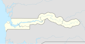
Kaolang Forest Park
| Kaolang Forest Park | |
|---|---|
IUCN category IV (habitat/species management area) | |
| Location | Central River Division |
| Nearest city | Brikama Ba |
| Coordinates | 13°34′32″N 15°01′30″W / 13.57556°N 15.02500°W |
| Area | 2379 hectares |
| Established | January 1, 1954 |
Kaolang Forest Park is a forest park in the Gambia. Established on January 1, 1954, it covers 2379 hectares.[1]
It lies on both sides of the South Bank Road, Gambia's main trunk road, along the stretch between Soma and Brikama Ba. The Kaolang Forest Park is about twelve kilometers before Brikama Ba and eight kilometers after Kundang.[2]
References[edit]
- ^ "World Database of Protected Areas:Gambia". UNEP, World Commission on Protected Areas. Archived from the original on September 6, 2008. Retrieved August 22, 2008.
- ^ "Kaolang Forest Park – Biologie". www.biologie-seite.de (in German). Retrieved 2020-11-26.

