Iona, Nova Scotia
This article on a place of local interest may need more verifiable and notable information. (January 2023) |
Iona | |
|---|---|
Unincorporated community | |
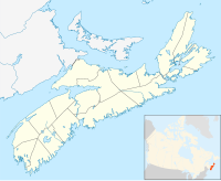
Location of Iona in Nova Scotia | |
| Coordinates: 45°57′45″N 60°48′17″W / 45.96250°N 60.80472°W | |
| Country | |
| Province | |
| County municipality | Victoria County |
| Time zone | UTC-4 (AST) |
| • Summer (DST) | UTC-3 (ADT) |
| Forward sortation area | |
| Area code(s) | 902 and 782 |
| NTS Map | 011/F15 |
| GNBC Code | CARNE |
Iona (Scottish Gaelic: Sanndraigh) is an unincorporated place in the Municipality of the County of Victoria, Cape Breton Island, Nova Scotia, Canada. It is named after Iona in Scotland. It is at the western end of the Barra Strait Bridge, opposite Grand Narrows.
Iona was settled by Gaelic speaking immigrants from the Isle of Barra in 1802. It is the site of Highland Village Museum (An Clachan Gàidhealach) and the Rankin School of the Narrows.


