Indre Arna
Appearance
Indre Arna | |
|---|---|
Neighborhood in Bergen | |
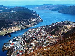
 View of the neighborhood with Ådnanipa in Indre Arna in the foreground | |
| Coordinates: 60°25′04″N 5°28′15″E / 60.4177°N 5.4709°E | |
| Country | Norway |
| Region | Western Norway |
| County | Vestland |
| Municipality | Bergen |
| Borough | Arna |
| Area | |
• Total | 3.96 km2 (1.53 sq mi) |
| Elevation | 38 m (125 ft) |
| Population (2012) | |
• Total | 6,536 |
| • Density | 1,651/km2 (4,280/sq mi) |
| Time zone | UTC+01:00 (CET) |
| • Summer (DST) | UTC+02:00 (CEST) |
Indre Arna is a suburban village in the borough of Arna in the municipality of Bergen in Vestland county, Norway. While Indre Arna is relatively far from most of the city centre by road, there is an 8-minute train journey through the mountain Ulriken from Indre Arna to the city centre. Arna Church is located in the village.
The 3.96-square-kilometre (980-acre) village has a population (2012) of 6,536 and a population density of 1,651 inhabitants per square kilometre (4,280/sq mi).[2] Since 2013, Statistics Norway no longer tracked separate population statistics for Indre Arna, instead the village was incorporated into a larger urban area called Arna.[3]
References
[edit]- ^ "Indre Arna, Bergen (Vestland)". yr.no. Retrieved 17 June 2020.
- ^ Statistisk sentralbyrå (1 January 2019). "Urban settlements. Population and area, by municipality".
- ^ Statistisk sentralbyrå (1 January 2013). "Nye og utgåtte tettsteder" (in Norwegian).


