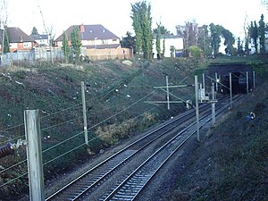
Handsworth Wood railway station
Appearance
Handsworth Wood | |
|---|---|
 The site in 2010 | |
| General information | |
| Location | Handsworth Wood, Birmingham England |
| Coordinates | 52°30′43″N 1°55′17″W / 52.5120°N 1.9215°W |
| Grid reference | SP053904 |
| Platforms | 2 |
| Other information | |
| Status | Disused |
| History | |
| Pre-grouping | London and North Western Railway |
| Post-grouping | London, Midland and Scottish Railway |
| Key dates | |
| 1896 | Opened[1] |
| 1941 | Closed[1] |

Handsworth Wood railway station was a railway station in Handsworth Wood, Birmingham, England. It was found on the London and North Western Railway link between the Chase Line and the West Coast Main Line. The station operated between 1896 and 1941, and like neighbouring station Soho Road, closed during the Second World War,[1] as a result of decreasing use by passengers who possibly found the new 16 bus route more convenient.
The station site lies in a cutting through Handsworth Park, adjacent to St. Mary's Church.
| Preceding station | Disused railways | Following station | ||
|---|---|---|---|---|
| Soho Road | London and North Western Railway Soho Junction to Perry Barr Junction |
Hamstead or Perry Barr Chase Line |
References
[edit]Wikimedia Commons has media related to Handsworth Wood railway station.
- ^ a b c "Handsworth Wood Station". Rail Around Birmingham. 2004. Retrieved 8 November 2008.
Categories:
- Disused railway stations in Birmingham, West Midlands
- Former London and North Western Railway stations
- Railway stations in Great Britain opened in 1896
- Railway stations in Great Britain closed in 1941
- Handsworth, West Midlands
- West Midlands (county) building and structure stubs
- West Midlands (region) railway station stubs
