
Gunnerside
| Gunnerside | |
|---|---|
 Gunnerside from the south side of the valley | |
.svg) Gunnerside Location within North Yorkshire | |
| OS grid reference | SD951982 |
| • London | 210 mi (340 km) SE |
| Civil parish | |
| Unitary authority | |
| Ceremonial county | |
| Region | |
| Country | England |
| Sovereign state | United Kingdom |
| Post town | DARLINGTON |
| Postcode district | DL11 |
| Dialling code | 01748 |
| Police | North Yorkshire |
| Fire | North Yorkshire |
| Ambulance | Yorkshire |
| UK Parliament | |
Gunnerside is a village in North Yorkshire, England. It is situated in Swaledale, on the B6270 road, 3 miles (5 km) east of Muker and 6 miles (10 km) west of Grinton.[1][2] The village lies between the River Swale and its tributary, Gunnerside Beck, and is within the Yorkshire Dales National Park.
History[edit]
The name of the village derives from an Old Norse personal name Gunnar and sætr meaning hill or pasture.[3][4]
Gunnerside Ghyll (or Gunnerside Gill), a smaller valley running northwards, at right angles to the Swale valley (Swaledale), was the site of a major lead mining industry in Swaledale from the 17th century[5] to the late 19th century.[6] The beck that runs through the narrow valley, also called Gunnerside Gill, or Gunnerside Beck, rises between Rogan's Seat and Water Crag,[7] and runs for 5 miles (8 km) emptying into the River Swale at the site of Gunnerside New Bridge.[8] The bridge carries the B6270 over the River Swale south of the village; it was rebuilt several times during the 19th century due to flooding.[9] The current structure dates from around 1892 and is now grade II listed.[10]
The area attracts many ramblers who use the foot tracks for exploring the area. Some decide to visit The Old Working Smithy & Museum, established in 1795, for a modest admission fee.[11][12] The site contains historic items.
Gunnerside is served by a Methodist Chapel, a part-time post office, a weekly market, a restaurant and some shops selling food items. [13] The chapel was founded in 1789, but rebuilt in 1866.[14] The structure is now grade II listed.[15] A private building to the north of the crossroads in the village was the site of a Medieval corn mill, and in the early 20th century, a bus garage.[16] At the foot of Gunnerside Ghyll is the Kings Head public house.
The village primary school is one of two sites of the Reeth and Gunnerside Schools.[17] At the last Ofsted inspection in 2023, the primary school was rated as Good.[18]
Local employment centres on tourism,[19] clockmaking, hill farming, gamekeeping and construction, the latter concerned chiefly with the maintenance of traditional stone-built field walls, houses and field barns. The latter, also known as laithes, are typically referred to as "cow'uses" or cow houses in Swaledale.[20]
Notable people[edit]
- John Close, poet, was born in the village in 1816[21]
-
 Stone barns in the meadows near Gunnerside New Bridge
 -
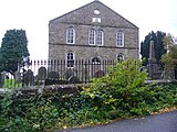 Methodist Chapel
 -
 Approaching Gunnerside


See also[edit]
- Operation Gunnerside, which may have got its name because the participants trained on a moor near to Gunnerside owned by Charles Hambro.[22]
References[edit]
- ^ "Descriptive Gazetteer Entry for Gunnerside". visionofbritain.org.uk. Retrieved 17 June 2021.
- ^ "Genuki: In 1822, the following places were in the Parish of Grinton:, Yorkshire (North Riding)". www.genuki.org.uk. Retrieved 17 June 2021.
- ^ Fleming, Andrew (1999). "3;Small-scale communities and the landscape of Swaledale". In Ucko, Peter; Layton, Robert (eds.). The archaeology and anthropology of landscape : shaping your landscape (1 ed.). London: Routledge. p. 69. ISBN 9780415117678.
- ^ Ekwall, Eilert (1960). The concise Oxford dictionary of English place-names (4 ed.). Oxford: Clarendon Press. p. 399. ISBN 0-19-869103-3.
- ^ "Gunnerside". The Express. 15 June 2021. Retrieved 25 October 2023.
- ^ "Gunnerside Gill lead mines". www.outofoblivion.org.uk. Retrieved 17 June 2021.
- ^ Speight 1897, p. 265.
- ^ "Gunnerside Gill from Source to River Swale". environment.data.gov.uk. Retrieved 17 June 2021.
- ^ Speight 1897, p. 253.
- ^ Historic England. "Gunnerside New Bridge (Grade II) (1179749)". National Heritage List for England. Retrieved 17 June 2021.
- ^ "The Old Working Smithy & Museum - Gunnerside". The Old Working Smithy. 1 June 2020. Retrieved 25 October 2023.
- ^ "Gunnerside". Dales Discoveries. 15 June 2021. Retrieved 25 October 2023.
- ^ "Local Food Shops and Producers near Gunnerside, North Yorkshire". Big Barn. 11 May 2022. Retrieved 25 October 2023.
- ^ "Parishes: Grinton | British History Online". www.british-history.ac.uk. Retrieved 17 June 2021.
- ^ Historic England. "Methodist Chapel (Grade II) (1130790)". National Heritage List for England. Retrieved 17 June 2021.
- ^ "Gunnerside corn mill". www.outofoblivion.org.uk. Retrieved 17 June 2021.
- ^ Philby, Charlotte (19 September 2009). "The lost villages of Britain: Can our rural communities survive in the 21st century?". The Independent. Retrieved 9 October 2017.
- ^ "Gunnerside Methodist Primary School URN: 121542". reports.ofsted.gov.uk. Retrieved 25 October 2023.
- ^ "Why You Should Visit Swaledale". Living North. 11 June 2021. Retrieved 26 October 2023.
- ^ "Field barns and cow'uses". Dales Discoveries. 3 May 2019. Retrieved 25 October 2023.
Barns were used as a combination of cattle housing and fodder storage
- ^ Brown, Douglas. "Close, John [called Poet Close]". Oxford Dictionary of National Biography (online ed.). Oxford University Press. doi:10.1093/ref:odnb/5704. (Subscription or UK public library membership required.)
- ^ "Knut Haugland". The Telegraph. 28 December 2009. Retrieved 9 October 2017.
Sources[edit]
- Speight, Harry (1897). Romantic Richmondshire: Being a complete account of the history, antiquities and scenery of the picturesque valleys of the Swale and Yore. London: E Stock. OCLC 252008733.