
File:USGS Community Internet Intensity Map 30 May 2015 Bonin Islands Earthquake M 7.8.pdf
Size of this JPG preview of this PDF file: 463 × 599 pixels. Other resolutions: 185 × 240 pixels | 371 × 480 pixels | 593 × 768 pixels | 1,275 × 1,650 pixels.
Original file (1,275 × 1,650 pixels, file size: 122 KB, MIME type: application/pdf)
| This is a file from the Wikimedia Commons. Information from its description page there is shown below. Commons is a freely licensed media file repository. You can help. |
Summary
| Description |
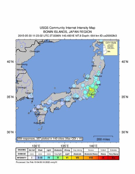
English: USGS Community Internet Intensity Map
BONIN ISLANDS, JAPAN REGION 2015-05-30 11:23:02 UTC 27.8386N 140.4931E M7.8 Depth: 664 km ID:us20002ki3 |
| Date | |
| Source | https://earthquake.usgs.gov/product/dyfi/us20002ki3/us/1645243233490/us20002ki3_ciim.pdf |
| Author | United States Geological Survey |
Most up-to-date maps:
https://earthquake.usgs.gov/earthquakes/eventpage/us20002ki3/dyfi/intensity
Licensing
This image is in the public domain in the United States because it only contains materials that originally came from the United States Geological Survey, an agency of the United States Department of the Interior. For more information, see the official USGS copyright policy.
|
File history
Click on a date/time to view the file as it appeared at that time.
| Date/Time | Thumbnail | Dimensions | User | Comment | |
|---|---|---|---|---|---|
| current | 05:06, 2 January 2024 |  | 1,275 × 1,650 (122 KB) | Sapiann | Uploaded a work by United States Geological Survey from United States Geological Survey with UploadWizard |
File usage
The following pages on the English Wikipedia use this file (pages on other projects are not listed):