
File:The Cenotaph and Memorial Gardens, Rochdale, Lancashire - geograph.org.uk - 344002 (cropped).jpg

No higher resolution available.
The_Cenotaph_and_Memorial_Gardens,_Rochdale,_Lancashire_-_geograph.org.uk_-_344002_(cropped).jpg (304 × 203 pixels, file size: 53 KB, MIME type: image/jpeg)
| This is a file from the Wikimedia Commons. Information from its description page there is shown below. Commons is a freely licensed media file repository. You can help. |
Summary
| Description |
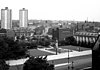
English: The Cenotaph and Memorial Gardens, Rochdale, Lancashire In this 1968 photograph, at first sight it seems as though there is little change since 1966, but the new ring road has been constructed behind the Salvation Army citadel and is open for traffic. |
| Date | |
| Source |
This file was derived from: The Cenotaph and Memorial Gardens, Rochdale, Lancashire - geograph.org.uk - 344002.jpg |
| Author | Dr Neil Clifton |
| Other versions | |
| Attribution (required by the license) | Dr Neil Clifton / The Cenotaph and Memorial Gardens, Rochdale, Lancashire / |
| Camera location | | View this and other nearby images on: OpenStreetMap |
|---|
| Object location | | View this and other nearby images on: OpenStreetMap |
|---|
Licensing
This file is licensed under the Creative Commons Attribution-Share Alike 2.0 Generic license.
Attribution: Dr Neil Clifton
- You are free:
- to share – to copy, distribute and transmit the work
- to remix – to adapt the work
- Under the following conditions:
- attribution – You must give appropriate credit, provide a link to the license, and indicate if changes were made. You may do so in any reasonable manner, but not in any way that suggests the licensor endorses you or your use.
- share alike – If you remix, transform, or build upon the material, you must distribute your contributions under the same or compatible license as the original.
- Remove redundant categories and try to put this image in the most specific category/categories
- Remove this template
- The location categories are based on information from this geonames tool and this OpenStreetMap tool combined with a database. You can also have a look at this tool from mysociety.
- The topic category from Geograph was Town scene (find similar images scene at Geograph)
File history
Click on a date/time to view the file as it appeared at that time.
| Date/Time | Thumbnail | Dimensions | User | Comment | |
|---|---|---|---|---|---|
| current | 03:03, 12 January 2018 |  | 304 × 203 (53 KB) | Carcharoth | File:The Cenotaph and Memorial Gardens, Rochdale, Lancashire - geograph.org.uk - 344002.jpg cropped 53 % horizontally and 55 % vertically using CropTool with precise mode. |
File usage
The following pages on the English Wikipedia use this file (pages on other projects are not listed):