
File:Ontario 61 map.svg

Size of this PNG preview of this SVG file: 600 × 600 pixels. Other resolutions: 240 × 240 pixels | 480 × 480 pixels | 768 × 768 pixels | 1,024 × 1,024 pixels | 2,048 × 2,048 pixels.
Original file (SVG file, nominally 600 × 600 pixels, file size: 1.7 MB)
![]() ✗
The source code of this SVG is invalid due to 471 errors.
✗
The source code of this SVG is invalid due to 471 errors.
| Description |
A map of Ontario Highway 61 (in red) in Thunder Bay District. | ||
|---|---|---|---|
| Source |
Own work . Roads and Pigeon River / Ontario-Minnesota border traced using Google Earth, Lake Superior outline provided by the National Oceanic and Atmospheric Administration (NOAA) through the Great Lakes Information Network (GLIN)[1] Shields available on Commons. | ||
| Date | |||
| Author | |||
| Permission (Reusing this file) |
|
| The uploader or another editor requests that a local copy of this file be kept. This image or media file may be available on the Wikimedia Commons as File:Ontario 61 map.svg. While the license of this file may be compliant with the Wikimedia Commons, an editor has requested that the local copy be kept too. This file does not meet CSD F8 and should not be tagged as a Commons duplicate. If you desire to nominate it for deletion, notify the tagging editor. |
File history
Click on a date/time to view the file as it appeared at that time.
| Date/Time | Thumbnail | Dimensions | User | Comment | |
|---|---|---|---|---|---|
| current | 05:52, 12 November 2013 |  | 600 × 600 (1.7 MB) | Floydian (talk | contribs) | ON 130 is still active |
| 23:48, 11 November 2013 | 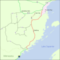 | 600 × 600 (1.7 MB) | Floydian (talk | contribs) | {{Information |Description = A map of Ontario Highway 61 (in red) in Thunder Bay District. |Source = {{own}} |Date = ~~~ |Author = '''<font color="#5A5AC5">Floydian</font>''' <sup>[[User_talk:... |
You cannot overwrite this file.
File usage
The following file is a duplicate of this file (more details):
- File:Ontario 61 map.svg from Commons
The following pages on the English Wikipedia use this file (pages on other projects are not listed):