
File:Map or Plan of Section 27. (Bounded by Broadway, Van Cortlandt Park South, Gun Hill Road, Jerome Avenue and Mount Vernon Avenue.) NYPL1526461.tiff

Size of this JPG preview of this TIF file: 800 × 513 pixels. Other resolutions: 320 × 205 pixels | 640 × 411 pixels | 1,024 × 657 pixels | 1,280 × 821 pixels | 2,560 × 1,642 pixels | 7,230 × 4,638 pixels.
Original file (7,230 × 4,638 pixels, file size: 95.97 MB, MIME type: image/tiff)
| This is a file from the Wikimedia Commons. Information from its description page there is shown below. Commons is a freely licensed media file repository. You can help. |
Summary
| Description | Map or Plan of Section 27. [Bounded by Broadway, Van Cortlandt Park South, Gun Hill Road, Jerome Avenue and Mount Vernon Avenue.]; Atlases of New York city. / Maps or plans and profiles, with field notes and explanatory remarks, showing the location, width, grades, and class of streets, roads, avenues, public squares and places, located and laid out by the Commissioner of Street Improvements of the 23rd and 24th wards of the city of New York : under authority of Chapter 545 of the laws of 1890. | |||||||||||||||||||||||
| Catalogue call number | Map Div. (Bronx, West, N.Y. set. 1:1,800) (Maps or plans and profiles) | |||||||||||||||||||||||
| Item/Page/Plate | 87 | |||||||||||||||||||||||
| Alternate title | Section 27 of Final Maps and Profiles, of the 23rd and 24th Wards. | |||||||||||||||||||||||
| Date | between 1892 and 1895 | |||||||||||||||||||||||
| Source |
http://digitalgallery.nypl.org/nypldigital/dgkeysearchdetail.cfm?imageID=1526461
|
|||||||||||||||||||||||
| Author | New York (N.Y.). Topographical Bureau - Author | |||||||||||||||||||||||
| Permission (Reusing this file) |
From The Lionel Pincus and Princess Firyal Map Division. http://maps.nypl.org
|
|||||||||||||||||||||||
| Source description | 28 maps; 74 x 130 cm. + title sheet and index map. | |||||||||||||||||||||||
| Location | Stephen A. Schwarzman Building / The Lionel Pincus and Princess Firyal Map Division | |||||||||||||||||||||||
| Digital item published | 7-26-2006; updated 3-7-2012 | |||||||||||||||||||||||
| Digital ID | 1526461 | |||||||||||||||||||||||

The making of this file was supported by Wikimedia UK.
To see other files made with the support of Wikimedia UK, please see the category Supported by Wikimedia UK.
|
File history
Click on a date/time to view the file as it appeared at that time.
| Date/Time | Thumbnail | Dimensions | User | Comment | |
|---|---|---|---|---|---|
| current | 03:02, 4 May 2014 | 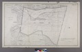 | 7,230 × 4,638 (95.97 MB) | Fæ | GWToolset:: Creating mediafile for Fæ. Tranche 3 17512-20314 @ 11:54, 3 March 2014 |
File usage
The following pages on the English Wikipedia use this file (pages on other projects are not listed):